Issue Date: Monday, September 24th, 2018
Issue Time: 1:20 PM MDT
Valid Dates: 9/25 – 10/9
Fall has officially begun and temperatures this week will finally start to feel more seasonable. Overnight, a cold front dropped through the state associated with the upper-level trough that created some early morning cloud cover and cooler temperatures. There were also some showers over the higher terrains due to upper-level dynamics associated with the trough. This afternoon, expecting showers and thunderstorms to return to the forecast as the rest of the trough pushes across the state. Behind the trough, northwest flow has pulled in dry air over the Northwest Slope, which paired with high surface winds, has created critical fire weather. The entrainment of dry air will limit widespread precipitation to one day, though there may be some isolated showers tomorrow afternoon over the Southeast Mountains (Event #1). The upper-level jet over northern Colorado will continue to produce gusty winds overnight on Monday into Tuesday. For the rest of this week, northwest flow will be present over the state as an elongated trough remains up over the eastern US. This will usher in a series of cold fronts; hence the cooler high temperatures for the first part of this FTO. The first of these fronts will pass through early tomorrow morning and may have some light showers associated with it. Temperatures over the state tomorrow are expected to be in the 60Fs to mid-70Fs, which is a welcomed treat after the long stretch of 90F+ high temperatures.
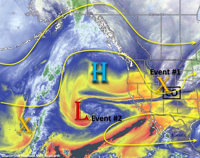
Looking below to the water vapor imagery, very dry air remains present over the desert southwest and Great Basin. This dry air is expected to work its way into the state with the northwest flow aloft the next couple of days. Without much moisture, only isolated, high-based showers and cloud cover are likely over the higher terrains until this weekend. Starting Thursday, a vorticity max starts to move over the west coast. As the cutoff low gets picked up into the main flow later this week and helps turn winds aloft to southwesterly on Saturday. This will allow a little more moisture to return to the state and bring showers and thunderstorms back into the forecast for the western mountains this weekend (Event #2). By Sunday, drier air replaces the weak moisture plume, which will in turn reduce showers and thunderstorms over the higher terrains. So storms on Sunday will be more isolated than scattered in nature. Finally, the upper-level jet on the front side of the trough moves into western Colorado on Sunday, and moves over northern Colorado on Monday. There will likely be enhanced fire weather these two days as increased surface winds pair with low relative humidity values and dry fuels. Please tune back into Thursday’s FTO for changing details.
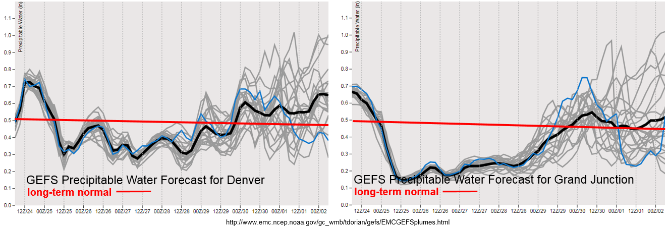
After showers on Monday afternoon, Precipitable Water (PW) values look to drop off both east and west of the Continental Divide as NW flow aloft ushers in dry air. With such low PW values over western Colorado, there will be enhanced, and moments of critical fire weather, throughout the week. Please use caution with any activity that can produce a spark. Looks like a little better moisture east after Monday, though outside isolated showers and weak thunderstorms are expected over the south high terrains on Tuesday. After that, only expecting afternoon cloud cover during the afternoon and evenings. PW looks to increase this weekend as the cutoff low moves into the area. Still quite a spread in the model members, but there should be enough low-level moisture for showers and thunderstorms to return to the forecast on Saturday and Sunday. Please tune back into the FTO on Thursday as model members come into better agreement about moisture return. With PW values remaining below 1 inch during this FTO, there is No Apparent Threat at this time.
Below we describe the two identified precipitation events of this FTO in more detail.
Event #1: Tuesday (9/25)
No Apparent Threat as residual moisture initiates some isolated showers and weak thunderstorms over the Southeast Mountains.
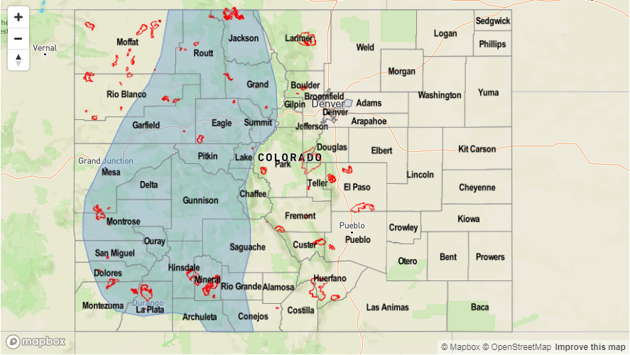
A secondary cold front will drop through the plains overnight into tomorrow morning. There is a chance for some light showers along the front as it surges south during the morning hours. Expecting some gusty winds to accompany the front as well. High temperatures for Tuesday will be in the 60Fs to mid-70Fs, so convection will likely remain capped north of the Palmer Ridge. Weak upslope flow is forecast for the Southeast Mountains during the afternoon, which may initiate some isolated showers and weak thunderstorms. A weak shortwave in the area will help these storms survive as they move east into the Southeast Plains. Totals are expected to remain below 0.5 inches, so a precipitation map has not be drawn.
Event #2: Saturday (9/29) – Sunday (9/30)
No Apparent Threat as a cutoff low gets picked up by the westerly flow and returns some moisture and upper-level energy to the state.
A cutoff low begins to move onshore Thursday this week. By Saturday, southwest flow is expected to return to the state, which will bring an increase in moisture. Shortwave activity is also expected to be on the rise during this period, which if timed correctly, will help with better rainfall coverage. The increase in moisture and upper-level dynamics should bring showers and thunderstorms back into the forecasts for the western, higher terrains this weekend. Still quite a bit of spread between the members as to how much low-level moisture will return, but PW values are expected to stay under 1 inch. That means there is No Apparent Threat at this time.


