Issue Date: Friday, September 21st, 2018
Issue Time: 08:55AM MDT
— Flooding is NOT expected today
Taking a look at the visible satellite imagery below, there are some moderate showers and cloud cover over the Southeast Mountains and Raton Ridge this morning. These upslope showers fired earlier this morning after the passage of a secondary cold front. Isolated showers are expected through noontime before drier air works its way in from the west. There is also some low cloud cover over the northern Urban Corridor, but this will quickly burn off with the morning heating. Temperatures overnight dropped very low with efficient radial cooling due to mostly clear skies. Highs this morning over the plains were in the 40Fs with low 30Fs over the Northwest Slope. This likely means that some of the mountain valleys dropped into the 20Fs. Expecting similar lows tonight even though high temperatures today will be slightly above normal. Perfect timing for these large diurnal temperature swings since fall officially begins tomorrow.
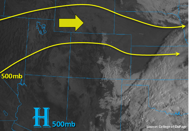
Today the ridge in the image below will begin to slide east as the 500mb high works its way to the NM/AZ border. This means higher heights will build over the state, which will bring calmer weather. The 500mb high will set the stage for WSW winds aloft, and with the 500mb high moving east, moisture should remain to our south and east as well. The WSW winds will entrain a dry air mass from Utah and Arizona, both of which are cloud free at this moment. So outside of morning showers over the Raton Ridge and Southeast Mountains, not expecting measureable rainfall this afternoon. There will be enough moisture for some high clouds and an isolated high-based showers or two near the Continental Divide this afternoon. These storms will likely produce sprinkles and brief winds though minor accumulations are possible. Flooding is not expected today.
Today’s Flood Threat Map
For more information on today’s flood threat, see the map below. For Zone-Specific forecasts, scroll below the map.
Zone-Specific Forecasts:
Urban Corridor, Palmer Ridge, Northeast Plains, Southeast Plains, Raton Ridge, Front Range, Southeast Mountains:
Some moderate upslope showers are present over the Southeast Mountains and Raton Ridge. These showers fired early this morning in the wake of a secondary cold front. Expecting these storms to last until noontime with max totals up to 0.25 inches. WSW flow will begin to entrain a drier air mass this afternoon, and with rising heights, not expecting much rainfall this afternoon. The dry air should also begin to break up the clouds over the Southeast Mountains and adjacent plains throughout the day. More afternoon cloud cover will be likely over the higher terrains near the Continental Divide, and an isolated high-based shower or two is possible. Though these storms may produce brief rain, not expecting totals over 0.1 inches.
Primetime: 9AM to 8PM
Northern Mountains, Northwest Slope, Central Mountains, Grand Valley, San Juan Mountains, Southwest Slope, San Luis Valley:
Drier air continues to be entrained from the WNW as the ridge builds over the area today. Without the jet influencing surface winds today, we should get a brief break in fire weather. Surface wind speeds today should remain around 5mph, though there is a fire weather watch for the Northwest Slope on Saturday and Sunday. This afternoon increased cloud cover is likely over the southern high terrains near the Continental Divide, so there may be an isolated shower or two. Totals up to 0.1 inches are possible. Morning temperatures were quite low, but expecting high temperatures to reach the mid-70Fs at the lower elevations and 60Fs over the mountains. Grand Valley high temperatures are forecast to reach the mid-80Fs.