Issue Date: Thursday, September 20th, 2018
Issue Time: 1:30 PM MDT
Valid Dates: 9/21 – 10/5

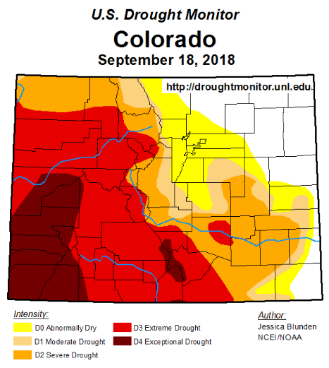
The mid-September heat wave has finally ended with cooler temperatures filling in after the passage of a cold front. Below is the US Drought Monitor that was updated on Tuesday. Not many changes to eastern Colorado, but the Grand Valley region went from extreme drought to exceptional drought. The area experiencing extreme drought in Colorado is now up to 12.6%, which is up about 3% higher than the September 11th map. While some beneficial rain fell over this area yesterday, chances are it was not enough to lift the extreme drought conditions. The climatology of this region shows October receiving more rainfall than September; however, the CPC precipitation outlook has predicted a 33 to 40% chance for above average precipitation at the beginning of October. Hopefully, this pans out as the area desperately needs the moisture.
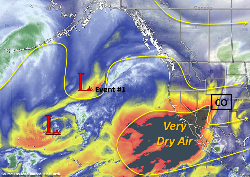
Taking a look at the water vapor imagery below, you can see some very dry air in the desert southwest and west of California. This dry air is currently working its way in behind the trough over Colorado with WSW flow aloft. The strong orange/blue gradient shows just how different these air masses are and the dry air is quickly mixing out any remaining moisture and producing blue skies. Friday into this weekend, flow aloft will turn more westerly with a slight southerly component at the end of the weekend. This will continue to entrain the dry air seen in the water vapor imagery below and without much moisture to work with, not expecting much rainfall (if any) this weekend. Some isolated weak, high-based storms may form over the mountains likely near or along the southern portion of the Continental Divide. By Sunday, the next trough begins to move inland form the west coast (Event #1). Only a minimal amount of moisture is expected to move into the state from west to east with the trough. Without a strong moisture sure anticipated, there is No Apparent flood threat.
The trough begins to propagate through the state on Sunday night starting over the northwest corner, so some high-based, light showers will be possible overnight. The NAM has the trough arriving a little later, so showers may start Monday morning. As the main axis of the trough moves through Monday, expecting storm chances to increase. A weak cold front associated with the trough will drop through the eastern plains on Monday. Not expecting much moisture return behind the front, but this will likely increase the chances for rainfall over the eastern mountains and adjacent plains on Monday. On Tuesday, northwest flow aloft will pick back up and general subsidence behind the trough should limit afternoon rainfall. With northwest flow over the state, another trough will be ushered into the area mid-next week. This system does not look to have much moisture with it, but is expected drop a strong cold front through the area overnight on Wednesday. At this time, high temperatures look to drop into the 60Fs over eastern Colorado for Thursday. After Thursday, northwest flow begins again, which should bring another break in rainfall activity through the weekend as dry air works its way into the state.
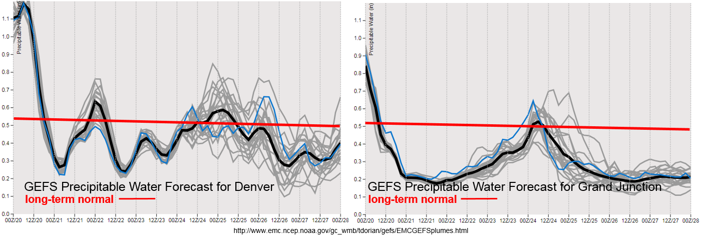
Just how dry is that air mass in the water vapor imagery above? Precipitable Water (PW) values are expected to drop about 0.7 inches across Colorado. This is an incredible drop off in moisture over a 24-hour period. Both PW plumes shows a little bit of moisture return after the frontal passage on Sunday, through PW values only return to around 0.5 inches. This may help to increase storm activity a bit with the help of upper-level dynamics, but these more seasonal PW values will likely increase afternoon cloud cover and produce gusty thunderstorms. This forecast is still a bit far out, so please tune back into the FTO on Monday as details in the forecast may change.
As far as fire danger, expecting surface winds to pick up over northern Colorado starting Sunday night with the trough passage and associated upper-level jet. With warm temperatures still expected on Monday and low relative humidity values, critical fire conditions may be met over this area. Please tune back into the FTB on Monday for more details. For a longer outlook, should the next trough drop into northern Colorado on Wednesday and Thursday there will likely be enhanced fire weather. The GFS is producing a very strong system, so if the intense upper-level jet mixes down to the surface it would produce some very gusty surface winds over northern Colorado. This portion of the forecast is still quite far out, but worth mentioning due to the strength of system in the models.
Below we describe the identified precipitation event of this FTO in more detail.
Event #1: Sunday (9/23) – Tuesday (9/25)
No Apparent Threat as northwest flow aloft ushers in another cold front that is expected to produce high-based storms and light snow over the highest elevations.
Beginning on Sunday night, the next trough begins to move into the state. With limited moisture, not expecting much rainfall though some light showers may initiate over the northern high terrains Sunday night into Monday morning. As the trough transitions eastward, a weak cold front will drop through the eastern plains on Monday. Not expecting deep moisture return behind the front, but there should be enough to increase rainfall activity over the eastern high terrains and adjacent plains on Monday. Some showers may linger over the higher terrains and eastern plains on Monday night into Tuesday, though totals are expected to remain under flood threat criteria. Drier air begins to move in on Tuesday, but there will still be a chance of some high-based showers over the mountains in the afternoon. Monday’s FTO will give a better idea of the spatial extent of the expected rainfall and update totals as model members better align with one another.