Issue Date: Thursday, September 20th, 2018
Issue Time: 09:20AM MDT
— Flooding is NOT expected today
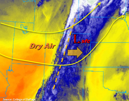
Finally some fall weather to start the day as we near the end of September. Overnight and morning showers are producing lots of cloud cover over the mountains and eastern Colorado. There were even reports of snow over 11,000 feet last night. Temperatures have dropped to more seasonal values in the wake of the cold front, which is very much welcomed after the last heat wave. The main axis of the trough (and moisture) will continue to move eastward today, which means the line of showers will travel eastward as well. That should bring some stronger showers and thunderstorms to the southeast corner of the state and eastern Raton Ridge early this afternoon. Light showers and weaker thunderstorms will be possible over the eastern plains north of Prowers County. A bit of moisture is also able to hold on over the far northeast corner of the state. A surface low in the area is expected to produce a line of convergence on its northeast side, so some isolated thunderstorms will be possible near the NE/CO border.
Behind the trough, much drier air will work its way into the state with WNW flow aloft as evidenced by clear skies over the Utah/Colorado border. Dew points are forecast to quickly drop off starting this morning, so expecting clouds to clear west to east as the dry air mass moves eastward. The clearing skies will also allow temperatures to the west to begin to increase, so it should be a beautiful afternoon and evening. The entrainment of the dry air will limit rainfall chances over the higher terrains this afternoon though a couple isolated high-based showers possible. Storms that do initiate will likely form along the southern Continental Divide, but totals will remain under 0.1 inches. The Southeast Mountains will get a bit more rainfall today as the moisture plume is still over this region. These storms should end as the plume moves east by early afternoon. Flooding is not expected today.
As the trough passes to the north today, increased surface winds are anticipated over the northern third of the state. With dew points dropping off rapidly, enhanced and possibility critical fire weather will be present this afternoon through this evening. Surface wind speeds are forecast to be in the 15 to 25mph range with gusts up to 40mph possible over the higher terrains.
Today’s Flood Threat Map
For more information on today’s flood threat, see the map below. For Zone-Specific forecasts, scroll below the map.

Zone-Specific Forecasts:
Urban Corridor, Palmer Ridge, Northeast Plains, Southeast Plains, Raton Ridge, Front Range, Southeast Mountains:
Drying will occur from west to east today as the trough passes through the area. This should bring some clear skies to the west later this morning and afternoon. The stronger showers and thunderstorms today should be confined to the far eastern plains though some weaker storms will be possible over the Southeast Mountains and Raton Ridge as the line of convection moves eastward. Max 1-hr rain rates up to 0.5 inches will be possible over the Raton Ridge. Stronger thunderstorm activity is forecast over the southeast corner of the state where some decent instability is able to build. Fairly quick steering winds should keep totals from reaching flood threat criteria. Max 1-hr rain rates up to 1.25 inches with small hail and gusty winds are possible. An isolated storm or two is also possible near the CO/NE border associated with a surface low. Max 1-hr rain rates up to 0.9 inches are possible with these storms along with small hail and gusty winds. Flooding is not expected.
Primetime: 10AM to 8PM
Northern Mountains, Northwest Slope, Central Mountains, Grand Valley, San Juan Mountains, Southwest Slope, San Luis Valley:
Drier air is being entrained from the WNW after the passage of the trough. Increased subsidence and low dew points should keep rainfall chances minimal today. It will be possible for some light, isolated showers over the higher terrains near the southern portion of the Continental Divide this afternoon. However, totals are expected to be under 0.1 inches with some brief wind possible, too. Surface winds will increase over the northern third of the state with the passing upper-level jet, so enhanced and possibly critical fire weather will be present in this region. Wind speeds are forecast to be in the 15 to 25 mph range with gusts up to 40 mph possible over the northern high terrains. Clear skies with the entrainment of the dry air will allow temperatures to increase this afternoon with highs over the lower elevations reaching 80F. Flooding is not expected.
Primetime: 2PM to 7PM