Issue Date: Wednesday, September 19th, 2018
Issue Time: 09:50AM MDT
— Flooding is NOT expected today
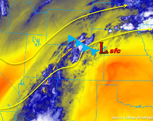
Changes to the weather are finally on their way, which should bring a more fall-like feel to the state after today. The 500mb high has shifted to the east and the trough to our west will start to move into the Great Basin. This pattern has pulled up a plume of subtropical moisture northward (see water vapor imagery below), which will work its way into western Colorado throughout the day. The plume of moisture will then transition east throughout the day and into tomorrow with the axis of the trough. The shortwave marked in the image below will help promote widespread shower and thunderstorm activity this afternoon and evening as it moves eastward. Also noted on the water vapor imagery below is a weak cold front over the Northeast Plains. This feature will sag southward throughout the day and increase low-level moisture a bit behind it. This should bring higher rainfall totals to northeastern Colorado. The main cold front (further north) will begin to drop south through the state this evening. This will help promote showers and thunderstorms overnight for the eastern plains and bring a cool, cloudy start to Thursday morning.
Precipitable Water (PW) values at Grand Junction are currently at 0.51 inches, so forecasting an increase as the plume moves north with the highest PW values expected over the southwest corner of the state. This means showers and thunderstorms will begin as high-based storms later this morning with more wetting rains starting this afternoon. Storms will be oriented southwest to northeast aligned with the positive tilt of the trough. This means more widespread rainfall over the southwest corner with storms confined to the higher terrains as you move north. As the trough begins to move east today, the upper-level jet will position itself over the northwest corner of the state, which should keep the moisture to the south and east of the Northwest Slope. Low relative humidity values with surface winds in the 20-25 mph range will produce critical fire weather. A Red Flag warning is in place through this evening with gusts up to 40 mph possible over the Northwest Slope.
Low-level moisture is also forecast to return over eastern Colorado as the shortwave travels eastward. This moisture should be confined to the Southeast Mountains, Front Range, Urban Corridor, Palmer Ridge and Northeast Plains. Similar to western Colorado, storms will be oriented southwest to northeast with steering winds moving storms along around 15 knots to the northeast, which should keep storms from dropping too much rainfall over one area. First expecting storms to fire over the mountains and then push into the adjacent plains in the evening hours. Storms will then spread into the eastern plains overnight. Models aren’t showing much instability this afternoon likely due to cloud cover increasing throughout the day in front of the trough. This will be another factor that will help keep rainfall intensities below flood threat criteria. Still, 500-900 J/kg of CAPE (measure of instability) should be enough for some decent showers and thunderstorms over the Urban Corridor and Northeast Plains. Storms over the eastern plains tonight are not expected to be severe or meet flood threat criteria, but should instead bring some beneficial rainfall. Localized totals near 1.3 inches are possible by Thursday morning. Flooding is not expected for Wednesday, though rainfall will be widespread.
Today’s Flood Threat Map
For more information on today’s flood threat, see the map below. For Zone-Specific forecasts, scroll below the map.
Zone-Specific Forecasts:
Northern Mountains, Northwest Slope, Central Mountains, Grand Valley, San Juan Mountains, Southwest Slope, San Luis Valley:
Plume of subtropical moisture associated with the eastward movement of the trough will return showers and thunderstorms to the forecast. Storms will begin as high-based over the southwest corner and spread northward throughout the day with northeast movement. Intensity of rainfall is also forecast to increase this afternoon with storms further north confined to the mountains. Max 1-hr rain rates up to 0.5 inches (south) and 0.3 inches (north) are possible with the Central Mountains recording up to 0.75 inches by morning. Localized 2-3 hour totals just under 1 inch will be possible over the eastern San Juan Mountains. Flooding is not expected.
Primetime: 11AM to 2AM
Urban Corridor, Palmer Ridge, Northeast Plains, Southeast Plains, Raton Ridge, Front Range, Southeast Mountains:
Expecting high clouds to increase throughout the day as the shortwave makes it way eastward. This should limit instability, and in return, keep rainfall rates below flood threat criteria. The passage of weak cold front over the Northeast Plains will leave low-level moisture the highest over this area, therefore rainfall totals should be highest here as well. Surface winds should push some of that moisture west this afternoon, which will allow for some heavier rainfall over the Urban Corridor. Storms are expected to be rather widespread over the eastern mountains this afternoon and even the San Luis Valley is expected to get some rainfall. Max 1-hr rain rates up to 0.5 inches are possible over the higher terrains. In the adjacent plains, max 1-hr rain rates up to 0.8 inches are possible due to the increase in low-level moisture. Shower activity is expected to continue overnight as the storms push into the eastern plains and the cold front drops south. Totals up to 1.3 inches will be possible by the morning over the Northeast Plains.
Primetime: 3PM to 11AM