Issue Date: Monday, September 17th, 2018
Issue Time: 1:05 PM MDT
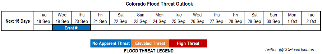
Valid Dates: 9/18 – 10/2
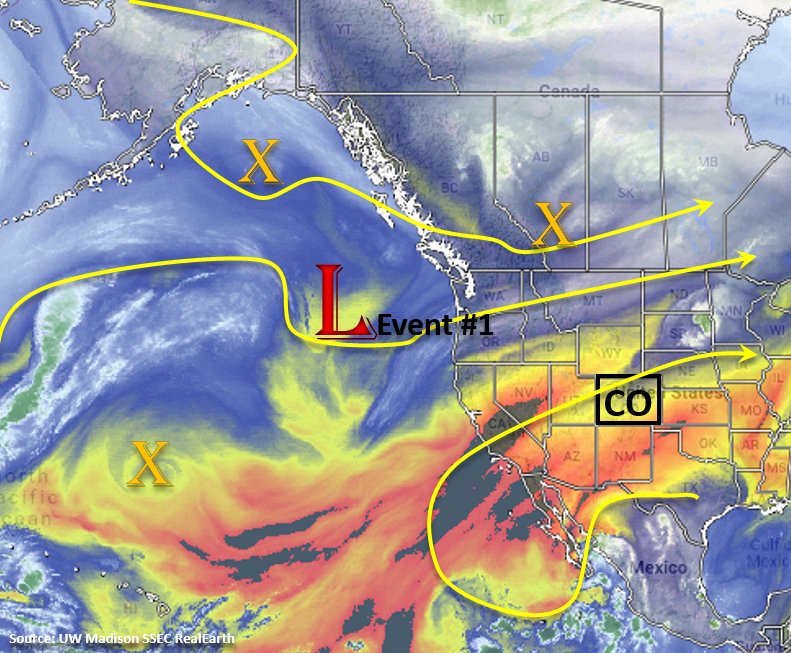
The heatwave will continue for the first part of this week with more seasonal temperatures expected at the end of the week to welcome Fall. The number of 90F+ days in Denver for 2018 is now at 57 days, which is 4th overall in the 150 year record. The reason for the current heat wave is a persistent trough to our west, which is creating a ridging pattern and southwest flow over the state. Dry, warm air is being entrained from the desert southwest and the 500mb high location has been suppressing the better moisture to our south and east. Taking a look at the water vapor imagery below, Event #1 will occur as the trough finally makes it way eastward on Wednesday and Thursday. The eastward movement in the ridge axis should help to pull a bit more low-level moisture into the state, though this is not expected to be a full monsoon surge. Unfortunately, trends in long-term models indicate the weak monsoon season has come to an end. The best chance for some wetting rain this week will be on Wednesday with more limited showers and thunderstorms on Thursday after a more stable air mass moves into the area behind a cold front. At this time there is No Apparent flood threat. Expect temperatures on Thursday to return to more seasonal values. After Thursday, the extremely dry air mass in Nevada (see below) will make its way into Colorado for the weekend. This should again nix the chances for rainfall next weekend, though high temperatures are only expected to be 5-10F above normal. This will be a nice break from the record heat and perfect weather for leaf peeping.
As the trough begins to move eastward, the jet will sag over the northwest corner of the state on Tuesday. Without any mid-level moisture, as seen the last couple of days, critical fire weather is expected with surface winds speeds in the 15-25 mph range over western Colorado. On Wednesday, there should be an increase in moisture with the trough passage, so critical fire weather will likely get downgraded to enhanced fire weather over the Northwest Slope and Central Mountains. After Event #1, the dry air from Nevada (mentioned above) will move into the state, but with the jet to the north and west, critical fire weather is not expected this weekend. By Monday, another trough moves into the Pacific Northwest, which may set up the jet over western and north-central Colorado again. If this occurs, this would bring enhanced and/or critical fire weather back to western and north-central Colorado. Please tune into the FTB for the daily fire outlook as details will likely change.
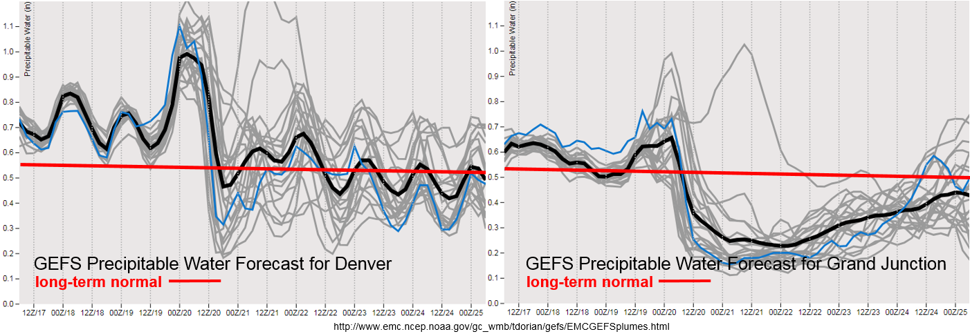
Quite the drastic GEFS moisture plumes below. Still seeing the diurnal signal over eastern Colorado with strong low-level moisture return on Wednesday. Regrettably, this looks to be short-lived with high, post-frontal Precipitable Water (PW) values only remaining over southern and southeastern Colorado on Thursday. There will likely be heavy cloud cover on Thursday morning with spotty rainfall, limiting instability for afternoon storms on Thursday. More seasonal PW values expected after Thursday, which should produce some afternoon cloud cover and possibly some isolated, high-based thunderstorms over the mountains. For western Colorado, PW values look to increase on Wednesday across the southern half of the region associated with the trough passage. This will bring some high-based thunderstorms to the San Juan Mountains capable of gusty winds and dangerous lightning. Increased cloud cover is more likely over the northern high terrains as well on Wednesday. After Wednesday, the extremely dry air mass drops PW values well below normal. This could cause some enhanced and critical fire weather through the beginning of next week.
Below we describe the identified precipitation event of this FTO in more detail.
Event #1: Wednesday (9/19) – Thursday (9/20)
No Apparent Threat as the trough finally moves east and brings fall temperatures to the state.
On Wednesday the upper-level trough begins to move through the area. At this same time, a cold front starts to push through the Northeast Plains. This should help return some low-level moisture with surface winds from the south/southeast for some wetting rains on Wednesday. Expecting afternoon showers to initiate with upslope flow over the eastern mountains and move into the adjacent plains during the early evening. Steering winds look to be fairly quick and moisture only moderate, so not anticipating flooding at this time. The front stalls out over the Palmer Ridge, but has a resurgence on Wednesday night. This means some overnight showers may be possible over eastern Colorado with cloud cover and light showers to start Thursday morning. The passage of the main cold front should bring a cool start to Thursday morning and return high temperatures to more seasonal values. Although the upper-trough passes through fully on Thursday afternoon, a more stable air mass will be in-place. Models are currently showing some weak CAPE over the southern Front Range/Palmer Ridge intersect as well as over the Southeast Mountains, so this is the most likely area for afternoon rainfall activity. It is also possible for some rainfall over the Southeast Plains along a line of convergence associated with the pass trough. Although steering winds will be slower, widespread flooding is not expected at this time due to limited instability. Please tune back into the FTB on Wednesday and Thursday for an update on the rainfall activity as models are showing some variation in timing of the trough and frontal passage. This could affect what areas receive rainfall on Wednesday and Thursday.