Issue Date: Monday, September 17th, 2018
Issue Time: 08:50AM MDT
— Flooding is NOT expected today
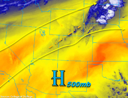
The September heat wave continues for another day as the persistent ridging pattern keeps it hold over Colorado. This means southwesterly winds aloft will remain and entrain dry, warm air from the desert southwest. Marked in the water vapor imagery below is some weak mid-level energy that is carrying a bit of moisture. Currently, this is producing some cloud cover of the northwest corner of the state. This mid-level moisture is expected to help increase cloud cover over the northern half of the state, especially over the higher terrains this afternoon. There is a slight chance for some light rainfall over the Northern Mountains today, though totals will stay under 0.05 inches. Precipitable Water (PW) values at Grand Junction have increased to 0.73 inches, with the majority of the moisture located between 600 and 500mb. This increase in moisture should keep western and north-central Colorado from reaching Red Flag Warning criteria; however, surface winds in the 15-25mph range will created enhanced fire weather through this evening. To the east, PW was measured at 0.53 inches at Denver this morning. This means we can expect cloud cover this afternoon similar to yesterday, which should help knock the edge off the 90F+ temperatures in the immediate adjacent plains. The temperature/dew point spread will remain quite large, so some brief winds may be likely as the clouds evaporate in the low-moisture environment. Over the far eastern plains, some scattered cloud cover is possible, but mostly clear skies are expected. As anticipated, flooding is not expected today.
Today’s Flood Threat Map
For more information on today’s flood threat, see the map below. For Zone-Specific forecasts, scroll below the map.
Zone-Specific Forecasts:
Front Range, Northern Mountains, Northwest Slope, Central Mountains, Southeast Mountains, Grand Valley, San Juan Mountains, Southwest Slope:
Plentiful sunshine today with some cloud cover expected this afternoon. Increased surface winds are expected again today over western and north-central Colorado. Though Red Flag Warning criteria is not expected to be met, 15-25 mph winds should keep enhanced fire weather conditions. A couple high-based showers are possible over the Northern Mountains this afternoon, but totals should remain under 0.05 inches. These storms could also produce some brief winds. Please continue to use caution with any outdoor activities capable of producing a spark.
Urban Corridor, Palmer Ridge, Northeast Plains, Southeast Plains, Raton Ridge, San Luis Valley:
The dry and warm streak continues to start the work week. Expecting above average temperatures again today to flirt with the records. Some brief winds are possible over the adjacent plains/Front Range intersect this afternoon. Also, forecasting some cloud cover to the west, which should help take the edge off the heat later this afternoon. Fire danger will remain elevated with the dry fuels and low relative humidity values, so continue to exercise caution.