Issue Date: Thursday, September 13th, 2018
Issue Time: 11:40 AM MDT
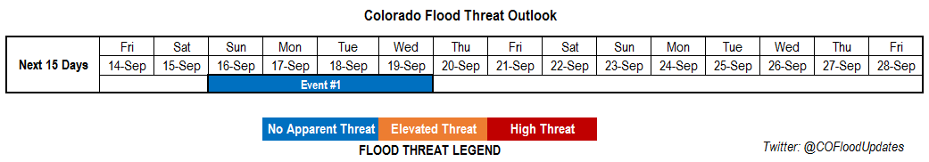
Valid Dates: 9/14 – 9/28
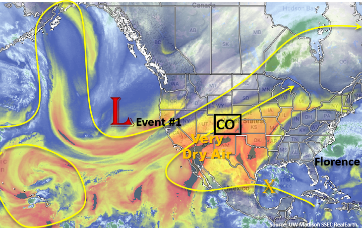
Expecting critical and enhanced fire weather to continue through the beginning of next week. Dry, warm air continues to be entrained from the desert southwest (see the water vapor imagery below) and stronger winds aloft are mixing down to the surface. With relative humidity values in the teens to single digits across the state, conditions are ripe for rapid expansion of fires. Starting Saturday, low-level moisture begins to return to the lower-elevations as the persistent trough to our west begins to move eastward. This should decrease the fire danger some though it take a while for the trough to move east of the area. As the trough moves east, the 500mb flow gradually changes from southwest to more westerly. This will entrain some higher Precipitable Water (PW) values, so by Sunday the critical fire weather should downgrade to enhanced fire weather or no threat.
Also expecting to see showers and thunderstorms to start to return to the forecast from Sunday into Monday as the 500mb high moves into the Texas Panhandle. West of the Continental Divide, showers and weak thunderstorms will be most likely over the San Juan Mountains and near the Divide. Over eastern Colorado, storm coverage from Sunday into Monday is expected to increase over the eastern high terrains. Not expecting much rain from these storms due to lack of low-level moisture and decent steering winds. With adequate temperature/dew point spreads, some gusty outflow winds will be possible. Early Tuesday morning, the GFS is showing a weak cold front moving through the northeast corner of the state. Questionable as to how much moisture will return behind the front, but Tuesday’s temperatures will likely be a bit cooler over this area. Overall, should see an increase in afternoon thunderstorm coverage over northeastern Colorado from Monday into Tuesday. Wednesday, downsloping flow will pick back up, so a downtick in thunderstorm activity is expected as drier air becomes entrained into the low and mid-levels of the atmopshere. Currently, the GFS shows a stronger cold front dropping through the state on Thursday, which if this occurs, will give us our first taste of fall after a long, unseasonable warm stretch of weather. At this time, there is No Apparent Threat for flooding during this FTO period.
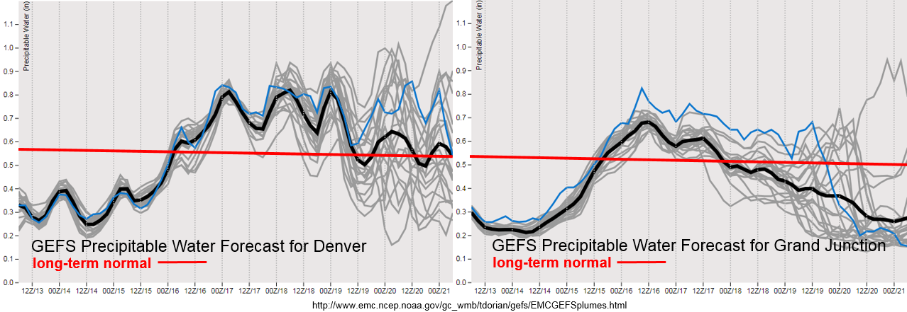
Starting on Saturday night, PW plumes start to show a return to more seasonal moisture values from west to east. This should first cause an increase in cloud cover on Saturday, and then an increase in storm coverage over the higher terrains on Sunday into Tuesday. Low-level moisture doesn’t last long over western Colorado, with a return to below average PW values after Monday. Enhanced/Critical fire danger will likely return to the forecast over this area should PW values drop below 0.4 inches as surface winds are currently forecast to be in the 15-20 mph range. Over eastern CO, there are elevated PW values from Sunday through Tuesday. Quite a bit of spread after this, which likely has to do with how much moisture returns behind the front. Tune back into the FTO on Monday to see how the members are trending for the end of next week. If PW values are able to stay above about 0.5 inches, we will likely still see some scattered storms over the mountains in the afternoon and evening hours on Wednesday and Thursday. If the cold front does drop through on Thursday, snow may be possible over the highest elevations.
Below we describe the identified precipitation event of this FTO in more detail.
Event #1: Sunday (9/16) – Wednesday (9/19)
No Apparent Threat as moisture returns with eastward movement of the ridge for scattered afternoon showers and thunderstorms.
Expecting low-level moisture to increase from the southwest to northeast on Saturday into Tuesday. At first this should only increase cloud cover, but by Sunday and Monday there should also be an increase in shower and weak thunderstorm coverage over the higher terrains. Early Tuesday morning, a cold front may move into the Northeast Plains, which could cause an increase in storm activity over this area during the afternoon. The low-level moisture is short-lived as downsloping winds begin to mix dry air back into the low- and mid-levels of the atmosphere on Wednesday. Expecting enough residual moisture under the ridge for some isolated, high-terrain showers on Wednesday. At this time, unsure about a cold front moving through on Thursday as there is quite a bit of disagreement between GFS members. Should this occur, showers and thunderstorms may be possible (with snow in the highest terrains) over the mountains and adjacent plains on Thursday evening. Please tune back into the FTO on Monday, and for now, we will leave this out of the rainfall map below.