Issue Date: Thursday, September 6th, 2018
Issue Time: 09:30AM MDT
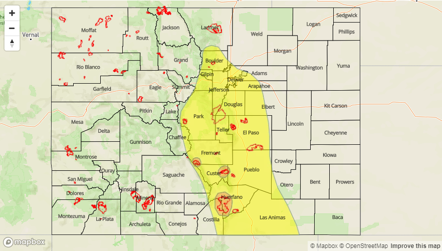
— A LOW flood threat has been issued for portions of the Front Range, Urban Corridor, Palmer Ridge, Southeast Mountains, Southeast Plains, Raton Ridge
— A MODERATE flood threat has been issued for the Spring Creek, Hayden Pass and Junkins burn areas
Upper-level clouds are blanketing the majority of the state with some light rain and fog mixed in to start the morning. Mostly clear skies over the Southwest Slope with some breaks in the cloud cover over western Colorado as some drier air has been entrained from the west. Should be a similar pattern to yesterday with a few minor differences. Current temperatures are in the 50Fs over the lower elevations with upper 30Fs to mid-40Fs over the higher terrains. Warmer temperatures over CO/UT border as the front stalled out before it reached this area.
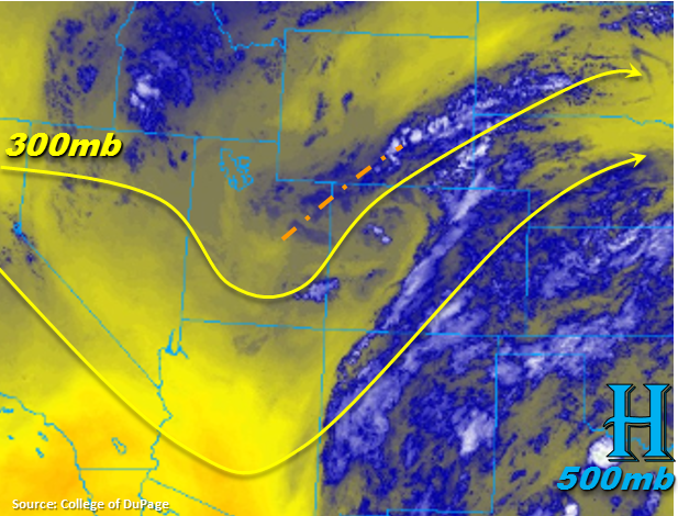
PW this morning was measured at 0.82 inches and 0.85 inches at Denver and Grand Junction, respectively. So not much change in low-level moisture though the water vapor imagery shows some pockets of drier air have moved into western CO. This should cause storms today to be a bit more isolated when compared to yesterday. Also, expecting some gusty outflow winds with storms today (Central/Northern Mountains) as well as there is quite a bit of spread between the temperature and dew points. The greatest coverage will likely be over the San Juan Mountains with more patchy coverage and lower rainfall intensities over the Central and Northern Mountains.
To the east, rinse and repeat pattern of yesterday. Storm motion may look to increase a little, which will mean storms are less likely to produce as much rain as yesterday. However, 15 mph steering winds to the SE will still allow another day of some heavy rainfall. The SW to NE oriented upper-level jet and shortwave marked over the NW corner of the state will help support storms as they move off the mountains. So, storm coverage will likely increase over the adjacent plains this afternoon when compared to yesterday. Storms will decrease north to south this evening starting around sundown with some storms likely over the Raton Ridge/Southeast Plains intersect through midnight.
Burn scars over the SE Mountains will be susceptible to flooding again today, so storms that track near these areas should be monitored closely this afternoon. There is high confidence storms today will have rain rates greater than 0.5 inches/hour, so a Moderate threat has been issued for the Southeast Mountain burn areas. A Low flood threat has been issued for eastern CO again today as heavy rainfall is expected once again and decent rainfall over the mountains yesterday will likely increase runoff this afternoon.
Today’s Flood Threat Map
For more information on today’s flood threat, see the map below. For Zone-Specific forecasts, scroll below the map.

Zone-Specific Forecasts:
Southeast Plains, Raton Ridge, Southeast Mountains, Front Range, Palmer Ridge, Urban Corridor, Northeast Plains:
Rinse and repeat pattern of yesterday with some more action in the adjacent plains this afternoon into tonight. Instability along the Urban Corridor is not expected to be as high today, so not expecting as much hail as yesterday. However, a quick 0.5 inches in a half hour could cause some minor flooding issues in low-lying roads. Over the mountains, small hail and snow above 13,000 feet will be possible. A Low flood threat has been issued as moisture and slow steering winds combine to create pockets of heavy rainfall this afternoon. Saturated soils from yesterday will also increase runoff. A Moderate threat has been issued for the Spring Creek, Hayden Pass and Junkins burn areas. A Low threat for Weston Pass should suffice. If a storm tracks over a burn area, mud flows, debris slides and local stream flooding are possible. 1-hr rain rates up to 1 inch are possible over the higher terrains with max 1-hr rain rates up to 1.2 inches over the Front Range/Urban Corridor intersect.
Primetime: 1PM – 12AM
Grand Valley, Central Mountains, San Juan Mountains, San Luis Valley, Southwest Slope, Northern Mountains, Northwest Slope:
Some pockets of drier air have been entrained from the west, so storm coverage will be more isolated this afternoon when compared to yesterday. Low-level moisture will still allow some decent rain to reach the surface with the most action over the San Juan Mountains. Gusty winds will be possible with the stronger storms to the north. Max 1-hr rain rates up to 0.75 inches (south) and 0.5 inches (north) are possible. Storms should end a couple of hours after the sun sets.
Primetime: 12PM – 10PM