Issue Date: Wednesday, September 5th, 2018
Issue Time: 11:30 AM MDT
Summary:
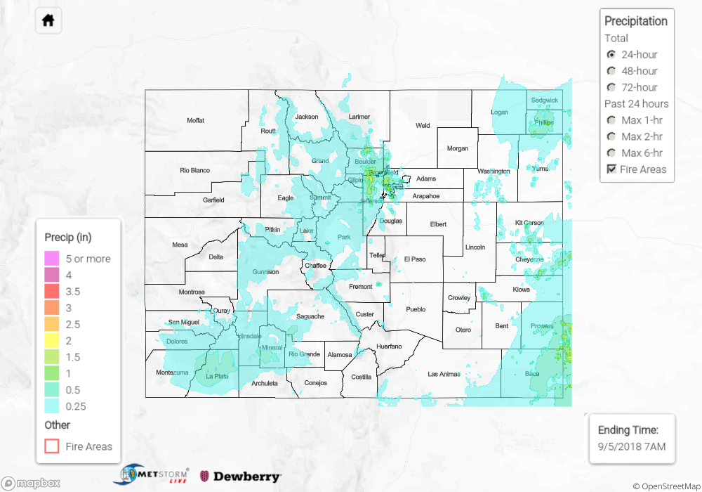
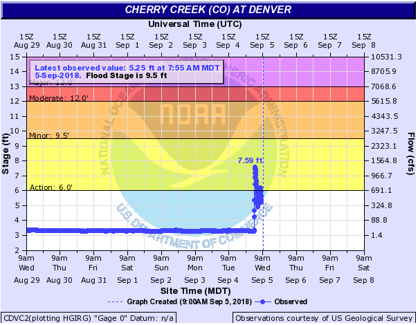
Yesterday began with cooler temperatures and some sun in the afternoon. With enough moisture and primed atmospheric conditions, Tuesday saw thunderstorms develop along the Front Range, Urban Corridor, Palmer Ridge, and the plains areas starting during the afternoon and continuing overnight. Overnight, some of these storms were quite powerful along the east parts of the Front Range and the Urban Corridor. Widespread rainfall values over 1 inch/hour occurred along the Urban Corridor. CoCoRaHS stations from Jefferson County to Weld County recorded total rainfall values over 1 inch, with some up to 2 inches. Heavy rainfall in Denver, Jefferson, and Boulder counties was also reported by the National Weather Service. While no major flooding was observed, river levels near Denver soared as heavy rain swept through. Below shows the Cherry Creek River gauge at Denver rising over 4 feet overnight to a max height of 7.59 feet.
Thunderstorms also occurred out across the western parts of the state, producing rainfall and large wind gusts. From Garfield and Eagle counties and south, spurious thunderstorms produced rainfall totals around 0.25 inches, and gusty winds between 40 and 50 mph. No flooding was reported underneath theses storms.
Click Here For Map Overview
The map below shows radar-estimated, rainfall gage-adjusted Quantitative Precipitation Estimates (QPE) across Colorado. The map is updated daily during the operational season (May 1 – Sep 30) by 11AM. The following six layers are currently available: 24-hour, 48-hour and 72-hour total precipitation, as well as maximum 1-hour, 2-hour and 6-hour precipitation over the past 24 hour period (to estimate where flash flooding may have occurred). The 24-hour, 48-hour and 72-hour total precipitation contain bias corrections that are not disaggregated into the hourly estimates, so there will likely be some differences. The accumulation ending time is 7AM of the date shown in the bottom right corner. Also shown optionally are fire burn areas (post 2012), which are updated throughout the season to include new burn areas. The home button in the top left corner resets the map to the original zoom.