Issue Date: Wednesday, September 5th, 2018
Issue Time: 10:55AM MDT
—A MODERATE flood threat has been issued for portions of the Front Range, Urban Corridor, Palmer Ridge and Southeast Plains. Also for the Spring Creek and Junkins burn areas.
—A LOW flood threat has been issued for the Front Range, Urban Corridor, Palmer Ridge, Southeast Mountains, Raton Ridge and Southeast Plains. Also for the Lake Christine, Hayden Pass and Weston Pass burn areas
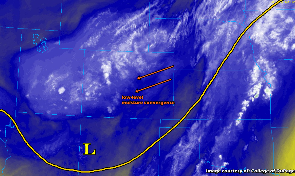
A large, upper-level trough situated over the western United States is creating substantial atmospheric lift throughout Colorado. Meanwhile, a surface high pressure system located over the western Dakotas is pushing humid air from the Great Plains and into the eastern regions of Colorado with low-level southeasterly flow. Areas in the Urban Corridor and Front Range received heavy rainfall overnight, which shows the strong low-level moisture resurgence behind a cold front passage. Low-level moisture is expected to remain high today with dew points already in the low 50s along the Front Range. This humid air is present in atmospheric soundings as well: precipitable water at Denver was measured at 0.83 inches this morning, with these values expected to rise a bit more throughout the day along the Urban Corridor and Palmer Ridge areas.
Upslope flow is expected to initiate showers and thunderstorms over the Front Range and Southeast Mountains this afternoon. With the vorticity max moving north throughout the day, coverage should also increase making storms this afternoon more widespread in nature. Extra convergence along the Palmer Divide will allow storms to remain active as they slowly move off the mountains this afternoon and evening. Storms are not expected to survive too far east of I-25 as the setting sun will decrease instability. It is possible for a few lighter showers to linger over the mountains tonight. Cloud cover this morning may hinder some afternoon convection over certain areas, but skies are already starting to clear. This should allow some moderate instability to build for storms this afternoon. Upper-level steering winds are weak, so slow thunderstorm movement will lead to heavy, localized rainfall totals. Convection may also pose a hail threat, which may exacerbate flooding in urban areas. A Moderate and Low flood threat have been issued. A Moderate threat has also been issued for the Spring Creek and Junkin burn areas with a Low threat for the Weston and Hayden Pass burn areas. With nearly stationary storms and possible back-building, local stream flash flooding, mud flows and debris slides are possible with storms that track over these areas.
For western CO, Moderate rainfall is being reported over portions of the San Juan and Central Mountains with heavy fog in the mountain valleys. There’s also some thunder just west of Pueblo over the Southeast Mountains. Storms are expected to pick up in coverage this afternoon into this evening from south to north. Storms should be widespread in nature with the vorticity max moving north, so expecting the lower valleys to get some rainfall as well. The cloud cover will likely limit instability some this afternoon, so between that and higher-based storms, max 1-hr rain rates should remain flood threat criteria. However, 2-3 hour localized totals around 1 inch are possible. Due to the slow moving nature of the storms, a Low flood threat has been issued for the Lake Christine burn area. If a nearly stationary storm forms over the burn area, flash flooding, mud flows or debris slides may be possible.
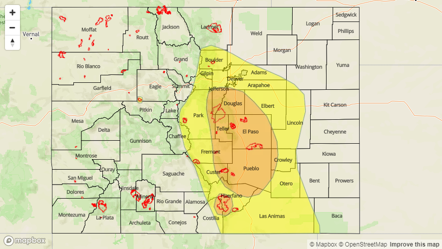
Today’s Flood Threat Map
For more information on today’s flood threat, see the map below (hover over threat areas for more details). For Zone-Specific forecasts, scroll below the map.
Moderate Flood Threat Today

Zone-Specific Forecasts:
Southeast Plains, Raton Ridge, Northeast Plains, Southeast Mountains, Front Range, Palmer Ridge, Urban Corridor:
Showers and thunderstorms are anticipated to build over the Front Range and Southeast Mountains late this morning/early afternoon and over into the Urban Corridor, Palmer Ridge, Raton Ridge and the Southeast Plains during the afternoon. High low-level moisture along with the slow-moving nature of the storms will produce heavy rainfall. Max 1-hour rainfall rates up to between 1 inch (west) and 1.4 inches (east) should be expected. Localized 24-hour totals near 2.5 inches are possible over the Moderate threat area. The Northeast plains will likely stay capped today after the frontal passage, but some rain is possible over the Southeast Plains. Unlike your typical pattern where storms move east of the mountains into the Southeast Plains, today some showers and thunderstorms could move in from the east. Max 1-hr rain rates up to 1.1 inches/hour possible.
Primetime: 12PM to 2AM
Grand Valley, Central Mountains, San Juan Mountains, San Luis Valley, Southwest Slope, Northern Mountains, Northwest Slope:
Morning rain and cloud cover over most of this region will continue into the afternoon, which should limit instability and 1-hour rainfall intensities this afternoon. With higher-based storms, gusty winds will come into play underneath stronger storms. Rainfall rates are expected to remain generally below 0.5 inches/hour, though isolated max 1-hr totals up to 0.9 inches are possible. Due to the nearly stationary rainfall this afternoon, a Low flood threat has been issued for the Lake Christine burn area as there is high confidence storms in the area will exceed 0.5 inches in 1 hour.
Primetime: 11AM to 11PM