Issue Date: June 11th, 2015
Issue Time: 10:25 AM
— Moderate flood threat for Front Range, Urban Corridor, Palmer Ridge, parts of Northeast Plains, parts of Southeast Plains
— Low flood threat for remaining part of the state except San Luis Valley and extreme northeast
NOTE: Depending on how weather conditions progress, there may be an update to the flood threat by 3pm today. Of special interest will be the potential continuation of flood threat into the overnight hours for the Southeast Plains.
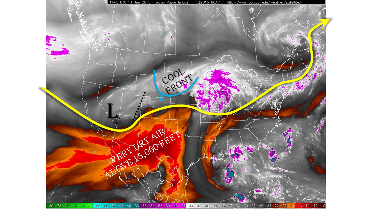
The upper-level that has been causing an active stretch of weather is finally knocking on our door. This is shown by the water vapor image, below. While the center of circulation is over Nevada and Utah, a disturbance is noted on the Colorado / Utah border. This disturbance is already sparking off shower and thunderstorm activity over the Northwest Slope. Meanwhile, conditions near the surface remain very moist for the entire state. Dewpoint temperatures are in the 50s to near 60, while precipitable water values continue to run high, at or above 1 inch for Boulder, Pueblo and Grand Junction alike. The water vapor imagery also shows the continuing presence of the very dry air aloft. However, this air is expected to scoot south and east, out of the state, and it will only minimally impact storm activity. Finally, surface observations depict an impressive cool front, by summer standards, over eastern WY and western NE.
Today, we expect thunderstorm activity to quickly ramp up statewide, with action generally beginning in the north and then progressing south and eastward. The aforementioned cool front will play a very large role in dictating the duration of the heavy rainfall threat. We expect that the cool front will enter the northeast quadrant of the state by mid-afternoon, and beginning to disrupt storm activity. Nonetheless, before the front’s entrance, there will be a 4-5 hour window of very heavy rainfall east of the Divide. A Moderate flood threat has been posted for many areas. West of the Divide, thunderstorm activity will be slightly less potent but still capable of producing short-term heavy rainfall. A Low flood threat is posted here.
While the main flood threat today will subside after sunset, lighter rainfall will continue, especially east of the Divide into the night time hours. Rain rates are expected to remain below 0.5 inches per hour, limiting the flood threat.
Today’s Flood Threat Map
For more information on today’s flood threat, see the map below (hover over threat areas for more details). For Zone-Specific forecasts, jump below the map.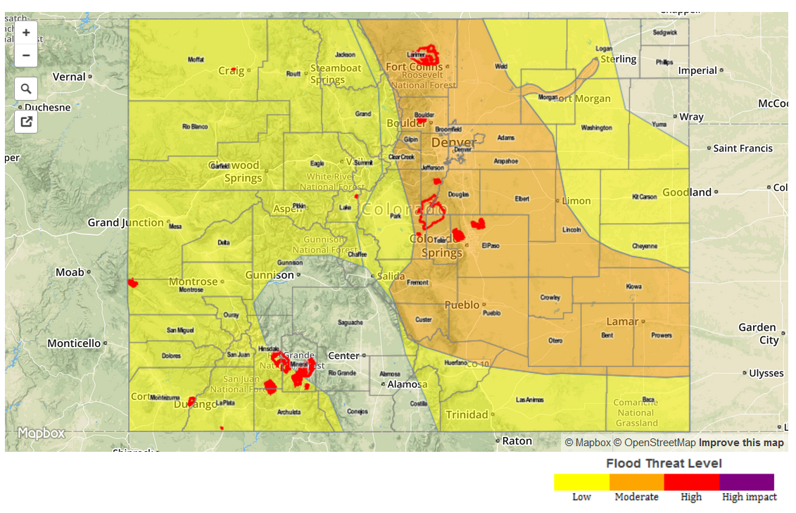
Zone Specific Forecasts
Front Range, Urban Corridor, Northeast Plains, Palmer Divide, Southeast Plains, Southeast Mountains and Raton Ridge:
Partly cloudy skies with thunderstorms developing by early afternoon. Activity will start in the north and quickly spread southward. One hour rain rates up to 2.4 inches will be possible and 3-hour rain rates up to 3.5 inches. Storm motion is expected to be slowest along the foothills, with faster motion away from the mountains. Over and south of the Palmer Ridge, storms will also be capable of producing hail up to 1.5 inches and wind gusts up to 60 mph. A Moderate flood threat is in place for a majority of the area, with a Low flood threat elsewhere. The strongest activity will subside shortly after sunset, but moderate rainfall, up to 0.7 inches per hour, is possible through midnight.
Primetime: 1pm through 9pm for the Moderate, 12pm through midnight for the Low.
Central Mountains, Northern Mountains:
Mostly cloudy skies with showers and thunderstorms developing by early afternoon. One hour rainfall up to 1inch per hour is possible. This, combined with remaining snowmelt warrants a Low flood threat through the late evening hours. Debris slides and mud flows will be possible in the vicinity of stronger storms.
Primetime: 12pm through 8pm
Grand Valley, Northwest Slope, San Juan Mountains, Southwest Slope and San Luis Valley:
Partly to mostly cloudy with numerous showers and thunderstorms continuing through the early evening. One hour rainfall up to 1.25 inches possible, resulting in localized flash flooding, debris flows and mud slides. A Low flood threat is in place for all except the San Luis Valley.
Prime time: 11am through 8pm