Issue Date: Friday, August 17th, 2018
Issue Time: 09:35 AM MDT
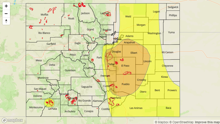
— A MODERATE flood threat has been issued for portions of the Front Range, Urban Corridor, Palmer Ridge, Southeast Plains and Southeast Mountains
— A LOW flood threat has been issued for the Front Range, Urban Corridor, Northeast Plains, Palmer Ridge, Southeast Plains, Raton Ridge and Southeast Mountains, 416/Burro burn scar
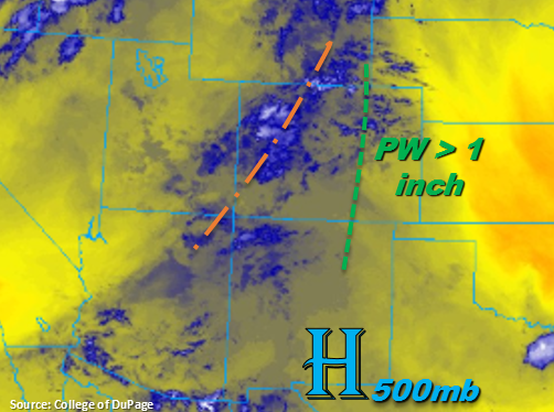
Another shortwave is rotating its way around the high pressure, which is helping spark some light showers and cloud cover over western Colorado. More dense clouds to the north should limit the amount of instability that can build over the area for this afternoon, so not expecting storms to be as convective. However, still expecting shower coverage to pick up through the early afternoon. Further south over the San Juans, breaks in the high clouds will allow a little more instability to build, which should result in a little higher rain rates and stronger thunderstorms this afternoon. Overall, fairly widespread, garden variety showers and thunderstorms are forecast over the over the higher terrains through this evening for western Colorado. With slow steering winds and increased moisture associated with the shortwave, the flood threat returns to the 416 and Burro burn areas. A Low flood threat has been issued with threats including mud flows, debris slides and local flash flooding of streams for storms that track directly over the burn scars.
Over eastern Colorado, there is some moderate to dense fog over the southwest corner of the state and far eastern plains. This indicates that low-level moisture is still quite high over the area. Southeasterly surface flow today should begin to return moisture further north. Denver’s sounding this morning shows PW values at 0.91 inches, which is the 80th percentile for this time of year and quite an increase since last night (0.72 inches). Instability should be able to build throughout the morning and early afternoon and the shortwave is expected to arrive over eastern Colorado around peak heating coinciding with the diurnal flow. This should return the chances of showers and thunderstorms to the Southeast Mountains, Raton Ridge and Palmer Ridge. Thunderstorms are also expected fire over the Front Range today.
As storms move off of the higher terrains into the adjacent plains this afternoon, they will be moving into an area with dew points in the mid to upper 50Fs. With slow steering winds aloft and little shear, storms will be pulse-like in nature with outflow boundaries helping to trigger additional storm development. Threats today include gusty winds, small hail and heavy rainfall. As the storms move east of I-25, it is likely they will form a mesoscale convective system (MCS), which will be capable of producing widespread, heavy rainfall overnight. This system will slowly move eastward and exit the state by 1 or 2AM. Slow steering winds and high surface moisture also means there is a flood threat for recent burn scars. All recent burn scars over the eastern mountains should be monitored carefully this afternoon and evening. There has been a Moderate and Low flood threat issued today. Threats include mud flows, debris slides and arroyo flooding over the higher terrains with local stream flooding, field ponding and road flooding threats over the lower terrains.
Today’s Flood Threat Map
For more information on today’s flood threat, see the map below. For Zone-Specific forecasts, scroll below the map.

Zone-Specific Forecasts:
Southeast Plains, Raton Ridge, Southeast Mountains, Front Range, Palmer Ridge, Northeast Plains, Urban Corridor:
High low-level moisture over the eastern plains will pair with an upper disturbance to bring widespread shower and thunderstorm coverage over the eastern high terrains. As the storms move off of the mountains, they will encounter dew points in the mid to upper 50Fs. Slow steering winds and a complex of thunderstorms along and just east of I-25 will make widespread, heavy rainfall the main threat today and tonight. Max 1-hour rain rates over the higher terrains up to 1 inch (southern) and 0.3 inches (northern) are possible. Over the adjacent plains max 1-hr rain rates could reach 1.75 inches. Localized totals over 2-3 hours exceeding 2 inches over the adjacent/eastern plains are possible. Threats include road flooding, field ponding and local stream flooding. Burn scars should also be watched closely this afternoon with slow steering winds aloft. A Low and Moderate flood threat have been issued. This is an overnight threat for the eastern plains.
Primetime: 1PM – 2AM
Grand Valley, Central Mountains, San Juan Mountains, San Luis Valley, Southwest Slope, Northern Mountains, Northwest Slope:
Garden variety of storms over the western higher terrains are forecast today with increasing coverage after the noon hour. High clouds again over the area this morning associated with a disturbance that moved in from the west. This should limit the more convective rain to the San Juan Mountains. Threats today include gusty winds and possibly some small hail (south). Slower steering winds will again return the flood threat to the 416/Burro burn areas. Max 1-hour rain rates up to 0.75 inches (south) and 0.5 (north) are possible. A Low flood threat has been issued for the 416/Burro burn areas.
Primetime: 11:30AM – 8PM