Issue Date: Thursday, August 16th, 2018
Issue Time: 09:00AM MDT
— A LOW flood threat has been issued for the 416/Burro and Spring Creek burn areas
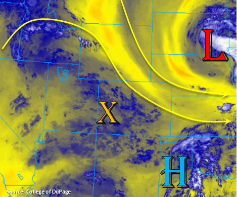
Rinse and repeat pattern for this Thursday. The low pressure continues to slowly move to the east and drier air has been entrained into northern Colorado in its wake. Currently, there is some ongoing fog over the Northeast Plains, but it will begin to break up quickly with the morning heating. Smoke and haze being reported over western Colorado along with some high and mid-level cloud cover associated with a disturbance rotating around the high. Today, the 500mb ridge begins to build to the north of Colorado. This will create light northwesterly flow aloft over the state.
Not much change in the low-level moisture, so there will be enough residual moisture under the ridge to fire another round of showers and thunderstorms over the southern higher terrains. Expecting coverage to ramp up over the Central and San Juan Mountains into the early afternoon as more upper-level energy rotates around the 500mb high in tandem with the diurnal flow and a little bit more low-level moisture. Later this afternoon, this disturbance will move east and help increase coverage over the Southeast Mountains and Raton Ridge. With slower steering winds today, rainfall totals over an area are expected to increase. The majority of the activity will be over the San Juan Mountains, along and near the Continental Divide and over the Southeast Mountains/Raton Ridge. Some more isolated storms are expected over the southern Front Range and Palmer Ridge. Moisture won’t be quite as high further north, so expecting totals to decrease and gusty outflow winds to increase. There is also a slight chance for some thunderstorms over the Southeast Plains thanks to a surface low in the area. Better moisture will be to the east of this surface trough, so 1-hour rain rates should stay under flood threat criteria once again.
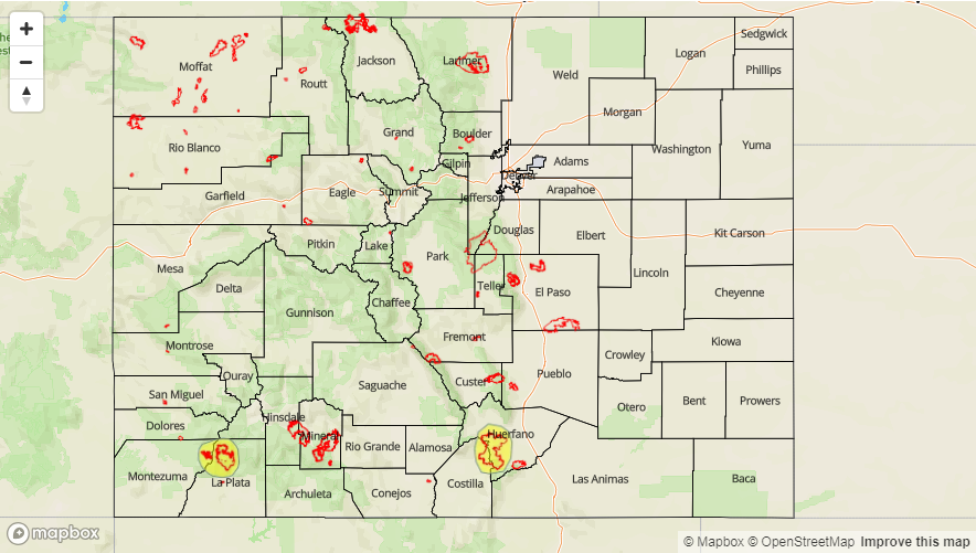
With slower steering winds aloft and increased coverage over the San Juan Mountains this afternoon, there is higher confidence storms in the area will have rain rates exceeding 0.5 inches/hour. It is also feasible for some localized 24-hour totals up to 1 inch, which could cause issues if this occurs over the recent burn scars. There is less confidence 1-hour rain rates will reach this threshold over the Southeast Mountains, but again, slow steering winds make this scenario more plausible. A Low flood threat has been issued for the 416/Burro fire and the Spring Creek fire. Threats include mud flows, debris slides and flash flooding of local streams for storms that track directly over the burn scars. The threat should end a couple of hours after sundown, but a few showers could linger over the higher terrains and Southeast Plains tonight.
Today’s Flood Threat Map
For more information on today’s flood threat, see the map below. For Zone-Specific forecasts, scroll below the map.

Zone-Specific Forecasts:
Grand Valley, Central Mountains, San Juan Mountains, San Luis Valley, Southwest Slope:
High clouds over the area associated with a disturbance that moved in from the west. A lot of haze and smoke being reported this morning, which should stick around today. Storms are forecast to increase through the early afternoon with the San Juans and along/near the Continental Divide receiving the majority of the rainfall with a slight increase in low-level moisture. Threats today include gusty winds and small hail. Slower steering winds should increase totals. Max 1-hour rain rates up to 0.75 inches are possible. Localized 24-hour totals near 1 inch are also plausible over the San Juan Mountains. A Low flood threat has been issued for the 416/Burro burn areas. Some light showers may linger over the high terrains into tomorrow morning, but the flood threat should end a few hours after sundown.
Primetime: 11:30AM – 11PM
Southeast Plains, Raton Ridge, Southeast Mountains, Front Range, Palmer Ridge:
With a similar pattern to yesterday, showers and thunderstorms will return to the southern high terrains this afternoon. Decreased moisture to the north will limit rain rates with higher rain rates over the Southeast Plains due to increased low-level moisture. An isolated severe storm is possible over the Southeast Plains with small hail and gusty winds being the main threats. Some showers may linger over the Southeast Plains through 2AM. Max 1-hour rain rates up to 0.7 inches (SE Mountains/adjacent plains), 0.5 inches (Front Range) and 1 inches (SE Plains) are possible. A Low flood threat has been issued for the Spring Creek burn area.
Primetime: 1PM – 9PM
Northeast Plains, Northern Mountains, Northwest Slope, Urban Corridor:
Arid air associated with the passing trough will again nearly eliminate the chances for measureable rainfall this afternoon. High clouds will increase over the higher terrains this afternoon when compared to yesterday. It is possible for a few light showers over the Northern Mountains/Northwest Slope near the Roan Plateau, but totals are expected to be under 0.1 inches. Smoke will continue to inundate the area and reduce visibility throughout the day. Tomorrow morning the near surface smoke looks to decrease a bit when compared to this morning. Expecting high temperatures to be similar to yesterday.