Issue Date: Monday, August 13th, 2018
Issue Time: 08:50AM MDT
— Flooding is NOT expected today
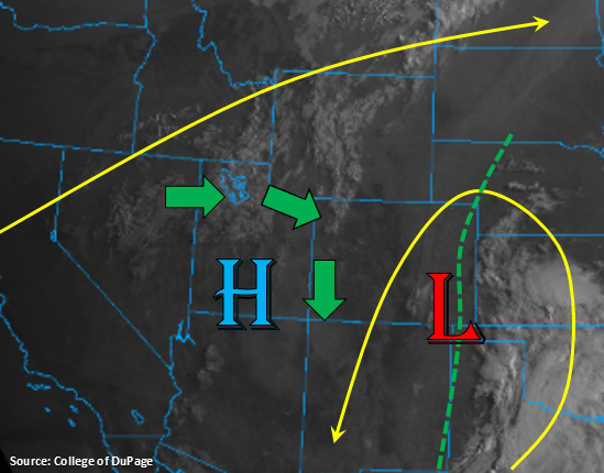
Some scattered clouds to start the week over the Northwest Slope associated with the trough passing to the north today. The visible satellite picture also shows a bit of fog along the Urban Corridor and eastern plains thanks to the upper-level low over the southeast corner of the state. The low is also generating some moderate to heavy rainfall to our east over KS, OK and TX as it pulls in abundant subtropical moisture from the Gulf of Mexico. Some of this moisture may be pulled in to the far eastern plains today, but shouldn’t make it further west than the dashed green line. Thus, some showers and thunderstorms are possible over the Southeast Plains through this afternoon and tonight. With storm motion to the S/SW at 20-25 mph, flooding is not expected.
The center of widespread, thunderstorm action today will be over western Colorado with the bulk of the action occurring over the Northern, Central and San Juan Mountains. Moisture is not expected to be ample, but some additional low-level moisture will be transported around the high into western Colorado. There’s also upper-level energy passing around the high that will bring storm chances to the lower valleys. With a large temperature and dew point spread, the main threats today will be gusty wind and dangerous lightning. Slightly higher low-level moisture is forecast over the southern San Juan Mountains, so 24-hour totals will be greatest over this area. This slightly higher moisture may also creep into far southern Southeast Mountains. So for the eastern mountains, storm chances will be greatest over this area and along the Continental Divide. Flooding is not expected today, and storms are expected to end a couple of hours after nightfall.
Today’s Flood Threat Map
For more information on today’s flood threat, see the map below. For Zone-Specific forecasts, scroll below the map.
Zone-Specific Forecasts:
Northern Mountains, Northwest Slope, Grand Valley, Central Mountains, San Juan Mountains, San Luis Valley, Southwest Slope:
Storm activity should be relatively widespread today, which includes the lower valleys. The strongest storms are still expected over the higher terrains with storm motion to the south. The highest low-level moisture is forecast over the southern San Juans, so expecting the highest 24-hour values along the CO/NM border. A few storms may wander into the San Luis Valley that form over Saguache County. Threats today include strong outflow winds, small hail and dangerous lightning. Max 1-hour rain rates up to 0.4 inches (north) and 0.75 inches (south) are possible. Flooding is not expected.
Primetime: 1PM – 11PM
Northeast Plains, Southeast Plains, Urban Corridor, Raton Ridge, Southeast Mountains, Front Range, Palmer Ridge:
The low pressure over the southeast corner of the state may help pull in some higher low-level moisture values over the far eastern plains. There is a slight chance for some afternoon thunderstorms along a line over convergence in this area. With quick storm motions (20-25 mph) to the S/SW, widespread flooding should be sidestepped. Guidance hints at outflow boundaries from the KS convection possibly sparking some late night storms over the Southeast Plains as well. Isolated max 1-hour rain rates up to 1 inch are possible. Over the higher terrains, storm action should be confined to and along the Continental Divide and over the Southeast Mountains near the CO/NM border. Max 1-hour rain rates up to 0.3 inches are possible with most areas receiving 0.15 inches or less. Flooding is not expected.
Primetime: 1PM – 4AM