Issue Date: Wednesday, August 8th, 2018
Issue Time: 09:00AM MDT
— A LOW flood threat has been issued for the Spring Creek, Hayden Pass and Junkins burn scars
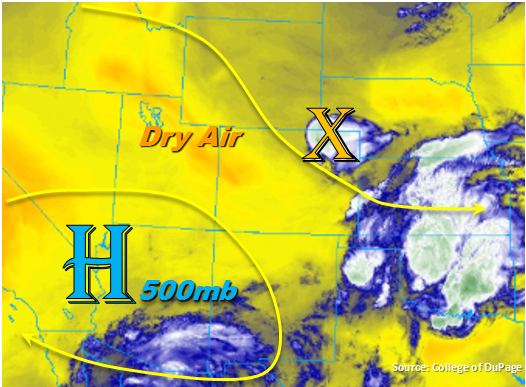
The center of the 500mb high begins its migration to Nevada today. As the ridge builds over the Pacific Northwest, dry air will begin to be entrained into the state with more of a northerly flow aloft. This will also keep the subtropical moisture south of Colorado. This is expected to reduce the thunderstorm activity this afternoon; however, there is enough residual moisture under the ridge to initiate storms over the higher terrains. Currently, a shortwave over the Northeast Plains helped provide lift for some overnight thunderstorm and shower activity and is marked with the orange “X” below. This disturbance will linger to the south/southeast over the plains through the early afternoon before eventually making its way into Kansas. Moderate rainfall and thunder are being reported now along with gusty winds and small hail, but flooding is not expected with these storms. With high dew points in the area (60F+), localized totals up to 1.4 inch are possible.
With more of a northerly flow aloft, storms separate from the ongoing plains convection, should be confined to the mountains with isolated activity over the adjacent plains. The Denver sounding this morning showed moisture beginning to drop, and PW was measured at 0.88 inches. Thus, the most likely area for thunderstorm development this afternoon is along the southern Front Range, Southeast Mountains and Palmer/Raton Ridges. Though some more isolated, short-lived storms are possible further north. Storm motion will be to the south at about 15-20 mph, so widespread flooding is not expected. Over western Colorado, dry air and the 500mb high confining subtropical moisture south, should nix the chances for measurable rainfall again this afternoon.
Fresh burn scars over the Southeast Mountains will be susceptible to mud flows and debris slides this afternoon. It can take as little as 0.5 inches/hour to trigger the aforementioned threats and flash flooding if a storm tracks directly over a scar. Due to rain rates up to 0.8 inches/hour being possible, a Low flood threat has been issued for the Junkins, Hayden Pass and Spring Creek burn areas. Elsewhere, flooding is not expected.
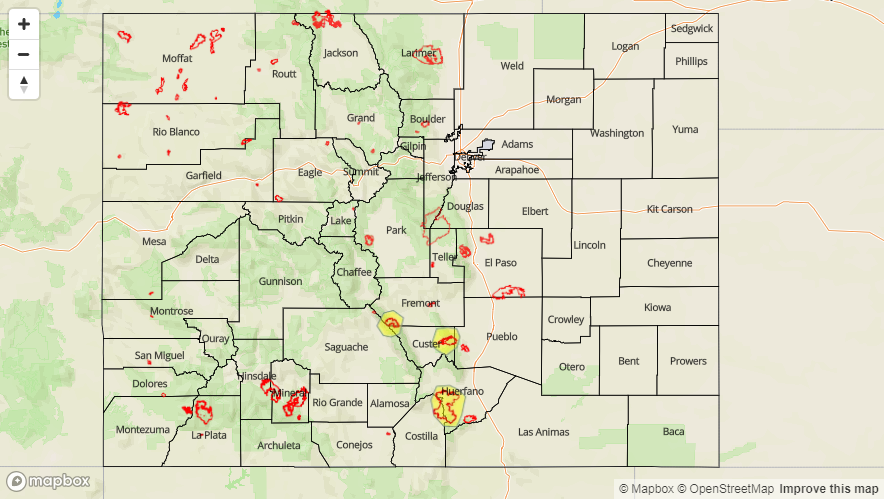
Today’s Flood Threat Map
For more information on today’s flood threat, see the map below. For Zone-Specific forecasts, scroll below the map.

Zone-Specific Forecasts:
Southeast Mountains, Raton Ridge, Urban Corridor, Northeast Plains, Front Range, Palmer Ridge, Southeast Plains:
Ongoing convection on the plains will continue through early this afternoon. Dew points in the 60Fs will promote heavy rainfall, but storm motion should prevent flooding. Max 1-hour precipitation rates should stay below flood threat criteria, though localized storm totals up to 1.4 inches are possible. Small hail and gusty winds are also possible. To the west, expecting convection to initiate over the higher terrains again this afternoon. Southerly storm motion should keep the storms over the mountains with isolated activity over the adjacent plains. Max 1-hour rain rates up to 0.5 inches (north) and 0.8 inches (south) are possible. A Low flood threat has been issued for the recent burn scars over the Southeast Mountains.
Primetime: 1PM – 10PM
Northern Mountains, Northwest Slope, Central Mountains, Southwest Slope, San Juan Mountains, San Luis Valley, Grand Valley:
Starting to heat up some more today, though hazy conditions from the smoke will likely knock down high temperature a couple degrees. The latest HRRR run indicates that the northerly flow aloft will start to cut off the inflow of smoke overnight. However, it will stick around to limit visibility today. Rainfall chances are slim to nil over the higher terrains today, though some cloud cover is expected this afternoon.