Issue Date: Tuesday, August 7th, 2018
Issue Time: 09:30AM MDT
— A MODERATE flood threat has been issued for the Spring Creek, Hayden Pass and Junkins burn scars
— A LOW flood threat has been issued for Palmer Ridge, Southeast Mountains, Raton Ridge and portions of the Southeast Plains, Front Range and Urban Corridor
Fog can be seen on the visible satellite imagery below, but that should burn off fairly quick this morning as heating occurs. The lack of cloud cover means that instability will be able to build again for another round of severe thunderstorm activity this afternoon. The upper-level high pressure center remains elongated over CA/AZ/NM/TX with a little northward movement today. Similar to yesterday, storms will be confined to the eastern half of the state and favor the southern Front Range, Palmer Ridge and Southeast Mountains for initiation under upslope flow. Also expecting some thunderstorms to fire off the Cheyenne Ridge, and an isolated storm or two may move into the Northeast Plains by the early evening.
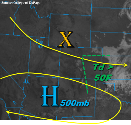
As far as the dynamical set up, looking at something similar to yesterday with a few minor differences. Another shortwave is expected to move through the area this afternoon, but it is not quite as strong as yesterday and may not reach eastern Colorado at peak heating. This would reduce the widespread thunderstorm activity over the adjacent, eastern plains. Instability will drop off a bit, but shear will increase some. The 12Z sounding shows the freezing level has dropped, which brings back the threat of large hail. In regards to low-level moisture, dew points remain high again today with the area beneath and to the east of the green line at least in the 50Fs. The Southeast Plains and Raton Ridge already have dew points in the 60Fs, which is extremely high for August. Some of this surface moisture may mix out, but steady east/southeast surface flow would only allow the dew points to drop off by a couple of digits at the most. Overall, the atmospheric environment is more than sufficient for some large, severe thunderstorms again this afternoon.
Threats for Tuesday include large hail, damaging winds and heavy rainfall. Guidance shows the heavy rainfall threat should remain south of the Palmer Ridge. While storm motion will be fairly quick to the southeast, saturated soils from yesterday may help to increase runoff and field ponding over the adjacent plains. There is also an increased threat for any storms that track over urban areas as the impervious surfaces will increase runoff and ponding in low-lying areas. The southern Southeast Mountains look a bit more active today when compared to yesterday, which will put recent burn scars at risk for flash flooding. A Moderate flood threat has been issued for the Spring Creek, Junkins and Hayden Pass burn scars due to high confidence rainfall rates in the area will exceed 0.5 inches/hour. Mud flows, debris slides and flash flooding of local streams are all possible for storms that track over these areas, or for any heavy rainfall over high terrains. A Low flood threat has been issued for the Front Range, Urban Corridor, Northeast Plains and Southeast Plains.
Today’s Flood Threat Map
For more information on today’s flood threat, see the map below. For Zone-Specific forecasts, scroll below the map.


Zone-Specific Forecasts:
Southeast Mountains, Raton Ridge, Urban Corridor, Northeast Plains, Front Range, Palmer Ridge, Southeast Plains:
Looking like a similar set up to yesterday. However, some reduced dew points over the northern portion of the state will limit the heavy rainfall threat to the Palmer Ridge and south. Increased runoff is likely today for any storms that track over urban areas or the same areas as yesterday (see SPM). Threats today include heavy rain, damaging winds and large hail. Max 1-hr rain rates up to 1.1 inches/hour are possible west with 1.4 inches/hour possible east of I-25. Some clusters of thunderstorms may linger overnight on the eastern plains, but max 1-hr rain rates should remain below flood threat criteria. The recent burn scars over the Southeast Mountains have a Moderate flood threat due to high confidence max 1-hr rain rates will exceed 0.5 inches/hour over the area. Debris slides, mud flows and flash flooding are all possible with the threat for the mountains ending after 10PM. A Low flood threat has been issued for the Palmer Ridge, Southeast Mountains, Raton Ridge and portions of the Southeast Plains, Front Range and Urban Corridor.
Primetime: 1PM – 4AM
Northern Mountains, Northwest Slope, Central Mountains, Southwest Slope, San Juan Mountains, San Luis Valley, Grand Valley:
Tuesday is looking a lot like Monday with the mercury rising a couple of ticks. Lots of reports of haze over western Colorado this morning. Increased smoke from the fires will continue today with the northerly flow aloft, which will reduce visibility and may knock a couple of degrees off the high temperature. Rainfall chances are confined to the higher terrains along the Continental Divide this afternoon, but no measurable rainfall is forecast. Expected some broken clouds to form over the higher terrains this afternoon with clear skies elsewhere.