Issue Date: Monday, August 6th, 2018
Issue Time: 09:15AM MDT
— A MODERATE flood threat has been issued for the Palmer Ridge and portions of the Front Range and Urban Corridor
— A LOW flood threat has been issued for the Front Range, Urban Corridor, Northeast Plains and Southeast Plains
Visible satellite shows some widespread, dense fog over far Northeast Plains to start off Monday morning. Dew points in this area are already in the 60Fs this morning and should remain throughout the day. In fact, dew points today will remain above 50F over the adjacent plains of eastern Colorado. A passing shortwave trough over WY/UT will move through the state this afternoon before the ridge begins to build back over the Pacific Northwest for the rest of the week. This should arrive to the eastern half of Colorado around the same time as peak heating, which will make shower and thunderstorm coverage more widespread along the Front Range and eastern plains.
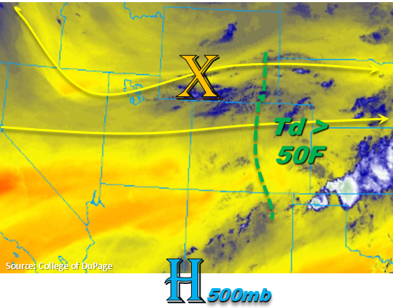
Precipitable Water (PW) values at Grand Junction and Denver are 0.61 inches and 1.01 inches, respectfully. The passing of the cold front overnight returned low-level moisture east of the Continental Divide. Currently, the front is over the Southeast Plains with a surface low near the CO/KS border. This should promote moist, upslope flow this afternoon behind it. This afternoon, high instability and shear will promote some supercells and clusters of strong convection along and just east of I-25. As is common in moist and unstable environments, outflow boundaries from the first storms may help spark more convection. Thunderstorms are also expected form along the Cheyenne Ridge, which if they do, would bring strong storms to the northern counties of Colorado including Weld and Morgan County. With the exception of the Palmer Ridge/Front Range intersect, heavy rainfall should remain east of the higher terrains this afternoon, which is good news for the recent burn scars. Stronger storms will be possible over the Waldo Canyon area, so storms that track into this area will need to be monitored closely.
Threats with the thunderstorms today include heavy rainfall, large hail and strong winds. Storm motion will be to the ESE at 20-25 mph, so widespread flooding is not anticipated. However, multiple storms over one area may be possible, which would increase the 24-hour totals and runoff in the area. Street flooding, field ponding and local stream flooding are all possible. A Moderate flood threat has been issued for the Palmer Ridge, southern Urban Corridor and Southern Front Range. A Low flood threat has been issued for the Front Range, Urban Corridor, Northeast Plains and Southeast Plains.
Today’s Flood Threat Map
For more information on today’s flood threat, see the map below. For Zone-Specific forecasts, scroll below the map.


Zone-Specific Forecasts:
Southeast Mountains, Raton Ridge, Urban Corridor, Northeast Plains, Front Range, Palmer Ridge, Southeast Plains:
The heavy fog over the Northeast Plains should decrease by late morning. However, dew points are expected to remain in the 60Fs over the eastern plains with at least 50F dew points over the Urban Corridor. This will set the stage for some heavy rainfall this afternoon; however, storm motion should be fast enough to prevent widespread flooding. Max 1-hr rain rates up to 1.85 inches/hour are possible further east with 1 inch/hour possible over the Front Range. Localized 24-hour totals just over 2 inches are also possible east of I-25, but dry soils should be able to absorb a lot of moisture and also help prevent widespread flooding. Threats with the stronger thunderstorms today include severe hail, strong winds and local, heavy rainfall. Street and small stream flooding may be possible, especially over low-lying roads. A Moderate and Low flood threat has been issued.
Primetime: 2PM – 4AM
Northern Mountains, Northwest Slope, Central Mountains, Southwest Slope, San Juan Mountains, San Luis Valley, Grand Valley:
Skies should be mostly clear with a few scattered clouds over the higher terrains. Dry air and westerly flow should limit rainfall chances to the higher terrains and along the Continental Divide this afternoon. Rainfall totals are expected to be under 0.05 inches with plenty of virga. Temperatures and smoke will also be on the increase, with lower elevations nearing 100F.
Primetime: 2PM – 7PM