Issue Date: 8/5/2018
Issue Time: 8:05 AM
NO FLOOD THREAT IS FORECAST TODAY.
A group of showers is moving across northern Colorado this morning in response to a weak, passing disturbance. This activity will dissipate/exit the state to the east by lunchtime, just in time for the next round of showers/thunderstorms to begin. This second round will be the main focus for today’s forecast, as it will hold the potential for the strongest storms and heaviest (relatively speaking) rainfall. This second disturbance will kick off storms around lunchtime over the High Country, while upslope flow promotes the additional development of a couple showers/ thunderstorms along/near the Front Range/Urban Corridor between Noon and 2 PM.
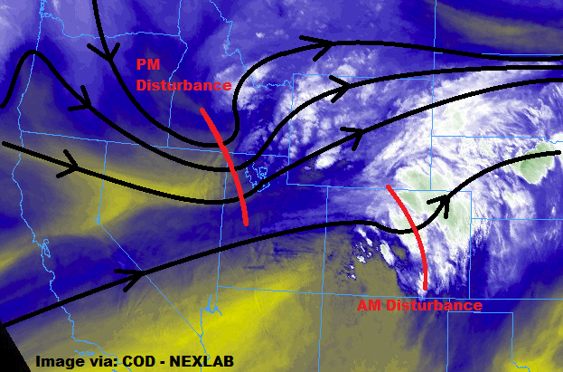
As showers/storms move quickly east of the mountains, they will encounter an environment supportive a couple severe thunderstorms, with the main threats being strong winds (up to 65 mph), hail (up to 1.25 inches in diameter), and brief heavy rainfall. Due to the relatively quick storm motions, the threat of flash flooding is not really a concern. Minor areas of street/field ponding can be expected under the strongest storms, but nothing that warrants the issuance of a flood threat area. Showers/storms will end from west to east as the disturbances passes through; information on timing, along with rain rates, can be found in the zone-specific forecast discussions below.
Today’s Flood Threat Map
For more information on today’s flood threat, see the map below (hover over threat areas for more details). For Zone-Specific forecasts, jump below the map.


Zone-Specific Forecasts
Urban Corridor, Palmer Ridge, Northeast Plains, Southeast Plains, and Raton Ridge:
The area of showers ongoing over portions of the Urban Corridor, Northeast Plains, and Palmer Ridge will continue to move eastward, dissipating/exiting the state around Noon. Today’s main event will kick off around the same time as the next disturbance enters the area, aided by upslope flow. The first showers/thunderstorms will develop over the Urban Corridor, adjacent to the Front Range, between Noon and 2 PM, with storms moving relatively quickly eastward with time. A few of the storms will reach severe thresholds, capable of producing strong winds (up to 65 mph), hail (up to 1.25 inches in diameter), and brief heavy rainfall. Due to the quick storm motions, flash flooding will not be a threat, but minor instances of street/field ponding can be expected under the stronger storms. Maximum rain rates are as follows:
Urban Corridor and Raton Ridge: 0.25-0.5 inches/hour
Palmer Ridge: 0.6-1.0 inches/hour
Northeast Plains and Southeast Plains: 1.0-1.5 inches/hour
Timing: Urban Corridor: Noon – 9 PM. Palmer Ridge: Noon – 10 PM. Northeast Plains: 1 PM – 10 PM. Southeast Plains: 1 PM – 11 PM. Raton Ridge: 1 PM – 10 PM.
Northern Mountains, Northwest Slope, Front Range, Central Mountains, Grand Valley, Southeast Mountains, San Juan Mountains, Southwest Slope, and San Luis Valley:
The area of showers ongoing across portions of the Northern Mountains, Front Range, and Central Mountains will exit the area to the east by 10 AM, which will turn our attention to the second round of showers/storms expected for this afternoon/evening. The next round will kick off around Noon, with showers/storms initially favoring the higher terrain. Showers/storms will track eastward with time, moving over mountains valleys along the way. Coverage and intensity of storms will peak during the afternoon hours, with storms dissipating around 6 PM as the disturbance moves east of the area. A few lingering showers/weak thunderstorms will continue until just after sunset, mainly east of the Continental Divide, ending by 9 PM-10 PM. Generally speaking, rain rates will be in the 0.05-0.15 inch/hour range, with the strongest storms producing rates up to 0.2-0.4 inches/hour.
Timing: Northwest Slope, Grand Valley, and Southwest Slope: Noon – 7 PM. Northern Mountains, Central Mountains, San Juan Mountains, and San Luis Valley: Noon – 8 PM. Front Range and Southeast Mountains: Noon – 10 PM.