Issue Date: 8/4/2018
Issue Time: 8:13 AM
NO FLOOD THREAT IS FORECAST TODAY.
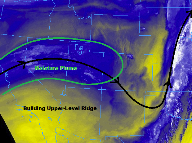
Upper-level high pressure will build across the region today, leading to a drier and warmer day across Colorado. Meanwhile, a plume of mid-level moisture riding the top of the building ridge will stream across the state, providing enough fuel for isolated-to-scattered, high-based showers and thunderstorms. Showers/thunderstorms will kick off over the High Country around lunchtime, with storms moving quickly to the east, moving over the Urban Corridor and western portions of the plains/Palmer Ridge regions by 1-2 PM. Generally speaking, storm coverage will peak during the late afternoon/early evening hours coinciding with peak daytime heat, then diminishing as the sun sets. A few lingering showers will continue into the overnight/early morning hours over the High Country.
Rain rates will be tempered by drier air below cloud bases, causing storms to result in more gusty winds than rain. The bulk of shower/thunderstorm activity is expected over the higher terrain, where orographic effects will aid daytime heating in production of storms. East of the mountains, activity will be more isolated. For information on rain rates and timing, please see the zone-specific forecast discussions below.
Today’s Flood Threat Map
For more information on today’s flood threat, see the map below (hover over threat areas for more details). For Zone-Specific forecasts, jump below the map.


Zone-Specific Forecasts
Urban Corridor, Palmer Ridge, Northeast Plains, Southeast Plains, and Raton Ridge:
Isolated-to-widely scattered, high-based showers/thunderstorms expected to dot the area today, moving quickly from west to east. Dry air below cloud bases will cut back on precipitation efficiency, resulting in maximum rain rates of 0.2-0.4 inches/hour, with general rain rates less than 0.1 inches/hour. Gusty winds will be the main impact today, with gusts up to 25-45 mph from garden-variety showers/thunderstorms, with stronger thunderstorms producing gusts up to 45-65 mph.
Timing: 1 PM – 9 PM, with a few lingering showers/storms until, or just after, Midnight
Northern Mountains, Northwest Slope, Front Range, Central Mountains, Grand Valley, Southeast Mountains, San Juan Mountains, Southwest Slope, and San Luis Valley:
Scattered high-based showers/thunderstorms are expected today, producing more gusty winds than rain. Wind gusts up to 65 mph can be expected from stronger storms, with wind gusts 20-40 mph from garden-variety activity. Dry air below cloud bases will reduce precipitation efficiency, with general rain rates less than 0.1 inches/hour. Maximum rain rates will be 0.2-0.4 inches/hour. Storms will move quickly from west to east, effectively eliminating the flood threat over even the most sensitive burn scars in coordination with the marginal rain rates.
Timing: 11 AM – 9 PM, with a few lingering showers over the higher terrain overnight and into the early morning hours