Issue Date: Friday, August 3rd, 2018
Issue Time: 09:00AM MDT
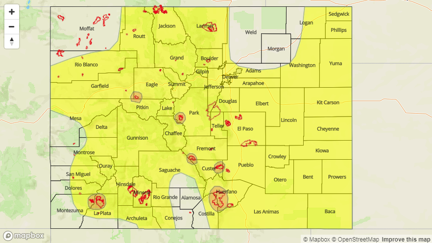
— A MODERATE flood threat has been issued for the following burn scars: 416/Burro, Weston Pass, Spring Creek, Hayden Pass, Junkins
— A LOW flood threat has been issued for portions of each region with the exception of the San Luis Valley
Monsoon moisture is back, which will return the heavy rainfall threat for Friday. The west coast, upper-level trough began its migration eastward today, which shifted the ridge axis with it. This has allowed a plume of subtropical moisture to make its way into the state from west to east. The trough has also released some extra energy, and this vorticity max will help set the stage for more widespread and a bit stronger thunderstorms this afternoon. Currently, the main wave of energy is over western Colorado (marked with orange “X”) and is producing moderate rain and showers over the northwest corner of the state. Without much instability to work with, the lift from this wave is much stronger than the last couple of days where no early morning showers were present. This will reach the eastern portion of the state by early afternoon, just as the upslope flow regime sets up.

Precipitable Water (PW) values at Grand Junction and Denver are 1.16 inches and 0.92 inches, respectfully. This means rainfall intensities should be on the uptick this afternoon and evening. As the vorticity max moves eastward, this will help increase the PW values even more. Storms today over eastern Colorado will be widespread over the mountains and are expected to move into the adjacent plains by early afternoon. Storm coverage over western Colorado, especially the mountains, will increase throughout the morning as well. More than one round of storms are possible as upper-level lift and outflow boundaries will help trigger additional storms in the moist atmosphere. A stronger line of thunderstorms is expected over the far eastern plains, and with higher low-level moisture intensities should also increase. Small hail and strong winds are possible, though limited instability and shear may only produce one or two severe thunderstorms.
With high cloud cover already working its way into eastern Colorado, instability will be limited this afternoon, so not expecting severe thunderstorms over the mountains or immediate adjacent plains. Storm motion should be fairly quick as well, which will limit heavy, local rainfall. Storms may still be able to produce a quick 0.5 inches in 30 minutes though thanks to the abundant low-level moisture. However, without much rain the last couple of days, the soils should be able to absorb a lot of the precipitation and decrease runoff. A Low flood threat has been issued. Threats today include mud flow, debris slides (higher terrains) and street/small stream flash flooding. Burn scars will be especially susceptible today as max 1-hour rain rates will exceed 0.5 inches/hour and multiple storms may track over one area with the more widespread coverage. A Moderate Flood threat has been issued for the following burn scars: 416/Burro, Lake Christine, Hayden Pass, Junkins, Spring Creek and Weston Pass.
Today’s Flood Threat Map
For more information on today’s flood threat, see the map below. For Zone-Specific forecasts, scroll below the map.

Zone-Specific Forecasts:
Northern Mountains, Northwest Slope, Central Mountains, Southwest Slope, San Juan Mountains, San Luis Valley, Grand Valley:
Moderate and light rain showers to kick off today over the northwest corner of the state and San Juan Mountains. High cloud cover over this region and showers should keep high temperatures below normal for the beginning of August. Haze is still be reported in the Central Mountains. Showers and weak thunderstorms are expected throughout the day and a second round is expected this evening. Max 1-hour rain rates up to 0.75 inches/hour are possible with 24-hour totals up to 1 inch over the mountains. A Low flood threat has been issued with a Moderate flood threat for the Lake Christine and 416/Burro burn scars.
Primetime: 11AM – 12AM
Southeast Mountains, Raton Ridge, Urban Corridor, Northeast Plains, Front Range, Palmer Ridge, Southeast Plains:
High clouds to start the day should keep high temperatures relatively cool to the west. More instability will be able to gather over the eastern plains, so 1 or two storms may become severe this evening and produce local, heavy rainfall. Max 1-hour rain rates up to 0.85 inches/hour (west) and 1.3 inches/hour (east) are possible. 24-hour totals just over 1 inch are possible in isolated areas of the mountains. Localized 3-hour totals up to 1.75 inches are possible over the far eastern counties (Yuma, Kit Carson and Cheyenne). A Low flood threat has been issued with a Moderate flood threat for recent burn scars.
Primetime: 11AM – 2AM