Issue Date: Monday, July 30th, 2018
Issue Time: 08:25AM MDT
— Flooding is NOT expected today
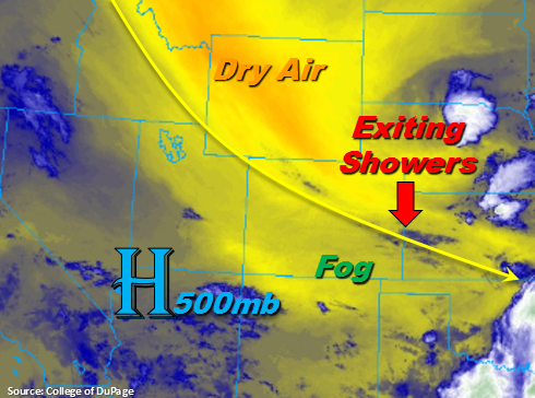
Calm and cool start to the Monday morning after an active day of severe weather across the Northeast Plains on Sunday. Currently, there is a little bit of fog over the Southeast Mountains, but that will begin to breakup this morning as the sun begins to heat the surface. There are also a couple light showers over the far Southeast Plains, which will continue to work their way east by late morning. The mid-level high pressure will continue to sit southwest of Colorado over the Great Basin today, which will provide northerly flow aloft over Colorado. This will pull in dry air (marked in the water vapor imagery below) over the state and bring a break to the heavy rainfall threat this afternoon and evening.
There will be some residual moisture left over the Southern Front Range and Southeast Mountains, so expecting some showers and thunderstorms to pop over the higher terrains this afternoon. Coverage will decrease quite a bit when compared to the last few days and the majority of the rain should remain over the mountains. There is a slight chance for some showers and thunderstorms over the adjacent plains this afternoon, but storms are not expected to become severe or bring a heavy rainfall threat. Over western Colorado, the dry, northerly flow will almost completely nix the chances for rainfall today. The San Juan Mountains might get a few drops of rain, but measurable precipitation is not expected.
Today’s Flood Threat Map
For more information on today’s flood threat, see the map below. For Zone-Specific forecasts, scroll below the map.

Zone-Specific Forecasts:
Front Range, Urban Corridor, Northeast Plains, Palmer Ridge, Southeast Plains, Southeast Mountains, Raton Ridge:
Dry air will move into the state today from Wyoming. Some residual moisture will remain over the southern Front Range and Southeast Mountains, so some isolated rainfall is expected this afternoon over those regions. However, the dry mid-layer will limit rainfall rates. Max 1-hour rain rates up to 0.5 inches are possible though most storms will produce abundant virga and rain rates under 0.25 inches/hour. A couple storms could wander into the adjacent plains, but are not expected to become severe. Flooding is not expected today.
Primetime: 3PM to 8PM
Southwest Slope, San Juan Mountains, San Luis Valley, Grand Valley, Northern Mountains, Northwest Slope, Central Mountains:
The northerly flow aloft will also pull in dry air over western Colorado, which will suppress any chances for measureable rainfall this afternoon. Outside of a few scattered clouds over the Southwest Slope and San Juan Mountains it should be a clear day with temperatures near normal for this time of year. There may be a few drops of rain with the clouds over the San Juans, but the more likely scenario is that they bring some shade and relief to the afternoon heat. Flooding is not expected today.