Issue Date: 7/28/2018
Issue Time: 8:25 AM
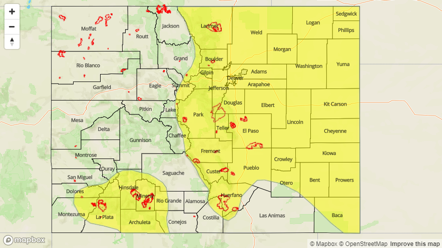
A LOW FLOOD THREAT IS FORECAST FOR PORTIONS OF THE SOUTHWEST SLOPE, SAN JUAN MOUNTAINS, CENTRAL MOUNTAINS, NORTHERN MOUNTAINS, FRONT RANGE, SOUTHEAST MOUNTAINS, URBAN CORRIDOR, PALMER RIDGE, RATON RIDGE, NORTHEAST PLAINS, AND SOUTHEAST PLAINS.
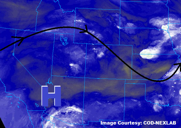
The upper-level high pressure system situated to the southwest of Colorado has moved little since yesterday, leaving large-scale conditions similar to yesterday. This will lead to another period of scattered showers/thunderstorms across the state, with severe weather possible along/east of the Front Range to the CO/KS border. Moisture continues to run above normal, so heavy rainfall remains likely from all stronger thunderstorms. Working against the flood threat, however, is that storms are expected to move a bit quicker than yesterday, with storm motions generally to the east-southeast at 20-30 mph. The main areas to watch for flash flooding will be sensitive burn scars, steep terrain, and poorly drained urban areas, and this is reflected in the flood threat areas outlined in the map below.
Showers/thunderstorms will first develop over the mountains and foothills around lunchtime, spreading east-southeastward with time, exiting the state around midnight or so. East of the mountains, a few storms will reach severe thresholds, producing large hail (1.0-2.5 inches in diameter possible), strong winds (up to 70 mph), and an isolated tornado or two. For more information on rain rates and timing, please see the zone-specific forecast discussions below.
Today’s Flood Threat Map
For more information on today’s flood threat, see the map below (hover over threat areas for more details). For Zone-Specific forecasts, jump below the map.

Zone-Specific Forecasts
Front Range, Southeast Mountains, Urban Corridor, Palmer Ridge, Northeast Plains, Southeast Plains, and Raton Ridge:
Scattered showers and thunderstorms expected again today/tonight, with a few reaching severe thresholds, especially east of I-25 and north of Highway 50. Heavy rain, strong winds, large hail, and a couple isolated tornadoes are possible. Storm motions will be quick enough to mitigate most of the flood risk, but urban areas, vulnerable terrain, sensitive burn scars, and areas that have received heavy rain over the last few days should be monitored. Maximum rain rates are as follows:
Front Range and Southeast Mountains: 0.6-1.0 inches/hour
Urban Corridor and Palmer Ridge: 1.0-1.2 inches/hour
Northeast Plains and Southeast Plains: 1.5-2.5 inches/hour
Raton Ridge: 0.3-0.6 inches/hour
Timing: 11 AM – 11 PM for the Front Range and Southeast Mountains, Noon – Midnight elsewhere
Northern Mountains, Northwest Slope, Central Mountains, Grand Valley, San Juan Mountains, Southwest Slope, and San Luis Valley:
Another day of scattered showers/thunderstorms are expected, beginning around lunchtime, peaking in coverage/intensity during the late afternoon/early evening, and diminishing quickly after sunset. The main impacts will be gusty winds and periods of light-to-moderate rainfall, as drier air below cloud bases zaps the atmosphere’s ability to efficiently produce heavy precipitation. The best low-level moisture remains over the Southwest Slope and San Juan Mountains, thus the low flood threat continues for those regions. Maximum rain rates are as follows:
Northwest Slope, Grand Valley, and San Luis Valley: 0.2-0.5 inches/hour
Northern Mountains: 0.4-0.7 inches/hour
Central Mountains: 0.5-0.8 inches/hour
Southwest Slope and San Juan Mountains: 0.6-1.0 inches/hour
Timing: 11 AM – 9 PM, with a few lingering showers/weak thunderstorms until midnight