Issue Date: 7/27/2018
Issue Time: 9:52 AM
A MODERATE FLOOD THREAT IS FORECAST FOR PORTIONS OF THE SOUTHWEST SLOPE AND SAN JUAN MOUNTAINS.
A LOW FLOOD THREAT IS FORECAST FOR PORTIONS OF THE SOUTHWEST SLOPE, SAN JUAN MOUNTAINS, CENTRAL MOUNTAINS, NORTHERN MOUNTAINS, FRONT RANGE, SOUTHEAST MOUNTAINS, URBAN CORRIDOR, PALMER RIDGE, RATON RIDGE, NORTHEAST PLAINS, AND SOUTHEAST PLAINS.
The upper-level high still sits to the southwest of Colorado, continuing to send a stream of mid-level moisture across our area. This will set the stage for another period of scattered showers/thunderstorms across the state. Precipitable water values continue to run above seasonal average, so heavy rainfall will be a threat once again. The strongest storms of the day will occur east of the Divide, where conditions are favorable for the development of a few severe storms today, especially east of I-25. Large hail, damaging winds, and periods of heavy rainfall will be the main threats, with an isolated tornado or two also possible. The good news on the heavy rainfall threat is that storm motions will be quick enough to help mitigate the flood threat, but it will not eliminate it completely. A broad low flood threat is once again in place.
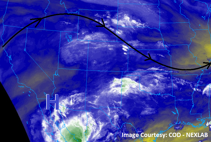
To the west of the Divide, an uptick in showers/thunderstorms as compared to yesterday is expected. Just as for storms east of the Divide, storm motions will help mitigate the flood threat, but not eliminate it completely. In fact, a moderate flood threat is in place for burn scars of the Southwest Slope and San Juan Mountains regions, due to the combination of antecedent soil moisture, sensitivity of burn scars, and the threat of additional heavy rainfall. For additional information on rain rates and timing, please see the zone-specific forecast discussions below.
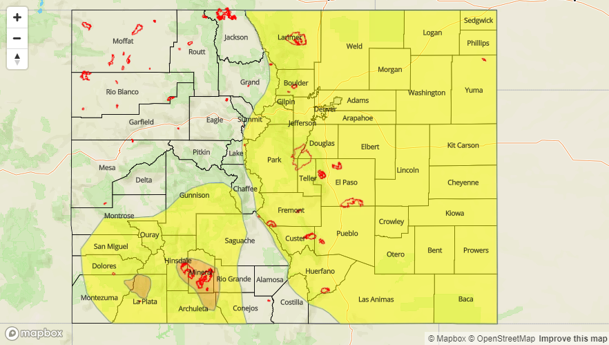
Today’s Flood Threat Map
For more information on today’s flood threat, see the map below (hover over threat areas for more details). For Zone-Specific forecasts, jump below the map.

Zone-Specific Forecasts
Front Range, Southeast Mountains, Urban Corridor, Palmer Ridge, Northeast Plains, Southeast Plains, and Raton Ridge:
Scattered showers/thunderstorms expected today/tonight, capable of heavy rainfall. A few storms will become severe, producing large hail, damaging winds, and an isolated tornado or two. Relatively quick storm motions will limit the flood threat, but not eliminate it completely. Maximum rain rates are as follows:
Front Range and Southeast Mountains: 0.6-1.2 inches/hour
Urban Corridor, Raton Ridge, and Palmer Ridge: 1.2-1.8 inches/hour
Northeast Plains and Southeast Plains: 2.0-2.5 inches/hour
Timing: Noon – 11 PM for the Front Range and Southeast Mountains, 1 PM – 1 AM for the Urban Corridor, Palmer Ridge, Raton Ridge, Northeast Plains, and Southeast Plains
Northern Mountains, Northwest Slope, Central Mountains, Grand Valley, San Juan Mountains, Southwest Slope, and San Luis Valley:
Scattered showers and thunderstorms are on tap today/tonight. Most will be garden-variety, but enough moisture exists for a few storms to produce periods of moderate-to-heavy rainfall, especially over southern mountains. Maximum rain rates are as follows:
Southwest Slope, San Juan Mountains, and Central Mountains: 0.8-1.2 inches/hour
Northwest Slope and Grand Valley: 0.25-0.5 inches/hour
Northern Mountains: 0.6-1.0 inches/hour
San Luis Valley: 0.5-1.0 inches/hour
Timing: 11 AM – 9 PM, with a few lingering showers/weak thunderstorms until midnight.