Issue Date: 7/26/2018
Issue Time: 8:42 AM
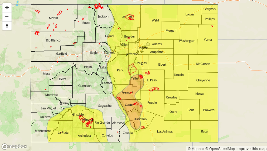
A MODERATE FLOOD THREAT IS FORECAST FOR PORTIONS OF THE SOUTHEAST MOUNTAINS, FRONT RANGE, URBAN CORRIDOR, RATON RIDGE, AND SOUTHEAST PLAINS REGIONS.
A LOW FLOOD THREAT IS FORECAST FOR PORTIONS OF THE SOUTHWEST SLOPE, SAN JUAN MOUNTAINS, CENTRAL MOUNTAINS, NORTHERN MOUNTAINS, FRONT RANGE, SOUTHEAST MOUNTAINS, RATON RIDGE, PALMER RIDGE, URBAN CORRIDOR, NORTHEAST PLAINS, AND SOUTHEAST PLAINS.
The upper-level high that has kept moisture streaming across Colorado the past few days isn’t budging much today. This means another day/night of scattered showers and thunderstorms across the state. Over the High Country west of the Continental Divide, precipitable water values will be less than yesterday as drier air works in from the west/northwest, and a downtick in storm coverage is expected for those areas. Even so, there will be enough moisture available for moderate rainfall rates, especially over southern mountains. This moisture, combined with antecedent soil moisture and burn scar concerns, are the culprits behind the low flood threat over the Southwest Slope and San Juan Mountains.
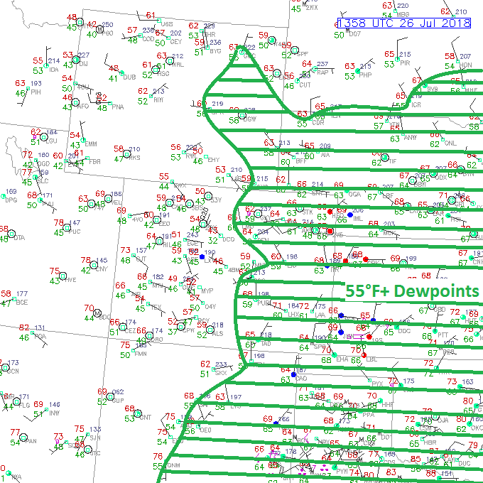
East of the Continental Divide, low-level easterly flow will reinforce moisture values, keeping precipitable water values near/above 1 inch across much of the area, but especially east of I-25. This will provide the fuel for scattered showers and thunderstorms capable of heavy rainfall. Storm motions will be a bit faster today, so that will mitigate the flood threat somewhat, reducing storm residence time over one location. With that said, however, the last few days of heavy rain will exacerbate runoff in areas that have received it, especially in areas of steep and vulnerable terrain. Thus, the issuance of the Moderate Flood Threat for portions of of the Southeast Mountains, Front Range, Urban Corridor, Raton Ridge, and Southeast Plains regions. Eastern plains areas that have received excessive rainfall will also deserve a close eye inside the low flood threat zone. For more information on timing and rain rates, please see the zone-specific forecast discussions below.
Today’s Flood Threat Map
For more information on today’s flood threat, see the map below (hover over threat areas for more details). For Zone-Specific forecasts, jump below the map.

Zone-Specific Forecasts
Front Range, Southeast Mountains, Urban Corridor, Palmer Ridge, Northeast Plains, Southeast Plains, and Raton Ridge:
Another unsettled period of scattered showers/thunderstorms are expected, capable of heavy rainfall. Storm motions will be quicker than previous days, so the flooding threat will be mitigated somewhat. As mentioned above, areas that have received heavy rainfall over the last few days are at the highest relative risk of flash flooding issues. The wind/instability profile will be conducive to a few strong-to-severe thunderstorms, capable of producing large hail up to 1.75 inches in diameter, strong winds (gusts up to 70 mph), and an isolated tornado or two. Maximum rain rates are as follows:
Front Range and Southeast Mountains: 1.0-1.2 inches/hour
Urban Corridor: 1.0-1.4 inches/hour
Northeast Plains, Southeast Plains, Palmer Ridge, and Raton Ridge: 1.75-2.5 inches/hour
Timing: Noon – 9 PM over the Front Range and Southeast Mountains, with a lingering shower/thunderstorm or two over the Southeast Mountains until 11 PM. 1 PM – 10 PM for the Urban Corridor and Palmer Ridge, and 1 PM – Midnight for the Northeast Plains, Southeast Plains, and Raton Ridge. A few showers/thunderstorms will linger near the CO/KS border into the early morning hours.
Northern Mountains, Northwest Slope, Central Mountains, Grand Valley, San Juan Mountains, Southwest Slope, and San Luis Valley:
Scattered showers and thunderstorms are expected again today/tonight, though a slight downtick in coverage and intensity is expected compared to previous days. As usual, activity will get its start around 11 AM – Noon, increase in coverage through the late afternoon/early evening, and diminish as sunset rolls around. Storm motions will be quicker than previous days, to the south-southeast at 15-25 mph, so the flood threat will be mitigated somewhat. Maximum rain rates are as follows:
Northwest Slope and Grand Valley: 0.1-0.3 inches/hour
Northern Mountains and Central Mountains: 0.4-0.8 inches/hour
Southwest Slope, San Juan Mountains, and San Luis Valley: 0.5-0.9 inches/hour
Timing: 11 AM – 9 PM