Issue Date: Tuesday, July 24th, 2018
Issue Time: 10:20 AM MDT
Summary:
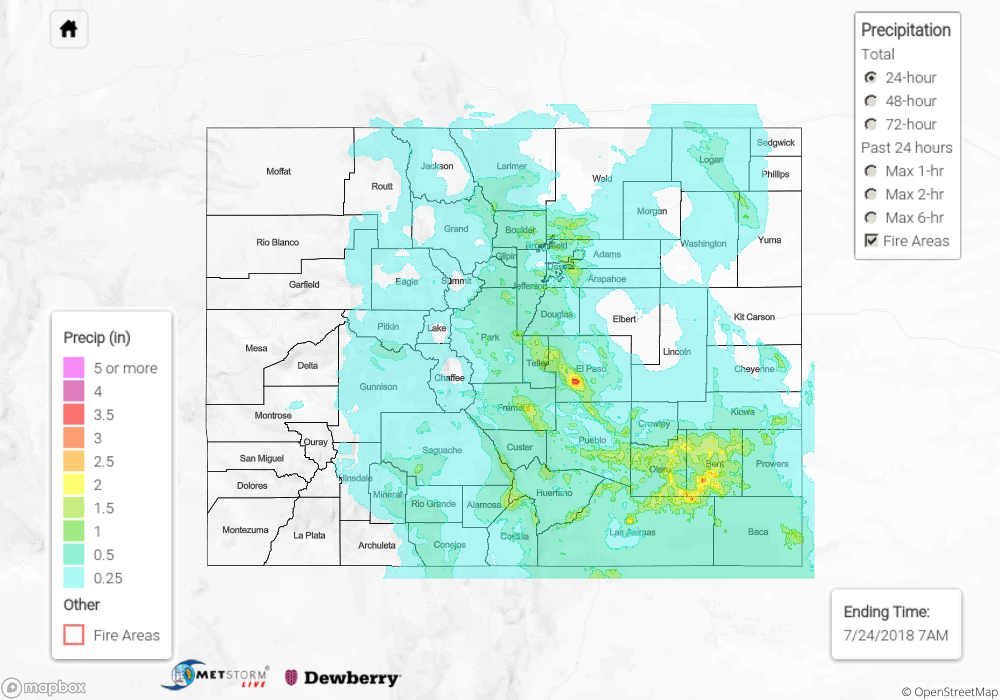
Wild weather day across eastern Colorado yesterday. There was a little bit of everything – heavy rain, flash flooding, debris flows and finally, one confirmed tornado in Park County. High precipitable water values were streaming in from the Gulf of Mexico over Colorado. After the passage of a cold front, the low-levels were primed for widespread, heavy rainfall yesterday. Storms began to fire over the Front Range and Southeast Mountains just after 12PM. While storm motion was fairly quick to the southeast, back building and multiple rounds of pulse-like storms aided by upper-level support (shortwaves) were able to trigger flooding in an hour or less. There was a debris flow reported on Highway 24 in El Paso County that shut the highway down for a bit. This same storm produced so much rainfall that it triggered the sirens in Manitou Springs. These sirens evacuated low-lying areas of the town. There was also a debris flow reported near the Royal Gorge and another near Bailey on 285.
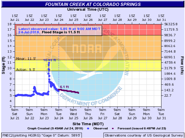
Flash flooding was widespread over the Southeast Mountains and Front Range/Urban Corridor especially in low-lying intersections. A flash flood warning was issued for the La Veta area as a storm that tracked over the Spring Creek burn scar produced flash flooding along Highway 160. Not surprisingly, Fountain Creek had minor flooding at Green Mountains Falls. Below is the gage at Colorado Springs, where it reached just below minor flooding. It doesn’t help that the storms moved into the Urban Corridors around rush hour causing many cars to stall in the high water. Please don’t drive through standing water. It can take as little as 6 inches to lose control of your vehicles.
As far as observations yesterday. A CoCoRaHS in El Paso County (north of Fountain) recorded 4.12 inches for the 24-hour period with another nearby station recording 3.88 inches! A trained spotter 2 miles NW of Colorado Springs recorded 1.8 inches over a 20 minute period. Further north over Denver, an ALERT gage recorded 2.76 inches in an hour over Aurora (2.87 for the 24-hour period). While a QC will be done on this gage in the off-season (hail contamination), that would be the second highest recorded 1-hour QPE (quantitative precipitation estimate) since Dewberry started collecting data in 2015. The storms formed a mesoscale convective system (MCS) over the far eastern plains that also brought flooding to Lamar and La Junta. There was over a foot of water flowing across Main Street in downtown Lamar around 10PM. Lastly, the Ute Creek SNOTEL site north of Fort Garland had the highest SNOTEL rainfall value for the day – 1.8 inches with 1 inch falling between 2 and 3PM.
To see how much precipitation fell in your area, scroll down to the State Precipitation Map below.
Click Here For Map Overview