Issue Date: Tuesday, July 24th, 2018
Issue Time: 09:40AM MDT
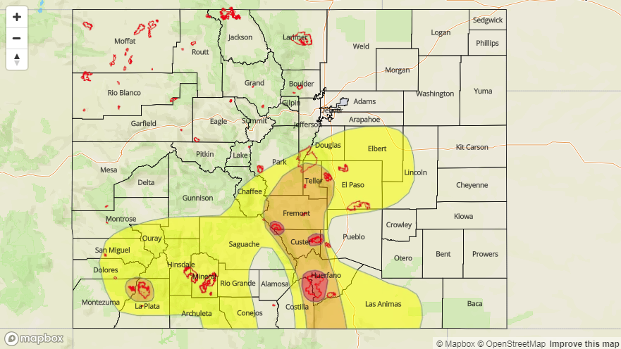
— A HIGH flood threat has been issued for the Spring, Junkins and Hayden Pass burn areas
— A MODERATE flood threat has been issued for the 416/Burro Scar, Southeast Mountains, and portions of the Front Range, Urban Corridor and Raton Ridge
— A LOW flood threat has been issued for portions of the the Front Range, Urban Corridor, Palmer Ridge, Raton Ridge and Southeast Plains
Low-level moisture will hang on again today, with the heavy rainfall threat shifting a bit further south. The threat for flooding today will be greatest over the southern high terrains and the recent burn scars in this vicinity. Currently, there is some heavy fog over the Urban Corridor and some showers over the Grand Valley and Central Mountains as marked in the visible satellite imagery below. The fog will begin to breakup this morning as the sun begins to heat up the surface and dry out the lower atmosphere.
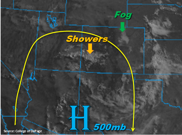
The closed, but broad, upper-level high will continue to spin over New Mexico and Arizona throughout the day with slight movement to the west. This will pull in more subtropical moisture over the southwest corner of the state, as shown by the current showers. Not expecting this moisture to make it too far north, but showers should increase over the Central Mountains this afternoon. Over eastern Colorado, the slight movement west will produce more of a northerly component to the upper-level flow. This will begin to dry out the atmosphere over the northern half of the state; thus, confining the main threat to the Palmer Divide, Southeast Mountains and Raton Ridge. Some showers may move into the Northeast Plains that develop over the Cheyenne Ridge, but unless the storms can reach south (Palmer Ridge), they will produce more gusty winds than heavy rainfall.
Upslope flow will initiate showers and thunderstorms a couple hours later than yesterday. Movement of storms will again be to the SE, but at a bit faster pace today (20-25 knots). However, if yesterday proved anything, it’s that this deep moisture in the atmosphere can easily produce heavy rainfall and flash flooding in a 30 minute span. This is especially true if a storm tracks over a burn scar. The storms won’t have as much upper-level support this afternoon, so heavy, overnight thunderstorms are not forecast over the eastern plains. Soils over the Southeast Mountains are likely saturated from yesterday, so expecting an increase in runoff this afternoon. Thus, a Moderate flood threat has been issued for this area. Threats include mud flows, debris slides and flash flooding over the steeper terrains. A High flood threat has been issued for the Hayden Pass, Junkins and Spring burn scars due to high confidence rain rates in the area will exceed 0.5 inches/hour, which over saturates soils, will cause flooding problems. To the west, a Low flood threat has been issued for the San Juan Mountains. Max 1-hour rain rates up to 1 inch are possible with gusty winds and abundant lightning. A Moderate flood threat has also been issued for the 416 and Burro burn scars since there is high confidence rain rates in the area will exceed 0.5 inches/hour. Please scroll down below for your zone specific forecasts.
Today’s Flood Threat Map
For more information on today’s flood threat, see the map below. For Zone-Specific forecasts, scroll below the map.

Zone-Specific Forecasts:
Front Range, Urban Corridor, Northeast Plains, Northern Mountains, Northwest Slope:
Drier air will begin working its way into the atmosphere this morning and afternoon as shown at the 600mb level in Denver’s sounding this morning. This should limit widespread shower and thunderstorm activity over the Front Range and Urban Corridor, minus the southern portions of these areas. Some thunderstorms may move into the state that form over the Cheyenne Ridge, but with dew points in the 50Fs and fast storm motion, gusty winds and large hail are more of a threat than local, heavy rainfall. Max 1-hour rain rates up to 0.7 inches (north) and 1.0 inches (south) are possible. Over the northwest corner of the state, very dry air will work its way into the area, which will only allow for some cloud cover over the higher terrains this afternoon. Flooding is not expected today.
Primetime: 3PM to 10PM
Palmer Ridge, Southeast Plains, Southeast Mountains, Raton Ridge:
A very moist atmosphere will support heavy rainfall again this afternoon. With saturated soils from yesterday’s multiple rounds of thunderstorms, expecting increased runoff this afternoon. Max 1-hour rain rates up to 1.1 inches/hour are possible, which over saturated soils, could trigger mud flows, debris slides and local stream flooding this afternoon. A Moderate Flood threat has been issued. There is high confidence storms in the area will produce rain rates greater than 0.5 inches/hour, so all recent burn scars are under a High flood threat again today. Some storms may wander into the adjacent plains this afternoon, but only storms located near the Palmer Ridge and Raton Ridge have the potential for flooding. Over this area, max 1-hour rain rates up 1.3 inches/hour are possible. A few stray thunderstorms may make their way into the Southeast Plains later this evening, but they are not expected to cause flooding.
Primetime: 2PM to 10PM
Southwest Slope, San Juan Mountains, San Luis Valley, Grand Valley, Central Mountains
Low-level moisture won’t be quite as high over western Colorado, but the shift in the upper-level high will pull some subtropical moisture back into the area. With westerly flow aloft, the majority of the storms this afternoon will be confined to the higher terrains. Max 1-hour rain rates up to 1 inch/hour are possible over the San Juan Mountains. A Low flood threat has been issued with a Moderate flood threat over the 416 and Burro burn scars due to storms in the area having rain rates that will exceed 0.5 inches/hour. Threats include mud flows, debris slides and local stream flooding. Over the Central Mountains, max 1-hour rain rates decrease to 0.25 inches/hour. Thunderstorms here and over the Grand Valley will produce gusty winds and dangerous lightning.
Primetime: 1PM to 8PM