Issue Date: Monday, July 23rd, 2018
Issue Time: 09:10AM MDT
— A HIGH flood threat has been issued for the Spring Creek, Junkins and Hayden Pass burn areas
— A HIGH flood threat has been issued for portions of the Front Range, Urban Corridor, Northeast Plains, Palmer Ridge and Southeast Plains
— A MODERATE/LOW flood threat has been issued for the Front Range, Urban Corridor, Northeast Plains, Palmer Ridge, Raton Ridge and Southeast Plains
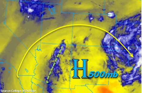
The closed, upper-level high pressure continues to spin over New Mexico again today, which will bring westerly flow aloft into the state. This flow will continue to hold high moisture in-place to the east and rotate upper-level disturbances from Arizona into the state. The disturbances can been seen in the water vapor imagery below (green) and will help enhance lift later this afternoon. Upslope flow is expected to initiate numerous showers and thunderstorms over the higher terrains early this afternoon as low-level winds become perpendicular to the higher terrains. Best initial coverage of storms today will be along the Front Range and Southeast Mountains. Low-level moisture over the San Juan and Central Mountains decreases throughout the day, so storms will produce more gusty winds and dry lightning this afternoon and evening.
Ample moisture remains east of the Continental Divide, which brings the threat of heavy rainfall again this afternoon. Dew points are expected to remain in the 50sF (west) to 60sF range (east), so rainfall efficiencies will intensify when compared to yesterday. Precipitable Water at Denver this morning was 1.21 inches, which is in the 90th percentile for this date and 0.1 inches below the daily max. Numerous outflow boundaries from yesterday’s convection will also help trigger thunderstorms over the eastern plains in the high moisture environment. As storms move into the adjacent plains off the mountains, their movement will be to the southeast at about 20 knots. This should help limit the threat to an hour, although the potential mesoscale convective system (MCS) will still produce rain rates capable of heavy rainfall and flooding of low-lying areas, roads and local streams. There will likely be a second round of showers this evening for the adjacent plains as outflow boundaries will continue to kick off showers and thunderstorms in the moist environment. The thunderstorms will eventually turn into showers as instability decreases, but will likely linger over the Southeast Plains and Palmer Ridge into tomorrow morning. The flood threat will also decrease overnight.
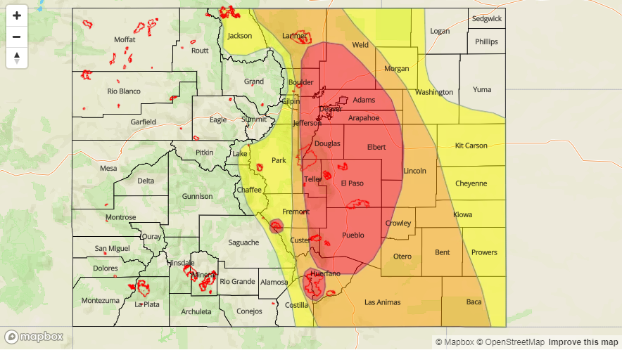
Recent burn scars over the Southeast Mountains will need to be monitored closely today. Rain rates up to 1 inch/hour are possible, which would cause flash flooding, mud flows and debris slides. A High Flood threat has been issued for these scars and portions of the Urban Corridor, Palmer Ridge and Southeast Plains. Threats include flash flooding of roads, local streams and low-lying areas. Over the higher terrains threats include local stream flooding, mud flows and debris slides.
Today’s Flood Threat Map
For more information on today’s flood threat, see the map below. For Zone-Specific forecasts, scroll below the map.

Zone-Specific Forecasts:
Front Range, Urban Corridor, Palmer Ridge, Southeast Plains, Northeast Plains, Southeast Mountains, Raton Ridge:
Very moist low-level will support heavy rainfall this afternoon. Showers and thunderstorms should kick off just after noon over the higher terrains. Over the higher terrains max 1-hour rain rates up to 1.25 inches are possible, which could trigger mud flows, debris slides and local stream flooding. Rain rates increase over the adjacent plains with 1-hour rain rates around 1.75 inches/hour. Localized 1-hour rain rates over 2 inches/hour are not out of the question in areas of the highest low-level moisture. A High flood threat has been issued for portions of these regions with the largest threat over the Urban Corridor, Palmer Ridge and Southeast Plains. A High flood threat has also been issued for all recent burn scars over the Southeast Mountains as storms could trigger debris slides and local stream flooding that track over these areas. Thunderstorms and showers will continue to rumble into the night, but the flood threat should decrease after midnight.
Primetime: 12PM to 7AM
Southwest Slope, San Juan Mountains, San Luis Valley, Northern Mountains, Grand Valley, Central Mountains, Northwest Slope:
Low-level moisture won’t be quite as high over western Colorado. Max 1-hour rain rates up to 0.4 inches/hour are possible over the higher terrain this afternoon. Upslope flow will be the main driver of thunderstorm development today, and with westerly winds, the rainfall should remain over the mountains with the greatest cover near the Continental Divide.
Primetime: 1PM to 8PM