Issue Date: Friday, July 20th, 2018
Issue Time: 08:30AM MDT
— A LOW flood threat has been issued for the 416 and Burro burn areas
The shift in the weather pattern begins today. The upper level high will start to move into NM and the Texas panhandle as seen in the water vapor imagery below. This will shift the subtropical moisture axis on its west side into western Colorado and start pulling higher low and mid-level moisture. The position of the high will limit how far north the larger Precipitable Water (PW) values will get, but there will be an uptick in shower activity across all the western higher terrain this afternoon. The storms to the north will likely produce gusty winds and plentiful virga as surface moisture is not as abundant as further south. With low level moisture returning to the San Juan Mountains, the 416 and Burro burn scars will need to be monitored closely for storms that track over those areas this afternoon. The max 1-hour rain rates are expected to exceed 0.25 inches/hour over San Juans, so a Low flood threat has been issued for the two burn scars.
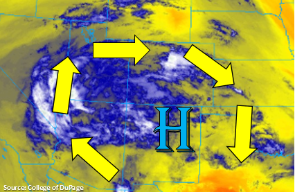
Similar to the west, over eastern Colorado, the higher PW values will be located over the southern half of the state and far eastern plains. This means increased shower activity over the Southeast Mountains, Raton Ridge and Southeast Plains this afternoon and evening. There will be a fairly large spread between the dew points and temperature over southern mountains and adjacent plains, so gusty winds are expected with the storms that form this afternoon. Better moisture is able to hold on over the Southeast Plains, so as the storms make their way east, they will increase their rain rate efficiencies. However, max 1-hour rain rates will remain below 1 inch, so flooding is not expected.
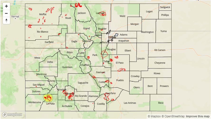
Today’s Flood Threat Map
For more information on today’s flood threat, see the map below. For Zone-Specific forecasts, scroll below the map.

Zone-Specific Forecasts:
Southwest Slope, San Juan Mountains, San Luis Valley, Northern Mountains, Grand Valley, Central Mountains, Northwest Slope:
Subtropical moisture begins to return to western CO this afternoon. Increased shower and thunderstorm activity is expected for the southern half of these regions. To the north, expecting more cloud cover and virga. There is a Low threat for the 416 and Burro burn scars as storms in the area are expected to have max 1-hour rain rates up to 0.4 inches/hour. If one of these storms tracks over a recent burn scar, this could trigger mud flows and debris slides. Max 1-hour rain rates will be closer to 0.2 inches/hour over the Central Mountains. Thunderstorms will transition into lighter showers after sundown, and all shower activity will end by 10PM.
Primetime: 1:30PM to 8PM
Front Range, Urban Corridor, Palmer Ridge, Southeast Plains, Northeast Plains, Southeast Mountains, Raton Ridge:
Similar to western Colorado, the southern high terrains will have the bulk of the afternoon thunderstorm activity. With a higher spread between dew point and temperature, rain rates will be under 0.25 inches/hour. As the storms track east, they will encounter better moisture over the eastern plains. The best chances for thunderstorms this afternoon will be over the Southeast Plains, though a stray thunderstorm could form over the Northeast Plains. Max 1-hour rain rates up to 0.8 inches are possible with gusty winds and dangerous cloud-to-ground lightning.
Primetime: 2PM to 10:30PM