Issue Date: 7/18/2018
Issue Time: 8:05 AM
NO FLOOD THREAT IS FORECAST TODAY.
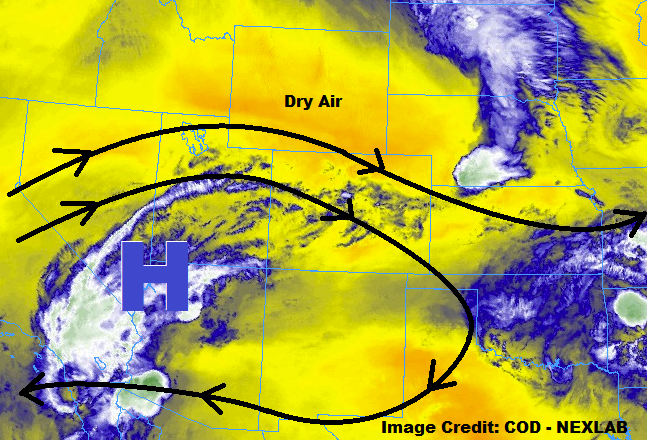
Upper-level high pressure will become centered over southern UT/northern AZ later today, ushering in drier air from the northwest across the northern half of Colorado. Across southern Colorado, moisture trapped under the ridge will provide the fuel for a few weak, isolated thunderstorms, mainly over the higher terrain of the Southwest Slope, San Juan Mountains, Grand Valley, Southeast Mountains, and southern portions of the Central Mountains and Front Range regions. The main story today, though, will be the increase in high temperatures and sunshine compared to previous days.
One or two isolated storms are also possible over the lower elevations of eastern Colorado, south of I-70, near the higher terrain. Over the Southeast Plains, near the CO/KS border, an isolated strong-to-marginally severe thunderstorm cannot be ruled out. In general, though, the day will be marked by temperatures 5-10 degrees warmer than yesterday with plenty of sunshine.
Today’s Flood Threat Map
For more information on today’s flood threat, see the map below (hover over threat areas for more details). For Zone-Specific forecasts, jump below the map.


Zone-Specific Forecasts
Urban Corridor, Palmer Ridge, Northeast Plains, Southeast Plains, and Raton Ridge:
Mostly sunny skies and dry conditions will be the name of the weather game for the vast majority of the area as drier air and high pressure moves in. A couple isolated storms during the afternoon/evening hours are possible near the higher terrain south of I-70, as well as along the CO/KS border. Brief periods of moderate rainfall will attend stronger storms, but flooding issues are not expected. Maximum rain rates will be 0.25-0.5 inches/hour.
Timing: 4 PM – 10 PM
Northern Mountains, Northwest Slope, Front Range, Central Mountains, Grand Valley, San Juan Mountains, Southwest Slope, Southeast Mountains, and San Luis Valley:
Much of the area will remain dry today, with high temperatures warming 5-10 degrees or so over yesterday’s reading. A few isolated showers/weak thunderstorms are expected over the higher terrain south of I-70. Brief periods of moderate rainfall will attend thunderstorms, but owing to their widely isolated nature, no flood threat will be issued. It is recommended to keep an eye on the 416 Fire, Burro Fire, and West Fork complex scars due to the amount of rainfall they have received over the past few days, just in case. Maximum rain rates will be 0.25-0.5 inches/hour, with rain rates generally below 0.2 inches/hour.
Timing: 1 PM – 9 PM, with a couple lingering showers over southern mountains until 11 PM – Midnight