Issue Date: 7/8/2018
Issue Time: 7:15 AM
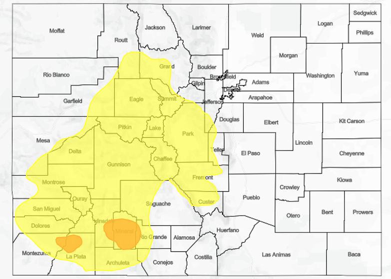
A MODERATE FLOOD THREAT IS FORECAST FOR PORTIONS OF THE SOUTHWEST SLOPE AND SAN JUAN MOUNTAINS TODAY, NAMELY THE 416 FIRE, BURRO FIRE, AND WEST FORK COMPLEX BURN AREAS.
A LOW FLOOD THREAT IS FORECAST FOR PORTIONS OF THE SOUTHWEST SLOPE, SAN JUAN MOUNTAINS, CENTRAL MOUNTAINS, GRAND VALLEY, NORTHWEST SLOPE, NORTHERN MOUNTAINS, FRONT RANGE, AND SOUTHEAST MOUNTAINS, MAINLY DUE TO RECENT/ONGOING FIRE BURNS.
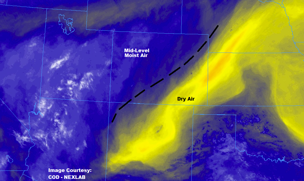
Today will be nearly a repeat of yesterday as the large-scale conditions change little and moisture remains trapped underneath the upper-level ridge. The High Country will once again see scattered showers/thunderstorms focused over the higher terrain, drifting over adjacent lower valleys with time. Most storms will be along and west of the Continental Divide, with more isolated coverage expected over the mountains east of the Continental Divide. The focus areas for the flood threat today, as yesterday, will be the numerous fire burn areas across the High Country, with the highest threat over the sensitive 416 Fire and Burro Fire burn areas.
East of the mountains, the main weather story will be another day of hot temperatures, with highs similar to those experienced Saturday. A couple late-afternoon/evening storms will be possible over the Urban Corridor, Palmer Ridge, and western portions of the Northeast Plains. This activity will be driven by the peak of daytime heating, and will be isolated in coverage. Gusty winds, lightning, and light-to-moderate rainfall will be the main threats.
NOTE: Due to technical difficulties beyond our control, the flood threat map today will be a static image and not zoom-able as usual. We apologize for any inconvenience this may cause, and we will do everything we can to have this fixed ASAP.
Today’s Flood Threat Map
For more information on today’s flood threat, see the map below (hover over threat areas for more details). For Zone-Specific forecasts, jump below the map.

Zone-Specific Forecasts
Urban Corridor, Palmer Ridge, Northeast Plains, Southeast Plains, and Raton Ridge:
The heat will be the main weather story for most, with high temperatures similar to yesterday’s readings. Another weak surface boundary will take shape on a line roughly from Castle Rock to Briggsdale, which will provide enough convergence, coinciding with peak heating, for a few isolated, high-based storms over the Urban Corridor and western portions of the Northeast Plains and Palmer Ridge. Gusty winds, lightning, and light-to-moderate rainfall will be the main impacts. Any storm activity will diminish as the sun fades, ending around 9 PM. Maximum rain rates will be 0.4-0.6 inches/hour.
Timing: 2 PM – 9 PM
Northern Mountains, Northwest Slope, Front Range, Central Mountains, Grand Valley, San Juan Mountains, Southwest Slope, Southeast Mountains, and San Luis Valley:
Another day of scattered showers and thunderstorms are on tap for the higher terrain along and west of the Continental Divide, with more isolated coverage for the higher terrain east of the Divide. Storms will drift in a generally southwestward direction over adjacent lower valleys. Precipitable water values will remain above normal, providing showers/storms with enough moisture for efficient rainfall production. Much of that moisture is confined to the mid-levels, however, so evaporation below cloud bases will reduce the actual rain rates at the surface. All in all, it is another day where burn scars need to be monitored. Maximum rain rates are as follows:
Northern Mountains, Northwest Slope, Grand Valley, and Central Mountains: 0.5-0.7 inches/hour
Front Range and Southeast Mountains: 0.4-0.6 inches/hour
Southwest Slope and San Juan Mountains: 0.5-0.9 inches/hour
San Luis Valley: 0.15-0.35 inches/hour
Timing: Noon – 9 PM, with a couple lingering storms into the early morning hours