Issue Date: 7/7/2018
Issue Time: 8:15 AM
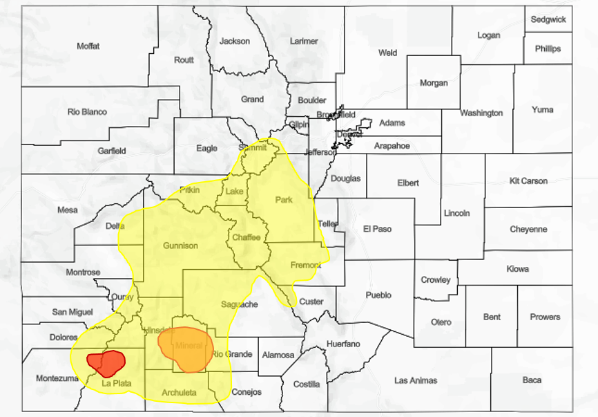
A HIGH FLOOD THREAT IS FORECAST TODAY FOR PORTIONS OF THE SOUTHWEST SLOPE AND SAN JUAN MOUNTAINS, NAMELY THE 416 FIRE AND BURRO FIRE BURN AREAS.
A MODERATE FLOOD THREAT IS FORECAST FOR PORTIONS OF THE SAN JUAN MOUNTAINS, NAMELY THE WEST FORK COMPLEX BURN AREAS.
A LOW FLOOD THREAT IS FORECAST FOR PORTIONS OF THE SOUTHWEST SLOPE, SAN JUAN MOUNTAINS, CENTRAL MOUNTAINS, GRAND VALLEY, FRONT RANGE, AND SOUTHEAST MOUNTAINS, MAINLY DUE TO RECENT/ONGOING FIRE BURNS INCLUDING THE SPRING, CHATEAU, ADOBE, SUGARLOAF, AND WESTON PASS FIRES.
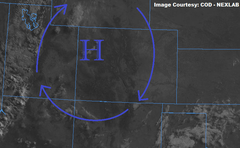
The Rocky Mountains provide an incredible backdrop for pictures and events, but today they will also be the reason behind a dichotomy of weather regimes across the state. Strong high pressure aloft has settled over the region, with the 500 mb center over northwest Colorado. This high pressure has started today with abundant sunshine across the state, as seen in the visible image below. As the day warms up underneath the sunshine, orographic lift will take shape alongside the heat, working on residual moisture trapped underneath the ridge to force scattered showers/thunderstorms over the mountains. The bulk of precipitation will occur over the higher terrain of the Southwest Slope and San Juan Mountains due to the best moisture residing there, and that’s where we find the High/Moderate flood threats for today/tonight. The 416 Fire and Burro Fire are under the High Threat, due to it taking as little as 0.2-0.3 inches/hour rainfall to cause flash flooding, debris slides, and mud flows in, and immediately downstream of, those recent burns. Elsewhere across the High Country, scattered showers/thunderstorms are expected, mainly over the higher elevations, drifting with time over adjacent lower valleys.
East of the mountains, the heat is on. High temperatures will climb well into the 90s across elevations below 6000 feet or so, and into the upper 80s/near 90 across the slightly higher terrain of the Palmer Ridge and Raton Ridge. Due to northeasterly flow aloft, showers/thunderstorms over the higher terrain will not drift over the lower elevations east of the mountains, so skies will be dominated by sunshine and perhaps a few fair weather cumulus clouds during peak afternoon heating.
The *only* chances for a shower/storm will be 1) over the far northern reaches of the Urban Corridor where a southward shift in the high pressure center would bring weak, westerly flow to the northern Front Range, allowing for a storm to drift over the area, and 2) Over the Raton Ridge where southerly surface flow may result in marginally enough lift to produce an isolated, brief thunderstorm during the afternoon/early evening. Both of these scenarios have about a 15% chance of occurrence.
For more information on timing and rain rates, please see the zone-specific forecast discussions below.
NOTE: Due to technical difficulties beyond our control, the flood threat map today will be a static image and not zoom-able as usual. We apologize for any inconvenience this may cause, and we will do everything we can to have this fixed ASAP.
Today’s Flood Threat Map

Zone-Specific Forecasts
Urban Corridor, Palmer Ridge, Northeast Plains, Southeast Plains, and Raton Ridge:
Hot with abundant sunshine is the name of the game today, with high temperatures climbing a few degrees above yesterday’s readings. A few fair weather cumulus near the higher terrain will bubble during the afternoon, and perhaps an isolated, high-based thunderstorm or two may impact the Raton Ridge and far northern portions of the Urban Corridor. Maximum rain rates from any storm activity over the northern Urban Corridor and Raton Ridge will be 0.3-0.6 inches/hour.
Timing: 4 PM – 9 PM
Northern Mountains, Northwest Slope, Front Range, Central Mountains, Grand Valley, San Juan Mountains, Southwest Slope, Southeast Mountains, and San Luis Valley:
Scattered showers and thunderstorms will impact the region today, mainly over the higher mountain terrain where orographic lift will aid the work of daytime heating in producing convective development. The bulk of precipitation will fall across the higher terrain of the Southwest Slope and San Juan Mountains, thanks to their coinciding with the best moisture. Cumulus clouds will start to develop later this morning, with showers/thunderstorms ramping up during the early afternoon. The peak of activity will coincide with the peak in daytime heating, with storms diminishing after sunset. Maximum rain rates are as follows:
Northwest Slope: 0.2-0.4 inches/hour
Northern Mountains, Front Range, Grand Valley: 0.5-1.0 inches/hour
Central Mountains and Southeast Mountains: 0.7-1.1 inches/hour
Southwest Slope and San Juan Mountains: 0.7-1.0 inches/hour
San Luis Valley: 0.2-0.4 inches/hour
Timing: 11 AM – 9 PM, with a few lingering showers/storms over the Southwest Slope, San Juan Mountains, and Grand Valley into the early morning hours.