Issue Date: 7/6/2018
Issue Time: 10:35 AM
— A HIGH FLOOD THREAT IS FORECAST TODAY FOR PORTIONS OF THE SAN JUAN MOUNTAINS, INCLUDING THE 416 AND BURRO FIRE COMPLEXES.
— A MODERATE FLOOD THREAT IS FORECAST TODAY FOR PORTIONS OF THE SOUTHEAST MOUNTAINS AND CENTRAL MOUNTAINS, PARTICULARLY AREAS IN AND NEAR THE SPRING CREEK, CHATEAU, ADOBE, AND WESTON PASS BURN AREAS.
— A LOW FLOOD THREAT IS FORECAST FOR PORTIONS OF THE SAN JUAN MOUNTAINS, SOUTHWEST SLOPE, CENTRAL MOUNTAINS, SAN LUIS VALLEY, AND SOUTHEAST MOUNTAINS.
Even as a strong mid-level ridge becomes even more strongly entrenched over Colorado today, a surge of subtropical moisture will bring a heavy, slow-moving shower and thunderstorm threat this evening and tonight. Atmospheric moisture levels were approaching the 90th percentile at Grand Junction this morning, indicative of an atmosphere primed for widespread rainfall. Moisture is even expected to increase today as the remnants of a tropical wave that spent much of the week over the Gulf of Mexico continues to drift west-northwestward around the south side of the upper-level ridge. This pattern is therefore not typical of the monsoon, but still involves the potentially troubling combination of tropical moisture and strong midsummer heating. In addition, a couple of subtle shortwaves are forecast to ripple around the periphery of the ridge, potentially enabling more widespread and persistent thunderstorm activity (see figure below).
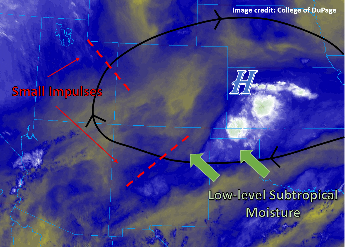
The bulk of the threat today comes from the potential for slow-moving storms atop current and old burn scars, primarily across the southern 1/3rd of the state. The main focus area today is across the Burro and 416 fire areas, where forecast models are in near-unanimous agreement that some thunderstorm activity will occur today. While a widespread soaking rain is not expected, brief heavy rainfall rates of up to 1” per hour will pose a flood threat in and around recent burn areas, where exposed soil, ash, debris, etc. could be quickly swept up in any rain that occurs. In addition, the lift from one or more shortwaves this evening could maintain storm activity into the overnight hours, with some guidance indicating that storms may linger well into tomorrow morning. This is therefore a long-duration threat with potentially significant consequences near active burn scars in the southwestern portion of the state, necessitating a High flood risk today.
A Moderate risk has also been issued for the active Adobe, Weston Pass, Chateau, and Spring Creek fire areas to account for the expected low coverage of thunderstorm activity (isolated to scattered), but with the potential for rainfall rates in excess of 0.5”/hour, which would be more than sufficient to cause some isolated mud flows and debris slides. More broadly, the high terrain of the southern portion of the state has been included in a Low risk for today to account for two potential flood risks today: the chance of isolated rainfall rates of up to 1” per hour in steep terrain and over a handful of old burn scars (e.g., the West Fork Complex in Hinsdale and Mineral counties), as well as the threat of several hours of continuous moderate rainfall overnight, which could cause some notable rises on local creeks and streams. For the most part, however, consequential flooding is expected to be centered around the burn areas.
For more information on timing and rain rates, please see the zone-specific forecast discussions below.
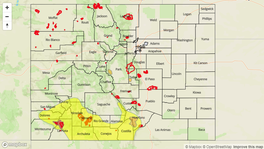
Today’s Flood Threat Map
For more information on today’s flood threat, see the map below (hover over threat areas for more details). For Zone-Specific forecasts, jump below the map.

Zone-Specific Forecasts
Grand Valley, Southwest Slope, Central Mountains, San Juan Mountains, San Luis Valley, and Southeast Mountains:
Clouds will begin building this morning and scattered thunderstorms are expected this afternoon as moisture moves in. Rainfall rates may broadly be expected to range from 0.1” to 0.5” per hour but may locally reach or exceed 1” per hour. Higher terrain may be expected to see the most storms today and tonight, but notable rainfall may also be possible in the high deserts of the San Luis Valley and Grand Valley.
Primetime: 12PM to 9AM tomorrow
Northwest Slope, Northern Mountains, and Front Range:
Largely sunny and hot today over the northwestern and northeastern portions of the state, with highs into the 90s °F across the low country and 60s and 70s °F in the mountains. Expect increasing cloudiness this afternoon as storms form across the mountains, but expect just a very isolated storm risk today.
Urban Corridor, Northeast Plains, Palmer Ridge, Raton Ridge, and Southeast Plains:
Largely sunny and hot today over the eastern portion of the state, with highs into the 90s °F across the low country and 60s and 70s °F in the mountains. Expect increasing cloudiness this afternoon as storms form across the mountains, with the chance for storms on the plains increasing from north to south. Very isolated storms are possible but unlikely in the northern Urban Corridor out to the northeast corner, with better chances from Denver and the Palmer Ridge south to the NM border. Any storms that get going may be capable of producing isolated pockets of rainfall up to 1” per hour.
Primetime: 2PM to 10PM, possibly until 3AM across the Southeast Plains