Issue Date: 6/30/2018
Issue Time: 7:55 AM
A LOW FLOOD THREAT IS FORECAST TODAY FOR PORTIONS OF THE FRONT RANGE, URBAN CORRIDOR, PALMER RIDGE, NORTHEAST PLAINS, SOUTHEAST PLAINS, AND RATON RIDGE.
A large-scale, low pressure trough will traverse the region today, bringing noticeably cooler temperatures and forcing for scattered showers and thunderstorms, mainly along and east of the Continental Divide. Acting alongside the upper-level trough is a weak surface cool front, currently situated roughly west-to-east across central Colorado, and will continue its trek southward through the afternoon. Behind the front, the arrival of cooler, moist air from the east/northeast will be the fuel for a few strong-to-severe thunderstorms this afternoon/evening across eastern Colorado. The stronger storms will be capable of periods of heavy rainfall, large hail, and strong winds, and this storm potential is the culprit behind the low flood threat.
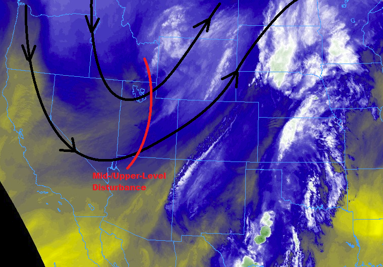
West of the Continental Divide, the cool front and upper-level trough will result in mainly cooler temperatures as the low-levels simply remain too dry for the production of rainfall. The exception to this will be north of I-70, near the best upper-level support, where lift from the trough will be strong enough to generate scattered clouds and isolated showers/garden-variety thunderstorms, resulting in mainly virga and gusty winds with little rainfall.
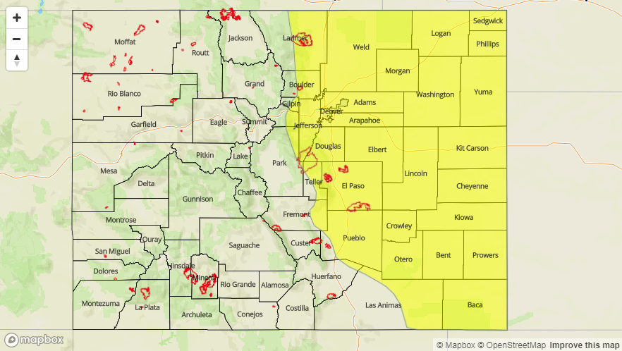
Today’s Flood Threat Map
For more information on today’s flood threat, see the map below (hover over threat areas for more details). For Zone-Specific forecasts, jump below the map.

Zone-Specific Forecasts
Urban Corridor, Palmer Ridge, Northeast Plains, Raton Ridge, and Southeast Plains:
Isolated-to-scattered showers/thunderstorms are expected this afternoon and into tonight, producing periods of moderate-to-heavy rainfall, with the strongest storms capable of large hail (up to 1.75” in diameter) and strong wind gusts (up to 70 mph). An isolated tornado or two cannot be ruled out over the eastern plains (this is Colorado, after all). Maximum rain rates are as follows:
Urban Corridor and Palmer Ridge: 0.8-1.2 inches/hour
Northeast Plains and Southeast Plains: 1.2-1.8 inches/hour
Raton Ridge: 0.6-1.0 inches/hour
Timing: 1 PM – 7 PM for the Urban Corridor, 2 PM – 8 PM for the Palmer Ridge, 2 PM – 11 PM for the Northeast Plains and Southeast Plains, and 1 PM – 8 PM for the Raton Ridge. Outflow boundaries moving back into the foothills during the late evening hours may generate a couple additional storms from 8 PM to Midnight across the southern Urban Corridor, Palmer Ridge, and Southeast Plains.
Front Range and Southeast Mountains:
Isolated-to-scattered showers/thunderstorms are expected this afternoon/evening, with the bulk of the activity over the Front Range due to its close proximity to the upper-level support. Brief periods of moderate-to-heavy rainfall, small hail, and gusty winds are the threats from storms. Maximum rain rates will be 0.6-1.0 inches/hour for the Front Range and 0.35-0.65 inches/hour over the Southeast Mountains.
Timing: 1 PM – 7 PM, with an additional storm or two generated by outflow boundaries moving back into the southern Front Range during the 7 PM – 10 PM timeframe
Northwest Slope, Northern Mountains, Central Mountains, Grand Valley, San Juan Mountains, San Luis Valley, and Southwest Slope:
Noticeably cooler temperatures will be the main weather story today as the cool front pushes through and the upper-level trough passes overhead. Scattered clouds and a few isolated high-based showers/garden-variety thunderstorms will dot the Northern Mountains, higher elevations of the Northwest Slope, and northern portions of the Central Mountains. Due to the relative lack of moisture below cloud bases, virga and gusty winds will be the main result from any activity, with very little rainfall.
Timing: Noon – 6 PM