Issue Date: Friday, June 29, 2018
Issue Time: 08:50AM MDT
— Flooding is NOT expected today
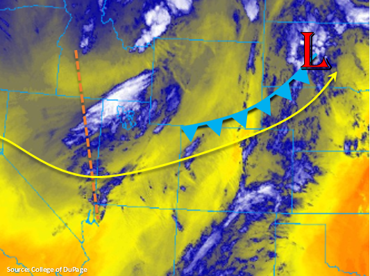
High clouds have made their way into Colorado this morning thanks to a small shortwave that moved through the mid-levels and provided some lift. Flow in the upper atmosphere will be more southwesterly today as the disturbance to our west begins to dig south. The axis of the upper trough is marked with the orange line in the water vapor imagery below. Expect some more shortwave action this afternoon as the disturbance over Utah makes its way into the state. This should help spark some more widespread, high-based thunderstorms this afternoon and evening, especially over the higher terrains. There is also a weak cold front that will affect the northern half of the state today. This should knock down the high temperatures a few degrees, but that’s about all it can muster before it stalls out over the Palmer Divide. Moisture behind the front may increase a little bit, but overall, the lower atmosphere will remain quite dry.
So, as far as moisture goes, there isn’t much over the state. This will limit how much rain the thunderstorms can produce this afternoon. Precipitable Water at Denver this morning was measured at 0.32 inches and was measured at 0.3 inches over Grand Junction. The large spread between the temperature and dew points means the main threat from the storms this afternoon will be gusty winds and plentiful virga. The high-based thunderstorms, gusty winds and low relative humidity will produce extreme fire danger across the majority of the state today prompting a Red Flag Warning.
A lee trough will set up this afternoon over the eastern plains, but it will be far enough east that the higher dew points will stay out of Colorado. Still, this area has the best chance for some measurable rainfall. Expect the storms that move off the higher terrains to strengthen a bit as they reach better moisture over the northwest and southeast corners of the state. These storms should move to east of Colorado by 10PM this evening. Flooding is not forecast today.
Today’s Flood Threat Map
For more information on today’s flood threat, see the map below. For Zone-Specific forecasts, scroll below the map.

Zone-Specific Forecasts:
Front Range, Urban Corridor, Palmer Ridge, Northeast Plains, Southeast Plains, Southeast Mountains, Raton Ridge, San Luis Valley:
The heat is back again today. Over the northern portion of the state, the high temperature should decrease a little with the passage of a weak cold front this afternoon. However, the Southeast Plains are expected to hit 100F+ again. High-based thunderstorms will bring gusty winds to the higher terrains this afternoon. A Red Flag warning has been issued for critical fire weather over the Southeast Mountains, and breezy, dry conditions will not be helpful for the fight against the Spring Fire in Costilla County. The best chance for measurable rain will be over the far eastern plains with max 1-hr rain rates up to 0.4 inches/hour. To the west, total rainfall will be under 0.1 inches with most areas receiving abundant virga. Flooding is not expected today.
Primetime: 1PM to 10 PM
San Juan Mountains, Northern Mountains, Southwest Slope, Grand Valley, Central Mountains, Northwest Slope:
Dry, breezy conditions will place all of these regions under a Red Flag Warning today. The trough to the west will continue to tighten and increase wind speeds through tonight especially over the Northwest Slope. High temperatures will be a couple degrees cooler today, and cloud cover will increase over the higher terrains this afternoon. The strongest cloud cover and best chance for virga (and stronger winds) will be over the San Juan Mountains and Northwest Slope. Rain is not expected today.