Issue Date: Monday, June 25, 2018
Issue Time: 08:30AM MDT
— Flooding is NOT expected today
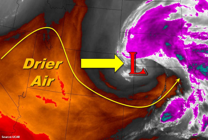
The upper level low that brought widespread showers to the eastern portion of the state and cooler temperatures will begin to move to the east today. That also means the trailing showers over the eastern plains will come to an end this afternoon. Behind the low, a ridge (marked in the water vapor imagery below) will begin to slide over the state and promote northwesterly flow aloft. Dry air and general subsidence will cease shower and thunderstorm activity over the state today. Expect a few cumulus clouds over the higher terrains this afternoon, but it should remain clear elsewhere. Temperatures will also be on the rise heating up 10-15F when compared to yesterday. To the west, the eastward movement of the jet stream means a break from widespread critical fire weather. Though, some isolated ridgetop gusts up to 25 mph are expected this afternoon. Flooding is not forecast today.
Today’s Flood Threat Map
For more information on today’s flood threat, see the map below. For Zone-Specific forecasts, scroll below the map.

Zone-Specific Forecasts:
Northeast Plains:
Spotty showers continue over the Northeast Plains that are associated with the upper level low. They will continue their eastward progression throughout the morning into the early afternoon. Cloud cover will keep temperatures a bit cooler today. Totals up to 0.25 inches are possible, but flooding is not expected.
Primetime: Ongoing to 4PM
Front Range, Urban Corridor, Southeast Mountains, Raton Ridge, Southeast Plains, Palmer Ridge:
Showers and thunderstorms are not expected today as general subsidence and drier air moves into the state. Temperatures will start to increase (10-15F) with highs much closer to normal for this time of year. A few cumulus may form over the higher terrains and Palmer Ridge this afternoon, but it should remain clear elsewhere.
San Luis Valley, San Juan Mountains, Northern Mountains, Southwest Slope, Grand Valley, Central Mountains, Northwest Slope:
As the upper level jet slides east, there will be a break in widespread critical fire weather. There is still a chance for some gusts over the high ridges this afternoon, but it should remain calm otherwise. Temperatures are forecast to reach 90F in the valleys and 65-70F over the higher terrains. Clear skies overnight will allow temperatures to drop into the mid 50Fs and 60Fs.