Issue Date: 6/24/2018
Issue Time: 9:32 AM
A LOW FLOOD THREAT HAS BEEN ISSUED FOR PORTIONS OF THE URBAN CORRIDOR, PALMER RIDGE, NORTHEAST PLAINS, SOUTHEAST PLAINS, AND RATON RIDGE.
An active day of showers and thunderstorms is expected as the upper-level low currently situated over Wyoming shifts eastward, reaching north-central Nebraska later tonight. As it does so, broad-scale support will be in place across Colorado, with a shortwave axis acting as the trigger for scattered-to-widespread showers and thunderstorms today and into the late evening hours. Isolated-to-scattered showers/thunderstorms will get their start over the Northern Mountains, Central Mountains, and Front Range during the late morning hours (11 AM – Noon), with those storms moving eastward with time. This early activity will be capable of gusty winds, lightning, and periods of light-to-moderate rainfall, but not much more. Showers/storms will continue over these regions through the afternoon, diminishing during the early evening hours.
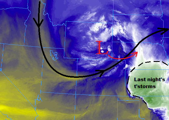
The main show today will occur east of the mountains, where better moisture, instability, and favorable wind shear coincide with the passage of the upper-level low. Scattered-to-widespread showers and thunderstorms are expected to kick off around lunchtime, increasing in coverage through the afternoon and early evening hours, tracking generally eastward with time. The strongest storms of the day will occur over southern portions of the Northeast Plains, eastern portions of the Palmer Ridge, and across the Southeast Plains and Raton Ridge, where the best instability resides. Strong winds, large hail, and periods of moderate-to-heavy rainfall will attend this activity. Relatively quick storm motions will help mitigate the flood threat, so only a low flood threat is warranted. Activity will diminish from northwest to southeast, with storms ending/exiting the state completely by 11 PM.
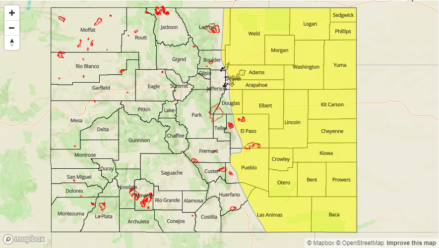
Today’s Flood Threat Map
For more information on today’s flood threat, see the map below (hover over threat areas for more details). For Zone-Specific forecasts, jump below the map.

Zone-Specific Forecasts
Urban Corridor, Palmer Ridge, Northeast Plains, Raton Ridge, and Southeast Plains:
Scattered showers and thunderstorms are expected, beginning around lunchtime over the Urban Corridor and Palmer Ridge, developing and spreading eastward with time. The strongest storms of the day are expected over eastern portions of the Palmer Ridge, southern portions of the Northeast Plains, Raton Ridge, and the Southeast Plains. Large hail, strong winds, and an isolated tornado or two cannot be ruled out. Maximum rain rates are as follows:
Urban Corridor: 1.0-1.4 inches/hour
Northeast Plains and Palmer Ridge: 1.2-1.6 inches/hour
Southeast Plains and Raton Ridge: 1.8-2.2 inches/hour
The main threats will be street/field ponding in poorly drained areas, flooding of low-lying areas and intersections, and small stream/creek flooding. Relatively quick storm motions to the east will mitigate the flood threat somewhat, as heavy rainfall residence time will be reduced.
Timing: 11 AM – 9 PM for the Urban Corridor and Palmer Ridge, Noon – 9 PM for the Northeast Plains, 1 PM – 11 PM for the Southeast Plains, and 3 PM – 11 PM for the Raton Ridge.
Northwest Slope, Northern Mountains, Central Mountains, Front Range and Southeast Mountains:
Isolated-to-scattered showers/thunderstorms are expected to begin late this morning and continue into the evening hours. Most showers/storms will be garden variety, producing gusty winds and periods of light rainfall. A stronger thunderstorm or two over the Front Range and Southeast Mountains will be capable of producing small hail, brief moderate rainfall, and strong winds. Maximum rain rates are as follows:
Front Range and Southeast Mountains: 0.4-0.7 inches/hour
Northern Mountains, Central Mountains: 0.2-0.4 inches/hour
Northwest Slope: 0.05-0.15 inches/hour
Timing: 11 AM – 7 PM for the Northwest Slope and Northern Mountains, 11 AM – 9 PM for the Front Range and Central Mountains, and 1 PM – 10 PM for the Southeast Mountains
Grand Valley, San Juan Mountains, San Luis Valley, and Southwest Slope:
Mostly sunny, cooler, and dry will be the name of the game today. High temperatures will be about 4-8 degrees cooler than average.