Issue Date: 6/17/2018
Issue Time: 9:30 AM
A MODERATE FLOOD THREAT HAS BEEN ISSUED FOR PORTIONS OF THE FRONT RANGE, URBAN CORRIDOR, NORTHEAST PLAINS, AND PALMER RIDGE.
A MODERATE FLOOD THREAT HAS BEEN ISSUED FOR THE 416 FIRE AND BURRO FIRE AREAS.
A LOW FLOOD THREAT HAS BEEN ISSUED FOR PORTIONS OF THE NORTHERN MOUNTAINS, CENTRAL MOUNTAINS, FRONT RANGE, URBAN CORRIDOR, PALMER RIDGE, NORTHEAST PLAINS, AND SOUTHEAST PLAINS.
Remnants of Bud will continue to overlay the state today, with the best mid-level moisture shifted to the east as compared to the previous FTB period. Drier air is currently working its way in from eastern Utah, which will eventually eliminate the flood threat for the 416 Fire and Burro Fire during the evening hours. The main features to focus on for today’s main show, however, is the surface low and associated cool frontal boundary across eastern Colorado. I have denoted the location of these features, as of 8:16 AM MDT, in the surface map below. The surface convergence and wind shear along the frontal boundary, coinciding with the passage of the mid-/upper-level low this afternoon, will provide the trigger for scattered-to-widespread showers and thunderstorms today/tonight along, and to the north of, the frontal boundary.
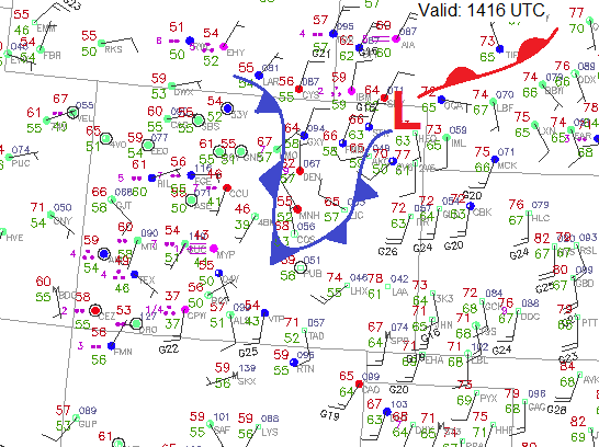
The front isn’t expected to move much, perhaps sag southward a few miles, so the threat of training thunderstorms riding the boundary (northeast storm motions on a southwest-to-northeast oriented boundary) is the culprit behind today’s moderate flood threat. Plenty of moisture is in place for heavy rainfall, with precipitable water values ranging from 1.0 to 1.4 inches expected across the threat area.
Burro Fire and 416 Fire burn areas:
Flash flooding, debris, and rocks were reported across Highway 550 just north of Durango this morning. With the threat of rainfall still in the forecast through the afternoon hours, the moderate flood threat has been issued. The threat today is less than yesterday due to drier air moving in from the west, but with the rain that has already fallen, it will take even less today to produce more issues.
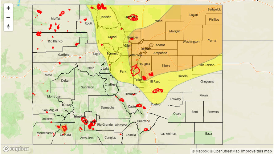
Today’s Flood Threat Map
For more information on today’s flood threat, see the map below (hover over threat areas for more details). For Zone-Specific forecasts, jump below the map.

Zone-Specific Forecasts
Northern Mountains, Central Mountains, Front Range, Urban Corridor, Palmer Ridge, Northeast Plains, Southeast Mountains, Raton Ridge, and Southeast Plains:
Along and north of the frontal boundary, scattered-to-widespread showers and thunderstorms are expected. With precipitable water values exceeding 1 inch, and ranging up to 1.4 inches near the CO/KS/NE border, rainfall production will be very efficient. The threat of training showers/thunderstorms producing periods of heavy rainfall is the culprit behind the moderate flood threat. To the south of the frontal boundary, a lack of focusing mechanism for shower/thunderstorm development will keep activity for isolated and sporadic. Maximum rain rates are as follows:
Northern Mountains, Central Mountains, and Front Range: 0.8-1.2 inches/hour
Urban Corridor and Palmer Ridge: 1.0-1.3 inches/hour
Northeast Plains: 1.5-2.0 inches/hour
Southeast Plains: 0.8-1.4 inches/hour
Raton Ridge and Southeast Mountains: 0.2-0.4 inches/hour
Threats: Flash flooding, street/field ponding (especially in poorly drained areas/intersections), low-lying area flooding along streams/creeks, mud flows/debris slides from impacted burn scars in steep terrain.
Timing: Noon – Midnight for the mountains, with a few showers/weak storms lingering into the early morning hours. Noon – 1 AM for all other areas, with a few storms over the Urban Corridor and Northeast Plains until 5 AM.
Northwest Slope, Grand Valley, San Juan Mountains, San Luis Valley, and Southwest Slope:
Isolated-to-scattered showers are expected today, with a few weak thunderstorms mixed in during the afternoon hours. Drier air is beginning to make its way in from Utah, so activity will end from west-to-east during the late afternoon and into the evening hours. Generally speaking, rainfall rates will be 0.1-0.3 inches/hour, with maximum rain rates as follows:
Northwest Slope and Grand Valley: 0.4-0.8 inches/hour
Southwest Slope and San Juan Mountains: 0.3-0.6 inches/hour
San Luis Valley: 0.2-0.4 inches/hour
Timing: Ongoing – 11 PM, with activity diminishing from west to east beginning around 5 PM.