Issue Date: 6/16/2018
Issue Time: 9:10 AM
8:15 PM UPDATE:
The event has not evolved exactly as expected, as cloud cover limited instability during the afternoon and early evening hours. This limited instability, combined with a more aggressive dry slot in the mid-level moisture has kept precipitation over the eastern Southwest Slope and San Juan Mountains to a minimum, and kept most of the precipitation to the west and north.
With that said, the High Impact Flood Threat remains in effect for the 416 Fire and the High Flood Threat remains in effect for the Burro Fire. Moisture is expected to rebound during the overnight hours, coupled with broad, mid-level support. This will set up an axis of showers and one or two thunderstorms, oriented southwest-to-northeast across western Colorado. This axis of showers/thunderstorms will be the one to watch. If it sets up to the west of the High Impact/High Flood threat areas, a bullet will have been dodged. If this sets up over the 416 Fire and Burro Fire, it will likely produce enough rain for all of the threats discussed earlier (flash flooding, mud flows, and debris slides). The areas are not out of the woods yet, so to speak. The prime time for this threat is Midnight – 6 AM, but the flood threat will remain in effect until 11 AM.
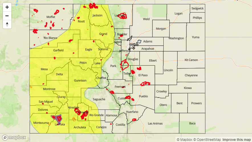
A HIGH IMPACT FLOOD THREAT IS FORECAST TODAY FOR PORTIONS OF THE SOUTHWEST SLOPE AND SAN JUAN MOUNTAINS – NAMELY FOR THE 416 FIRE AND LOCATIONS IMMEDIATELY DOWNSTREAM.
A HIGH FLOOD THREAT ENCOMPASSES THE BURRO FIRE AND LOCATIONS IMMEDIATELY DOWNSTREAM.
A LOW FLOOD THREAT SURROUNDS THESE AREAS AND INCLUDES PORTIONS OF THE NORTHERN MOUNTAINS, NORTHWEST SLOPE, GRAND VALLEY, CENTRAL MOUNTAINS, SOUTHWEST SLOPE, AND SAN JUAN MOUNTAINS.
Note: If necessary, a PM Update will be issued if the forecast deviates significantly.
Today begins the start of a wetter and cooler period for Colorado, and on most counts that is a good thing. 67% of the state, according to the United States Drought Monitor, is experiencing drought conditions. Rain is good. However, because of the dry conditions, two wildfires in particular have raged – the Burro Fire and the 416 Fire – and these burn scars (and points immediately downstream) are under the gun for flash flooding, mud flows, and debris slides through this FTB period.
A few major features, highlighted in the water vapor image below, are coming together to result in today’s flood threat. The remnants of Hurricane Bud are being pulled northward into Colorado by the upper-level low over the Pacific Northwest and a secondary, upper-level low circulation over the Californian Baja. These upper-level lows will provide ample, broad scale support for showers and thunderstorms across the state today/tonight, and the depth of the moisture being transported into the state will lead to efficient rainfall production. Pockets of precipitable water values over an inch have already begun invading southwest Colorado this morning, and those values will continue to spread northward throughout the day.

Additionally, for eastern Colorado, low-level moisture will be pulled in from the Great Plains. This will mainly impact the Northeast Plains and Urban Corridor, where a couple strong-to-severe storms will also be possible.
Burro Fire and 416 Fire burn areas:
Both fire burn areas, and locations immediately downstream, are under the High/High Impact Flood Threat today. It will only take rain rates of 0.25-0.5 inches/hour to produce flash flooding, mud flows, and debris slides, and those rates occur often when precipitable water values exceed 1 inch. Residents near these burn scars, especially those along the Highway 550 corridor including Hermosa need to be prepared. Durango, out of an abundance of caution since this is the first rainfall event over these burn scars, needs to be prepared, as well.
Today’s Flood Threat Map
For more information on today’s flood threat, see the map below (hover over threat areas for more details). For Zone-Specific forecasts, jump below the map.

Zone-Specific Forecasts
Front Range, Southeast Mountains, Urban Corridor, Palmer Ridge, Northeast Plains, Southeast Plains, and Raton Ridge:
Scattered showers and thunderstorms are expected today/tonight. Most will be garden-variety, producing gusty winds and light-to-moderate rainfall. A few stronger thunderstorms will rumble, mainly north of I-70, producing small hail, strong winds, and brief periods of heavy rainfall. Most activity will come to an end by midnight, but a few lingering showers/weak thunderstorms will continue into the overnight/early morning hours. Relatively quick storm motions preclude the issuance of a flood threat. Maximum rain rates are as follows:
Front Range, Urban Corridor, and Palmer Ridge: 0.4-0.8 inches/hour
Northeast Plains: 1.0-1.5 inches/hour
Southeast Mountains: 0.25-0.5 inches/hour
Raton Ridge and Southeast Plains: 0.5-0.8 inches/hour
Timing: Noon – 11 PM, with a few lingering showers/weak thunderstorms into the early morning hours
Northern Mountains, Northwest Slope, Central Mountains, Grand Valley, San Juan Mountains, San Luis Valley, and Southwest Slope:
Scattered-to-widespread showers and thunderstorms are expected. The Burro Fire and 416 Fire burn areas are under the gun today, due to their sensitivity to rainfall and the likely multiple rounds of showers/storms that will impact the area throughout this FTB period. 0.25-0.5 inches/hour rain rates are all it will take, and those rates will likely be exceeded by thunderstorm activity in the area. Flash flooding, mud flows, and debris slides are all threats in those areas.
Elsewhere across the High Country, other areas with steep terrain and burn scars will need to be monitored. The low flood threat is a result of this event being more of a 24-hour event rather than a 1-hour rainfall event. Widespread areas of 0.25-0.75 inches of rain are likely, with localized areas of 1-2 inches of rainfall possible.
Maximum rain rates are as follows:
Southwest Slope, San Juan Mountains, Central Mountains, Grand Valley, and Northern Mountains: 0.5-1.0 inches/hour
Northwest Slope: 0.4-0.7 inches/hour
San Luis Valley: 0.2-0.5 inches/hour
Timing: 11 AM – 11 AM