Issue Date: 6/05/2015
Issue Time: 10:58 AM (Updated 2:50PM)
— Moderate flood threat for Urban Corridor, Palmer Divide, Southeast Plains and parts of Raton Ridge
— Low flood threat for San Juan Mountains
— Low flood threat for parts of Grand Valley for potential landslide
Afternoon update: Thunderstorms continue to fire, in association with small-scale upper-level disturbances entering the state from the southwest. Individual storms will be capable of producing very heavy rainfall, up to 1.8 inches per hour, such as is being reported in the Denver Metro area, as well as over the Raton Ridge. However, widespread flooding is NOT anticipated. Isolated tornadoes and very large hail, up to 2.5 inches, will accompany the strongest storms.
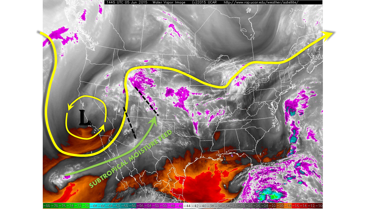
An impressive persistence in very moist conditions east of the Divide is now enveloping most of the state. This is associated with a dual combination of an approaching upper-level cyclone over California and a connection to subtropical moisture from the eastern Pacific. The upper-level cyclone is in no hurry to move, and despite very slowly weakening, it will impact our weather today and for the next two days (see a more detailed discussion in our Flood Threat Outlook from Thursday, 6/4). The water vapor image below shows the aforementioned features as well as two specific disturbances: one crossing over Colorado currently, the other approaching the Four Corners and impacting our state this afternoon.
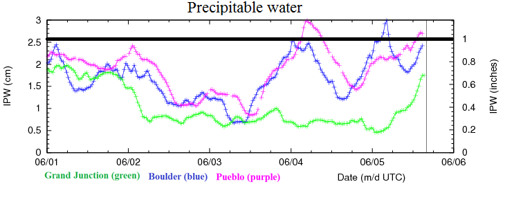
Meanwhile, a chart of the precipitable water, below, shows a roller coaster ride over the last several days. Note that Pueblo now sits over 1 inch, with Boulder fast approaching that. Grand Junction has seen a tremendous spike in moisture with values of 0.2 inches yesterday, but up to 0.7 inches this morning. The atmosphere is getting primed for showers and thunderstorms.
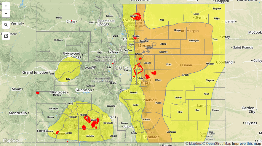
 Shower and thunderstorm activity is already ongoing both east and west of the Continental Divide. With limited instability, this activity is only mustering rain rates of up to 0.4 inches per hour. However, as partial sunshine and the atmosphere’s dynamics work in tandem today, we expect repeated rounds of thunderstorms over many parts of the state. The extreme southeast and northwest corners will be generally quieter. Hourly rain rates up to 1.8 inches, and 3-hourly rain rates up to 3.00 inches warrant a Moderate flood threat across a large swath of eastern Colorado. The San Juan region is under a Low threat for persistent light to moderate rainfall that will fall on top of the remaining snow pack.
Today’s Flood Threat Map
For more information on today’s flood threat, see the map below (hover over threat areas for more details). For Zone-Specific forecasts, jump below the map.

Zone-Specific Forecasts
Front Range, Urban Corridor, Northeast Plains, Palmer Divide, Southeast Plains, Southeast Mountains and Raton Ridge:
Partly to mostly cloudy skies with repeated rounds of shower and thunderstorm activity. Hourly rain rates up to 1.8 inches possible, with 3-hr rates up to 3.0 inches. Short-term heavy rainfall rates, up to 0.5 inches in 5-10 minutes are possible. Hail, up to 2 inches cannot be ruled out in the afternoon, along with a slight tornado threat. A Moderate flood threat is in place for a large part of the region, with a Low threat elsewhere. The extreme southeast will likely see some drier air infiltrate, limiting rainfall chances.
Primetime: 2pm through 11pm
San Luis Valley, Central Mountains, Northern Mountains, Grand Valley and Northwest Slope:
Partly to mostly cloudy skies with intermittent rain showers and weak thunderstorms. Coverage and intensity will increase throughout the day. Hourly rain rates up to 0.6 inches possible. A Low flood threat is in effect for parts of the Grand Valley for a potential landslide from additional rainfall. Otherwise, no other flooding is expected.
San Juan Mountains and Southwest Slope:
Partly to mostly cloudy with repeated rounds of showers and thunderstorms for a majority of the day and into the night. Hourly rainfall rates up to 0.8 inches possible, with 3-hourly rainfall up to 1.4 inches warranting a Low flood threat. Rainfall will fall over the remaining snowpack and may cause localized minor flooding in streams.