Issue Date: Friday, June 8, 2018
Issue Time: 09:00AM MDT
— Flooding is NOT expected today
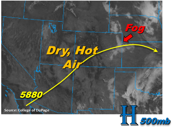
The visible satellite imagery below shows some dense fog over the eastern plains to start the day. This should quickly burn off this morning with the onset of daytime heating. Elsewhere, it is crystal clear over the state and the southwest US. This is noteworthy because it shows the lack of moisture left under the ridge. For today, the stubborn ridge continues to build over the state with the 5880 meter line making its way to the northern Colorado border. Southwesterly flow begins to become more westerly this afternoon, which should push the high moisture east of the state. There still may be some moist, low-level easterly flow over the far northeastern plains, but expect higher dew points to remain east over Kansas. Most storms that fire over the higher terrains this afternoon will evaporate before they are able to drop any rainfall; however, this will provide some shade from the well above average temperatures. High temperatures and low moisture means rainfall is expected to be even more isolated in coverage this afternoon when compared to yesterday. The best chance for measurable rainfall today is over the southeast corner of the state and Cheyenne/Kit Carson/Yuma Counties. Flooding is not expected today.
Today’s Flood Threat Map
For more information on today’s flood threat, see the map below. For Zone-Specific forecasts, scroll below the map.
Zone-Specific Forecasts:
Palmer Ridge, Front Range, Urban Corridor, Northeast Plains, Southeast Plains, Raton Ridge, Southeast Mountains:
Very isolated shower and thunderstorm coverage today with westerly flow off the mountains mixing out moisture eastwards. Best storm coverage today will be over the eastern Palmer Ridge and southeast corner of the state. High rainfall is expected to remain east of Colorado. Max 1-hour rain rates up to 0.7 inches are possible further east, but outflow driven storms will likely produce 1-hour rain rates in the 0.3 to 0.5 inch/hour range. Flooding is not expected today.
Primetime: 4PM – 9PM
San Luis Valley, San Juan Mountains, Northern Mountains, Southwest Slope, Grand Valley, Central Mountains, Northwest Slope:
Dense Smoke Advisory continues for the valleys near the 416 fire this morning. Smoke is expected to decrease as drainage winds will shift later this morning. Expecting another day of hot and dry weather. The cloudless skies across the southwestern US indicate the clear skies over western Colorado will continue throughout the day. Rainfall is not expected.