Issue Date: Friday, May 25, 2018
Issue Time: 08:30AM MDT
— Flooding is NOT expected today
— Elevated Fire Danger for Colorado through Saturday night
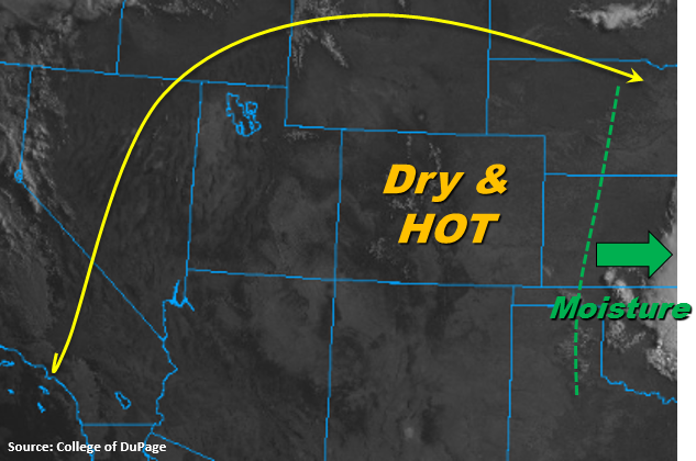
It’s going to be dry and hot to kick off Memorial Day weekend across Colorado. The visible image below shows clear skies this morning thanks to the building ridge to our east. Temperatures are expected to reach 85-90F in the low elevations and valleys today with highs in the mountains reaching the mid to upper 60s. Soundings at Denver and Grand Junction this morning confirm dry air throughout the atmosphere. So other than a few cumulus this afternoon over the mountains and elevated ridges, it should be a severe clear day across the state. There is a small outside chance for an isolated thunderstorm over the Palmer Divide/eastern Plain intersect, but rain totals will be under 0.1 inches. These storms are expected to provide more shade from the heat than rainfall.
The main weather concern going into this weekend is elevated fire danger. Low relative humidity values and increasing winds through Saturday night will place most of the state under a Red Flag Warning. Outdoor enthusiasts, please use extra caution this weekend with any activities that may start a fire.
Today’s Flood Threat Map
For more information on today’s flood threat, see the map below. For Zone-Specific forecasts, scroll below the map.

Zone-Specific Forecasts:
Palmer Ridge, Front Range, Urban Corridor, Northeast Plains, Southeast Plains, Southeast Mountains, Raton Ridge:
Very hot temperatures today with the building ridge. Some afternoon cumulus will pop up over the mountains and elevated ridges, but rain is not expected. Skies should clear overnight. There is increased fire danger through Saturday night, and a Red Flag Watch has been issued for this time period. Please use extra caution when burning this weekend.
San Luis Valley, San Juan Mountains, Central Mountains, Southwest Slope, Northwest Slope, Grand Valley, Northern Mountains:
Expect a few broken clouds over the higher terrains this afternoon, but clear and hot conditions at the lower elevations. Red Flag Warnings have already been issued through Saturday night as breezy conditions and low relative humidity create critical fire danger.