Issue Date: 5/23/2018
Issue Time: 7:45 AM
NO FLOOD THREAT IS FORECAST TODAY.
NOTE: THE ANNUAL FLUSH OF CHERRY CREEK WILL OCCUR TODAY. 1300 CFS WILL BE RELEASED FROM CHERRY CREEK DAM, POTENTIALLY CAUSING BIKE PATH AND STREAM CROSSING CLOSURES ALONG THE CHERRY CREEK TRAIL.
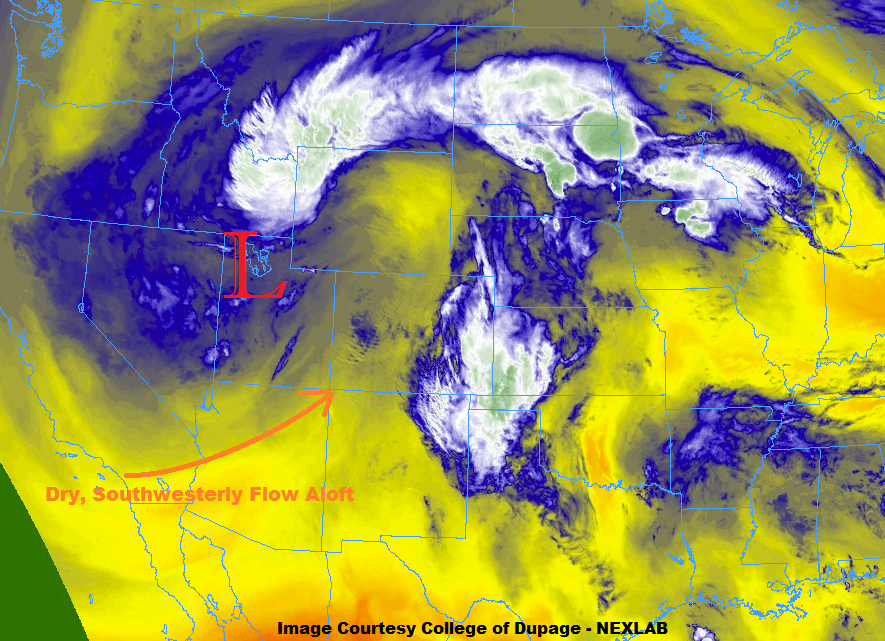
The upper-level low that was centered over the Great Basin yesterday has weakened and is lifting off to the northeast, as denoted by the red “L” in the water vapor image below. As it does so, it will place Colorado under drier, southwesterly flow aloft (orange arrow), which will suppress thunderstorm development across much of the Colorado High Country. The exception to this rule will be a few isolated thunderstorms north of I-70, thanks being nearer the broad upper-level support provided by the decaying upper-level low and a weak shortwave expected to pass overhead during the afternoon hours.
East of the mountains, isolated afternoon/evening thunderstorms are expected thanks to the presence of convergence along a surface low-pressure trough/dryline. The drier, southwesterly flow aloft will mix down into the low-levels and scour out the moisture, much like across western Colorado, but thanks to low-level easterly flow east of the dryline, some moisture will be able to hang on. Due to the expected surface wind fields, the best opportunity for isolated thunderstorms will be east of a line from Cheyenne-Fort Collins-Boulder-Castle Rock-Limon-La Junta-Trinidad. For more specifics on rain rates and timing, please see the zone-specific forecast discussions below.
Today’s Flood Threat Map
For more information on today’s flood threat, see the map below (hover over threat areas for more details). For Zone-Specific forecasts, jump below the map.


Zone-Specific Forecasts
Front Range, Urban Corridor, Northeast Plains, Southeast Plains, Palmer Ridge, and Raton Ridge:
Isolated-to-widely scattered thunderstorms are expected to rumble during the afternoon/evening hours, breaking up the otherwise mostly sunny, dry, and warm day across the area. A few storms will be on the strong-to-severe side, producing hail, strong winds, and periods of moderate-to-heavy rainfall. Due to the risk of small hail, be on the lookout for street/field ponding where hail accumulates and clogs drainage. Maximum rain fall rates will be as follows:
Front Range: 0.2-0.4 inches/hour
Urban Corridor, Palmer Ridge, and Raton Ridge: 0.4-0.8 inches/hour
Northeast Plains and Southeast Plains: 1.0-1.35 inches/hour
Timing for Front Range: 11 AM – 7 PM
Timing for Urban Corridor and Palmer Ridge: Noon – 8 PM
Timing for Northeast Plains, Southeast Plains, and Raton Ridge: 1 PM – 11 PM
Northwest Slope and Northern Mountains:
Isolated-to-widely scattered showers/thunderstorms are expected to begin during the late morning hours, continuing into the late evening hours. The higher terrain has the best chance at any wetting rainfall, while lower valleys will feel the gusty winds and notice a sprinkle or two with plenty of virga to go around. Rainfall rates will generally remain low, with maximum rates of 0.2-0.4 inches/hour.
Timing: 10 AM – 8 PM
Central Mountains, Grand Valley, Southwest Slope, San Juan Mountains, Southeast Mountains, San Luis Valley:
A warming and drying trend begins as drier, southwesterly flow aloft invades the region. Cumulus clouds will bubble over the higher terrain in the afternoon/evening warmth, resulting in streaks of virga and perhaps a sprinkle or two over the higher terrain of the Central Mountains and Grand Valley. Otherwise, dry conditions will prevail.