Issue Date: 5/13/2018
Issue Time: 10:15 AM
— LOW flood threat for the Front Range, Urban Corridor, and Northeast Plains today.
The upper-level low pressure system that has been responsible for rain and thunderstorms across the state over the last few days continues to spin in place over Idaho, Utah, and Nevada. This has kept dry southwesterly flow aloft over much of Colorado, resulting in largely dry conditions in the high country with instability over the plains. For those in the northeastern portion of the state, this morning has looked like a rerun of yesterday, with easterly upslope winds near the surface resulting in fog, low stratus clouds, and drizzle/light rain for the Urban Corridor and eastern plains. As indicated on the image below, low-level moisture has extended further south today, over the Palmer Divide and into the southeastern portion of the state.
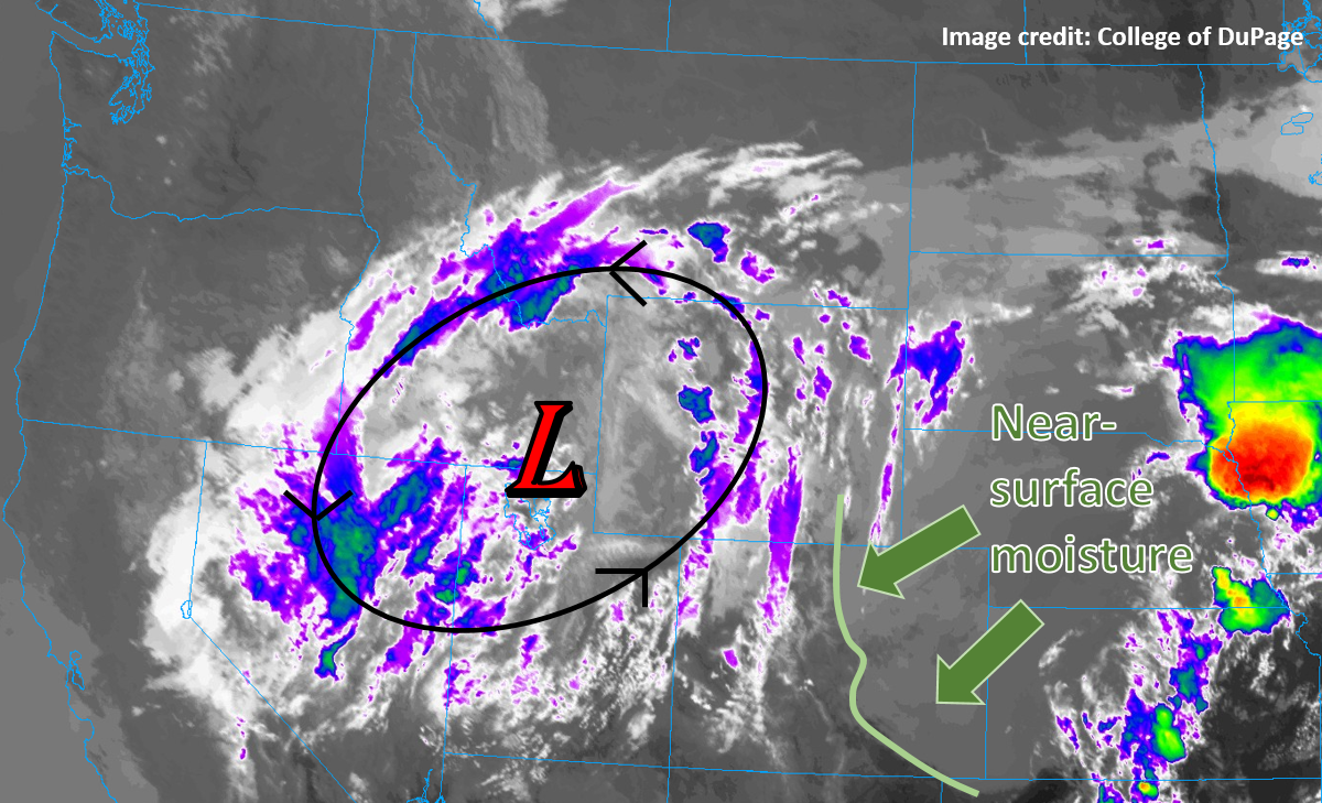
As the sun angle increases throughout the day, expect much of this fog and low-level cloud cover to burn off. Instability will increase as the surface heats, particularly along the northern Front Range and northern plains, enabling the development of scattered thunderstorms this evening. The Storm Prediction Center has indicated that there is potential for some stronger and better-developed thunderstorms to pose a brief severe weather risk along the northern Front Range and Urban Corridor, with hail, strong winds, and a brief tornado all possible. Later in the evening and after sunset, storms are expected to persist, transitioning into more of a flood threat as they grow into clusters that may produce several bouts of brief heavy rainfall over the same areas.
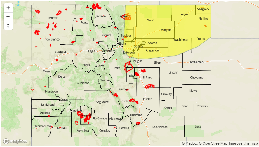
Today’s Flood Threat Map
There is a LOW flood threat over the northeastern corner of the state today. For more information on today’s flood threat, see the map below (hover over threat areas for more details). For Zone-Specific forecasts, jump below the map.

Front Range, Urban Corridor, Northeast Plains, Palmer Ridge:
The drizzle, low cloud, and fog this morning will gradually lift and thin throughout the day, and there may be a few hours of sunshine around mid-day. Clouds will build back in as thunderstorms initiate this afternoon, with rain scattered at first and becoming more widespread through the evening. Rain could linger into the early morning hours of Monday. Rainfall rates this evening will widely be in the 0.25-0.50” per hour range, but may briefly approach 1.00” per hour. Moderate to heavy rain rates may persist for a few hours, leading to an isolated nuisance flooding and road ponding threat.
Primetime: 4PM to 4AM Monday
Northwest Slope, Northern Mountains, Central Mountains:
Partly cloudy with a chance of some showers building in later in the day and overnight, transitioning to snow above 11,000 feet this evening. Rainfall rates should be low, mainly in the 0.05-0.15” per hour range.
Primetime: 12PM to 9PM
Southeast Mountains, Southeast Plains, Raton Ridge, Grand Valley, Southwest Slope, San Juan Mountains, San Luis Valley:
Low-level cloudiness on the Southeast Plains this morning will quickly erode from the southwest, leaving much of the southern half of the state sunny and dry. Expect a few fair-weather cumulus to develop over the mountains during the afternoon, and clouds may build back from the northeast over the plains tonight.