Issue Date: 5/1/2018
Issue Time: 9:20 AM
Welcome back to the 2018 FTB season. We look forward to another successful season serving you.
NO FLOOD THREAT IS FORECAST.
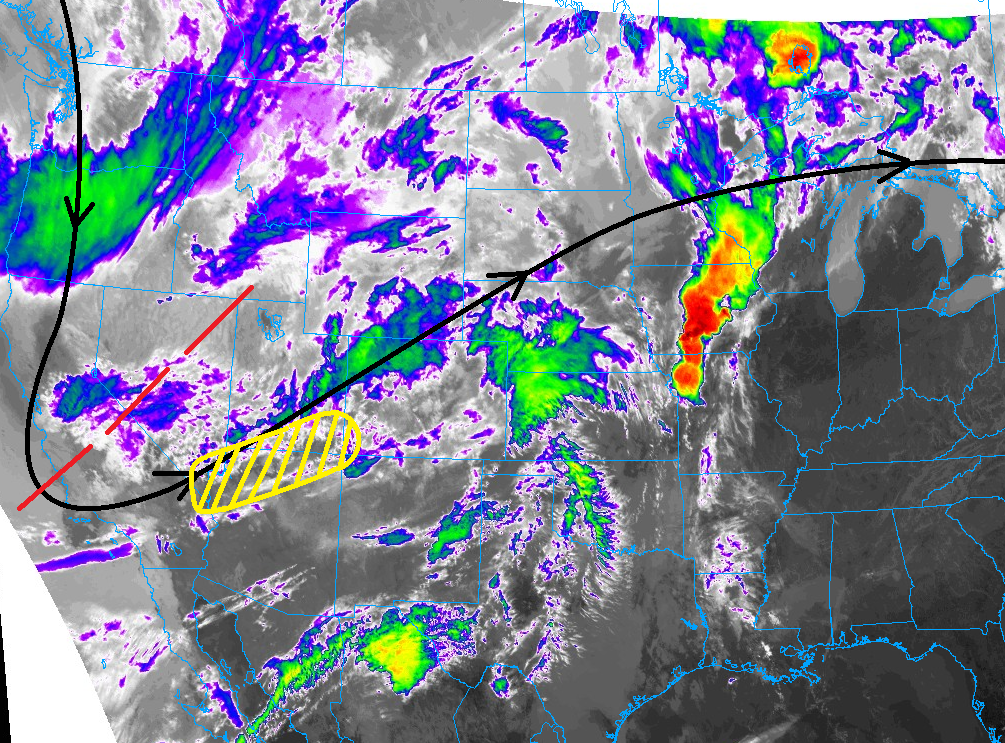
It is only fitting that Mother Nature would welcome the FTB back with a day of weather that ranges from fire weather conditions to showers/thunderstorms, and even a severe storm or two. In the infrared imagery below, we can gather a bit of information on why unsettled weather is in the forecast. The upper-level trough axis, denoted by the red-dashed line, will swing towards the east/northeast today, with a jet streak (denoted by the yellow-dashed region) that will nose into Colorado, providing upper-level support for showers/thunderstorms across the high country and northeast Colorado.
Generally speaking, the activity over the much of the high country will be in the form of garden variety showers, producing mainly gusty winds and periods of light rainfall. The exception to this will be over the Front Range, where an isolated thunderstorm or two will produce lightning, gusty winds, and a brief period of moderate rainfall. Out over the Urban Corridor and Northeast Plains, scattered showers and thunderstorms are expected, with a couple reaching severe thresholds (strong winds, hail up to 1.25 inches, isolated tornado). More details on the timing and rain rates can be found in the zone-specific forecast discussions below.
For Southeast Colorado, namely the Southeast Plains and Raton Ridge regions, dry and windy conditions will exist, resulting in increased fire danger through today and into the evening hours tonight, before slightly better moisture returns as a cold front moves in from the north and reduces the fire danger risk.
Today’s Flood Threat Map
For more information on today’s flood threat, see the map below (hover over threat areas for more details). For Zone-Specific forecasts, jump below the map.


Zone-Specific Forecasts
Front Range, Urban Corridor, and Northeast Plains:
Scattered showers/thunderstorms are expected today/tonight, kicking off just before lunch time (10-11 AM) over the Front Range and then spreading over the Urban Corridor around Noon and then into the Northeast Plains by 1-2 PM. Brief periods of moderate rainfall will occur underneath the strongest storms, but fairly quick storm motions will keep rainfall below flash flood thresholds. Some street/field ponding in poorly drained areas can be expected under the strongest thunderstorms. The peak of thunderstorm coverage will occur during the late afternoon/early evening hours, winding down by the late evening hours, with only isolated activity persisting until midnight. A stray shower or two cannot be ruled out for the morning hours tomorrow. Maximum rain rates are as follows:
Front Range: 0.25-0.5 inches/hour
Urban Corridor: 0.3-0.6 inches/hour
Northeast Plains: 0.75-1.25 inches/hour
Timing: 10 AM – 10 PM for the Front Range, Noon – Midnight for the Urban Corridor, and 1 PM – Midnight for the Northeast Plains
Palmer Ridge, Raton Ridge, San Luis Valley, and Southeast Plains:
Dry conditions are on tap for today, especially for the Raton Ridge and Southeast Plains regions where critical fire danger conditions are expected. A stray shower/weak thunderstorm may impact the Palmer Divide during the evening hours as the cold front pushes southward, but little rain is expected.
Timing: 8 PM – 3 AM for the Palmer Ridge
Northern Mountains, Northwest Slope, Southeast Mountains, Central Mountains, San Juan Mountains, Grand Valley, and Southwest Slope:
Scattered showers and a few thunderstorms are expected today across the area, with the bulk of afternoon/evening activity expected over the higher terrain of the Northern Mountains, Northwest Slope, Southwest Slope, and Grand Valley regions, with more isolated activity expected over the Central Mountains and San Juan Mountains regions. The Southeast Mountains are expected to stay dry during the afternoon/evening hours.
Overnight, showers will continue, but the regions impacted the most will shift, as scattered showers will exist over the Southwest Slope, San Juan Mountains, and Grand Valley regions, with isolated showers elsewhere as the Southeast Mountains finally get in on the isolated shower activity.
Rain rates will be generally be in the 0.0.5-0.15 inches/hour range, with some pockets of heavier rain pushing the 0.2-0.3 inches/hour range.