Issue Date: Monday, September 18, 2017
Issue Time: 3:50PM MDT
Valid Dates: 9/19-10/3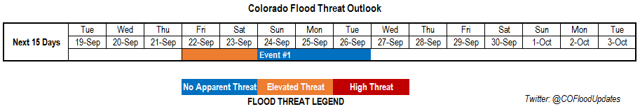
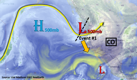
A much drier and cooler pattern arrived to Colorado toward the end of last week. As the cold front moved through the state, the streak of September heat was brought to an end. While temperatures will continue to rebound today and tomorrow, another cold front is forecasted to bring more climatologically normal temperatures Wednesday to eastern Colorado. There is one precipitation event that has been identified for this Outlook. In the water vapor imagery below, this event can be seen over the Pacific Northwest. The strong trough is forecasted to dig south, west of Colorado, and produce an unsettled weather pattern over the state beginning later this week. After this trough moves through, a quieter, more zonal pattern sets up for the remainder of next week. While models hint at another trough moving through the area at the end of this Outlook, confidence in details are not high enough to issue any threat at this time.
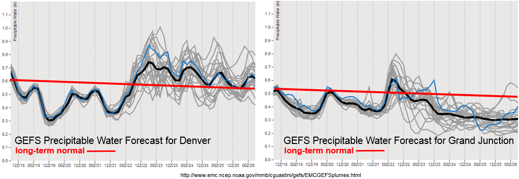
Below average Precipitable Water (PW) is forecasted for Denver and Grand Junction through Thursday night. As the trough digs south, winds are expected to increase in speed and become more southwesterly at the surface. The low relative humidity and warmer temperatures will create extreme fire danger from Tuesday night through Friday morning. Please avoid outdoor burning as increased wind speeds can quickly spread fires. Towards the end of the week, PW values increase over the state with the eastern portion of the state remaining above average through the weekend. The increase in moisture occurs the same time the west coast trough begins releasing shortwaves into the state. The upper level dynamics and increased moisture could bring heavy rain and severe weather to the eastern plains and snow to the high country on Saturday.
Below we describe the identified precipitation event in more detail.
Event #1: Friday (9/22) through Tuesday (9/26)
Elevated/No Apparent Threat as increased moisture pairs with upper level dynamics across Colorado
Moisture returns to southwest Colorado and the far eastern plains later this week. Increasing SW and SSW surface winds will draw in moisture as the trough digs south, west of Colorado. On Friday, the main upper level trough will begin to eject shortwaves over the state that will cause enhanced lift and unsettled weather for southwest Colorado. Saturday, a cold front associated with the west coast trough is expected to move through the state and drop temperatures enough over the mountains that a couple inches of snow may fall at elevations above 9,500 feet. Over the plains, the increased dynamics paired with higher moisture is expected to create favorable conditions for severe weather and prolonged rainfall. This main trough moves northeast through Colorado overnight on Sunday. An Elevated Flood threat has been issued for Friday and Saturday with no apparent threat on Sunday.
A second, weaker trough then develops southwest of Colorado on Monday and Tuesday. Southwest flow aloft will allow the mid-level energy to move across the state during this period. PW is expected to decrease quite a bit after Sunday, but there should be enough residual moisture for daily rounds of rainfall. At this time, there is no apparent flood threat on Monday and Tuesday.