Issue Date: Thursday, September 14, 2017
Issue Time: 12:15PM MDT
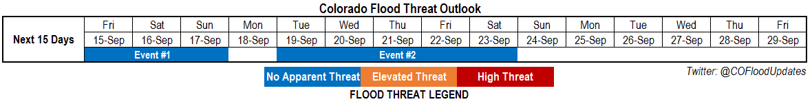
Valid Dates: 9/15-9/29
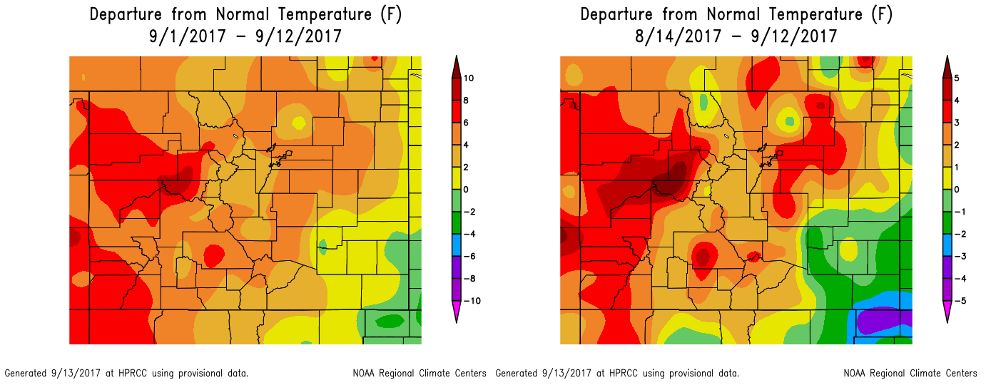
Although it is already mid-September, it has hardly felt like it statewide with month-to-date temperature anomalies up to +10F across the western parts of the state (see left panel below). In fact, even when we extend to the past 30 days, a similar pattern is seen with a slightly lower magnitude of anomalous warmth (right panel below). However, it seems that summer’s run may have ended as in this Outlook, we see evidence of an imminent pattern change to much cooler/colder conditions.
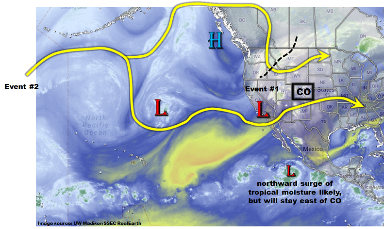
As shown in this afternoon’s water vapor image, below, the long standing ridge that dominated Colorado’s weather has finally been tempered down by an incoming large-scale disturbance. The upper-level pattern in western North America features a split flow in the jet stream: a northern “polar” branch, and a southern “subtropical” branch. There are disturbances in both branches, roughly in phase with one another that will combine to generate the first precipitation event. This will mainly be manifested as rain and snow showers across the western slope, with some embedded weak thunderstorms. Thereafter, this Event will carve out a strong upper-level trough across the Rocky Mountain states, which will provide much cooler conditions and upward motion for another precipitation event. The impulse that will support Event #2 is still far off in the western Pacific but will rapidly move eastward within the strong Pacific jet stream.
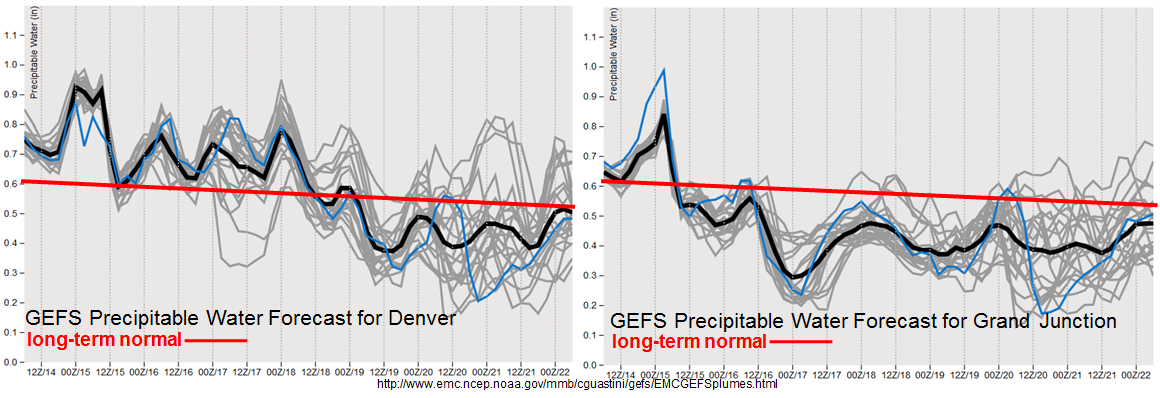
The forecasted Precipitable Water (PW) plumes from the GFS ensembles, below, show initially above normal moisture at both Grand Junction and Denver. However, PW values, along with boundary layer moisture, will remain below the necessary level to support heavy rainfall. Instead, both events will bring about the season’s first and second rounds of widespread precipitation coverage. With an influx of cold air from the northwest, both events will have snowfall. The Gore Range should receive a widespread coverage of at least 1 inch of precipitation (combined) with isolated locations receiving over 2 inches and perhaps more. The other big story is that much cooler conditions will be on the way statewide, but especially west of the Continental Divide where days with precipitation will be accompanied by temperatures up to 25F below normal. After Event #2, there will be a rebound in temperatures, though given that it is already mid-September, at this time it appears that summer-like heat may be on its way out for good.
Below we describe each of the two identified precipitation events in more detail.
Event #1: Friday (9/15) through Sunday (9/17)
No Apparent Flood Threat but multiple rounds of showers, weak storms and high elevation snowfall expected
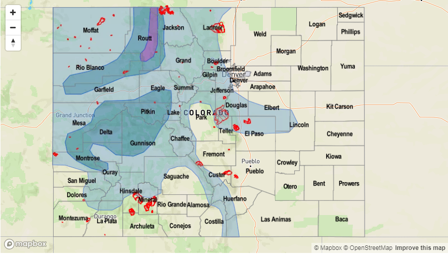
This disturbance will provide enhanced precipitation coverage over the Western Slope on Friday and Saturday, with coverage decreasing by Sunday. The most common precipitation type will be showers with embedded weak storms possible. Up to 1.5 inches of precipitation will be possible over a 24 hour period, with the greatest chances of meeting this intensity being in the higher elevations of the Gore Range, Roan Cliffs and Uncompahgre Plateau. Snow levels could drop as low as 9,500 feet overnight Saturday, especially near the Wyoming border. Flooding is not anticipated at this time, though a low-end flood threat could emerge for longer duration precipitation. Stay tuned to daily Flood Threat Bulletins for more specific, and up-to-date information.

Event #2: Tuesday (9/19) through Saturday (9/23)
No Apparent Flood Threat but precipitation coverage to increase again
Another disturbances is expected to arrive into the soon to be developed upper-level trough early next week. This disturbance will have similar features as Event #1, though with several important differences. First, instability is expected to be limited to non-existent, implying that precipitation will fall in the form of rain and snow bands void of thunderstorms. Second, this disturbance will have much colder air to work with, implying snow levels could drop to 6,500 feet towards the Wyoming border. There will be an initial band of enhanced mid-level moisture that will support up to 1.5 inches of rain and snow on Tuesday. Wednesday and Thursday will see drying conditions with more scattered precipitation. A secondary surge of moisture could provide another round of precipitation on Friday and Saturday. In all, a widespread precipitation event is expected for the Western Slope with over 2 inches of precipitation likely for the western facing slopes of the Gore Range. East of the Continental Divide, precipitation chances looks much less favorable and it is uncertain whether there will be over 0.5 inches anywhere. This represents a big difference from the last Outlook where it appeared tropical moisture may become involved. Currently, the tropical moisture plume is expected to stay far enough east to not impact Colorado. Flooding is not expected with this event.