Issue Date: Monday, September 11, 2017
Issue Time: 1:45PM MDT
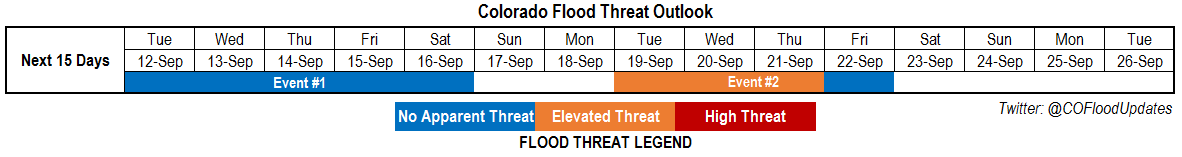
Valid Dates: 9/12-9/26
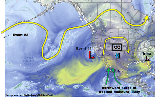
While chances of heavy rainfall in Colorado typically wane quickly during September, it is always prudent to appreciate that the state’s unique climate can support late season flooding such as the Front Range 2013 event. While we do not see anything particularly impressive for this 15-day Outlook, we do foresee an abnormally active period both in terms of rainfall coverage and intensity. As shown in the water vapor image, below, Colorado is currently under a weak upper-level ridge, sandwiched between the remnants of Hurricane Irma to the east and a cut-off (synonymous with “stubborn”) upper-level trough off the California coast. The latter feature will finally eject eastward over the next 48-96 hours, providing Colorado with nice rainfall coverage and generally limited rainfall intensity. We have labeled this feature as Event #1.
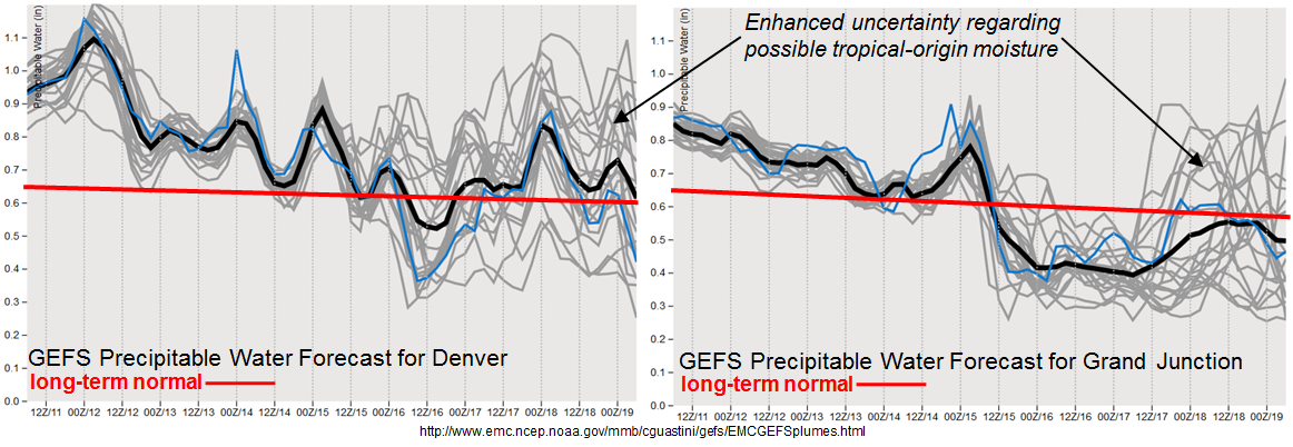
As shown in the GFS ensemble forecasted Precipitable Water (PW) plumes, below, PW will gradually decrease statewide as the disturbance supporting Event #1 approaches. Nonetheless, PW will remain above average and support up to 1.5 inches of rainfall, locally, in the climatogically favored San Juan Mountains and Southeast Mountains. Other locations will see less rainfall, but most locations should see at least a tenth of an inch over the course of this event.
The other interesting note about the forecasted PW plumes is the enhanced uncertainty by early next week.
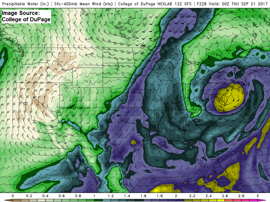
 This enhanced uncertainty is arising from a spread in guidance due to the possible interaction between a large-scale trough expected to enter the North American west coast and tropical moisture. There is reasonable confidence regarding the upper-level trough, which by itself will increase rainfall coverage and intensity. However, this afternoon’s GFS model guidance, below, shows a fetch of deep tropical moisture (from a recurving tropical cyclone) into the south/central United States. This could provide Colorado with a potential for longer duration heavy rainfall. At this time, it would be the southeast quadrant of the state that would be most vulnerable, but with plenty of uncertainty, stay tuned for this Thursday’s Outlook for more information.
Below we describe each of the two identified precipitation events in more detail.
Event #1: Tuesday (9/12) through Saturday (9/16)
No Apparent Flood Threat but increased rain coverage likely, especially over High Country
Precipitable Water values will remain above long-term average, combining with favorable upper-level dynamics to support daily rounds of moderate intensity thunderstorms and showers. The best coverage will be over the High Country (especially southern Colorado). Hourly rainfall rates up to 0.75 inches are expected over central and western Colorado with up to 1.25 inches for eastern areas. Over the course of the Event, up to 1.5 inches of rainfall could accumulate in isolated regions. At this time, we do not expect a flood threat, however, stay tuned to daily Flood Threat Bulletins as Tuesday and Wednesday could end up generating a Low flood threat if moisture levels are only slightly higher than currently anticipated.

Event #2: Tuesday (9/19) through Friday (9/22)
Elevated Flood Threat as dynamics and moisture could combine favorably
Another large-scale upper-level trough is likely to enter the North American west coast early next week. This feature, by itself, will cause an increase in rainfall coverage an intensity statewide but especially across the southern half of Colorado. Isolated heavy rainfall amounts exceeding thresholds for isolated flash flooding could occur across the San Juan, Southeast Mountains and Raton Ridge. If tropical moisture does end up becoming involved, a longer duration of heavy rainfall (preliminarily, in the 3-6 hour duration) can be expected over the southeast quadrant of the state. There is enough confidence to assign an Elevated flood threat for this event for isolated flash flooding. However, the placement of heavy rainfall is uncertain. Moreover, the possible impacts of longer-duration heavy rainfall are also currently very uncertain and not incorporated in the precipitation map below. Stay tuned to Thursday’s Outlook for a fresh look at this event.