Issue Date: Wednesday, August 16, 2017
Issue Time: 09:40AM MDT
—There is NO flood threat today
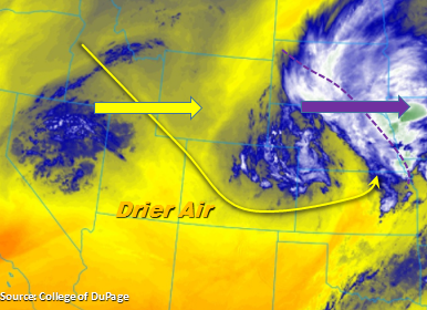
The upper level trough that helped support thunderstorm activity yesterday can be seen in the water vapor imagery below. The trough continues to move east this morning and is currently helping support cloud cover and light showers over the far eastern plains. The 500mb pattern today is a bit more zonal over Colorado before the ridge starts rebuilding itself the next couple of days. In the wake of the upper-level system, subsidence is forecasted over the majority of the state. This will limit widespread thunderstorm activity today. Precipitable Water (PW) at Denver and Grand Junction this morning are 0.79 and 0.70 inches, respectively. This forecasted to decrease statewide throughout the day as moisture retreats to the east. With lower surface pressures and westerly winds, the entire state will also see drying in the mid-levels. The most drying will occur over the western portion of the state, especially the SW corner.
Best chances for showers today are over the Front Range and adjacent plains over the Palmer Divide. Storms begin to initiate over the higher terrains later in the afternoon and slowly meander SE over the adjacent plains. With drying at the surface and mid-levels, gusty winds are more likely than heavy rainfall. Storms are expected to quickly end after sundown due to the lack of support of upper-level dynamics. There is no flood threat today.
Today’s Flood Threat Map
For more information on today’s flood threat, see the map below (hover over threat areas for more details). For Zone-Specific forecasts, scroll below the map.

Zone-Specific Forecasts:
Front Range, Urban Corridor, Palmer Ridge, Northeast Plains, Southeast Mountains, Raton Ridge, Southeast Plains:
Becoming mostly sunny with highs being a few degrees cooler today. Shower activity will be limited to the Front Range and Palmer ridge with 1-hr rain rates up to 0.6 (east) and .9 (west).
Primetime: 2PM to 10PM
Northwest Slope, Grand Valley, Southwest Slope, Northern Mountains, Central Mountains, San Juan Mountains, San Luis Valley:
Sunny throughout the day with some light clouds over the mountains this afternoon. Temperatures will be a bit cooler than the last couple of days. Isolated showers expected in the Northern Mountains with max 1-hr rainfall up to 0.5 inches. There is a no flood threat for today.
Primetime: 1PM to 9PM