Issue Date: Monday, August 14, 2017
Issue Time: 09:40AM MDT
— There is NO flood threat today
The 500mb ridge will build both north and east of Colorado today putting us under weaker and more westerly flow with a bit of a southerly component. This will cut off the influx of shortwaves that have helped enhanced thunderstorm activity over the last few days. There is some patchy fog this morning, which can be seen on the surface observations. This should quickly burn off and skies should be sunny most of the morning throughout the state. Dew points over the far eastern plains are up to 60F, and rapidly decrease to the west. Precipitable Water (PW) at Denver this morning was 0.71 inches and 0.88 inches at Grand Junction. The decrease in moisture continues, which in turn decreases the flood threat. This decrease in available moisture is not uncommon for August. There is a climatological decrease in PW that occurs at the beginning of this month.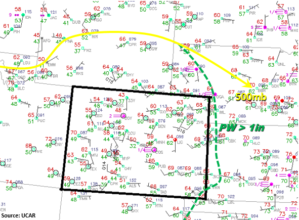
Today, scattered showers will form over the higher terrain just after noon. As these storms move off into the adjacent plains later in the afternoon, minimal atmospheric moisture will produce gusty winds and limit heavy precipitation. These more isolated storms will favor the higher terrains of the Palmer and Raton Ridge, but the many outflow boundaries may help trigger additional storms along the adjacent plains. These garden variety storms will move east, but are not expect to become severe today since the combination of instability and shear is negligible. Surface S/SE flow may return some moisture to far eastern plains, but the higher PW values will likely stay east of Colorado as will 1-hour rain rates exceeding 1.5 inches. Storms over the mountains will quickly end after sunset, while storms over the eastern plains may linger until midnight. There is no flood threat today.
Today’s Flood Threat Map
For more information on today’s flood threat, see the map below (hover over threat areas for more details). For Zone-Specific forecasts, scroll below the map.
Zone-Specific Forecasts:
Front Range, Urban Corridor, Palmer Ridge, Northeast Plains, Southeast Mountains, Raton Ridge, Southeast Plains:
Mostly sunny this morning becoming partly cloudy this afternoon as scatter storms form over the mountains. More isolated storms over the eastern plains this afternoon with the main threat being strong winds and possibly small hail. 1-hour rain rates up to 1.5 (east) and .75 (west).
Primetime: 12PM to 12AM
Northwest Slope, Grand Valley, Southwest Slope, Northern Mountains, Central Mountains, San Juan Mountains, San Luis Valley:
Sunny this morning becoming partly cloudy this afternoon with scattered showers forming over the higher terrain and Northwest Slope. Max 1-hr rainfall up to 0.6 inches. There is a no flood threat for today.
Primetime: 12PM to 8PM